
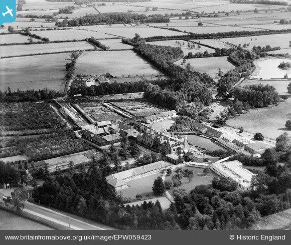
EPW059423 ENGLAND (1938). The Manfield Orthopaedic Hospital, Northampton, 1938
© Copyright OpenStreetMap contributors and licensed by the OpenStreetMap Foundation. 2025. Cartography is licensed as CC BY-SA.
Nearby Images (8)
EPW059423

EPW059417

EPW059424

EPW059419

EPW059421

EPW059422

EPW059418

EPW059420

Details
| Title | [EPW059423] The Manfield Orthopaedic Hospital, Northampton, 1938 |
| Reference | EPW059423 |
| Date | 13-September-1938 |
| Link | |
| Place name | NORTHAMPTON |
| Parish | |
| District | |
| Country | ENGLAND |
| Easting / Northing | 477857, 263652 |
| Longitude / Latitude | -0.85901354893531, 52.265116829303 |
| National Grid Reference | SP779637 |
Pins

foep.vic |
Thursday 10th of December 2015 09:01:05 PM | |
|
foep.vic |
Thursday 10th of December 2015 08:58:07 PM | |
|
foep.vic |
Thursday 10th of December 2015 08:57:32 PM | |
|
foep.vic |
Thursday 10th of December 2015 08:56:14 PM | |
|
foep.vic |
Thursday 10th of December 2015 08:54:05 PM | |
|
foep.vic |
Thursday 10th of December 2015 08:53:27 PM | |
|
foep.vic |
Thursday 10th of December 2015 08:51:43 PM | |
|
foep.vic |
Thursday 10th of December 2015 08:50:26 PM | |
|
foep.vic |
Thursday 10th of December 2015 08:49:16 PM | |
|
foep.vic |
Thursday 10th of December 2015 08:45:17 PM | |
|
foep.vic |
Thursday 10th of December 2015 08:42:23 PM |