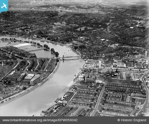
EPW059342 ENGLAND (1938). Hammersmith Bridge and environs, Fulham, from the south-east, 1938
© Copyright OpenStreetMap contributors and licensed by the OpenStreetMap Foundation. 2026. Cartography is licensed as CC BY-SA.
Nearby Images (16)
Details
| Title | [EPW059342] Hammersmith Bridge and environs, Fulham, from the south-east, 1938 |
| Reference | EPW059342 |
| Date | 12-September-1938 |
| Link | |
| Place name | FULHAM |
| Parish | |
| District | |
| Country | ENGLAND |
| Easting / Northing | 523412, 177585 |
| Longitude / Latitude | -0.222472540502, 51.483250860821 |
| National Grid Reference | TQ234776 |
Pins

Robin |
Friday 17th of January 2020 01:42:17 PM | |

Robin |
Friday 17th of January 2020 01:41:20 PM | |

The Laird |
Tuesday 1st of March 2016 03:59:55 PM | |

Class31 |
Tuesday 9th of September 2014 01:32:12 PM | |

Class31 |
Tuesday 9th of September 2014 01:25:17 PM | |

Class31 |
Tuesday 9th of September 2014 01:20:52 PM | |

Class31 |
Tuesday 9th of September 2014 01:17:00 PM | |

Class31 |
Tuesday 9th of September 2014 01:12:28 PM | |

Alan McFaden |
Friday 6th of September 2013 09:02:49 AM |


![[EPW059342] Hammersmith Bridge and environs, Fulham, from the south-east, 1938](http://britainfromabove.org.uk/sites/all/libraries/aerofilms-images/public/100x100/EPW/059/EPW059342.jpg)
![[EPW010782] A cityscape over Hammersmith and the River Thames, Hammersmith, 1924. This image has been produced from a damaged copy-negative.](http://britainfromabove.org.uk/sites/all/libraries/aerofilms-images/public/100x100/EPW/010/EPW010782.jpg)
![[EPW022804] Duckhams Oils and environs, Fulham, 1928](http://britainfromabove.org.uk/sites/all/libraries/aerofilms-images/public/100x100/EPW/022/EPW022804.jpg)
![[EPW024773] Manbre Saccharine Works, Bryce Westons Shirt Factory and environs, Fulham, 1928. This image has been produced from a print.](http://britainfromabove.org.uk/sites/all/libraries/aerofilms-images/public/100x100/EPW/024/EPW024773.jpg)
![[EPW024774] Manbre Saccharine Works, Bryce Westons Shirt Factory and environs, Fulham, 1928. This image has been produced from a damaged print.](http://britainfromabove.org.uk/sites/all/libraries/aerofilms-images/public/100x100/EPW/024/EPW024774.jpg)
![[EPW022803] Duckhams Oils and environs, Fulham, 1928](http://britainfromabove.org.uk/sites/all/libraries/aerofilms-images/public/100x100/EPW/022/EPW022803.jpg)
![[EPW024775] Manbre Saccharine Works and environs, Fulham, 1928](http://britainfromabove.org.uk/sites/all/libraries/aerofilms-images/public/100x100/EPW/024/EPW024775.jpg)
![[EPW022802] Duckhams Oils and environs, Fulham, 1928](http://britainfromabove.org.uk/sites/all/libraries/aerofilms-images/public/100x100/EPW/022/EPW022802.jpg)
![[EPW022799] Duckhams Oils and the Pimlico Wheel and Motor Works, Fulham, 1928](http://britainfromabove.org.uk/sites/all/libraries/aerofilms-images/public/100x100/EPW/022/EPW022799.jpg)
![[EPW022801] Duckhams Oils and environs, Fulham, 1928](http://britainfromabove.org.uk/sites/all/libraries/aerofilms-images/public/100x100/EPW/022/EPW022801.jpg)
![[EPW022800] Duckhams Oils and environs, Fulham, 1928](http://britainfromabove.org.uk/sites/all/libraries/aerofilms-images/public/100x100/EPW/022/EPW022800.jpg)
![[EPW022560] The Manbre Saccharine Works and environs, Fulham, from the south-west, 1928](http://britainfromabove.org.uk/sites/all/libraries/aerofilms-images/public/100x100/EPW/022/EPW022560.jpg)
![[EPW022805] Duckhams Oils and environs, Fulham, 1928](http://britainfromabove.org.uk/sites/all/libraries/aerofilms-images/public/100x100/EPW/022/EPW022805.jpg)
![[EPW022555] The Manbre Saccharine Works and environs, Fulham, from the south-west, 1928](http://britainfromabove.org.uk/sites/all/libraries/aerofilms-images/public/100x100/EPW/022/EPW022555.jpg)
![[EPW022554] Fulham Palace Road and environs, Fulham, from the west, 1928](http://britainfromabove.org.uk/sites/all/libraries/aerofilms-images/public/100x100/EPW/022/EPW022554.jpg)
![[EPW022557] Fulham Palace Road and environs, Fulham, from the west, 1928](http://britainfromabove.org.uk/sites/all/libraries/aerofilms-images/public/100x100/EPW/022/EPW022557.jpg)
