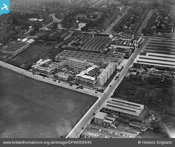
EPW058946 ENGLAND (1938). Coleman Court, Kimber Road, Burr Road and environs, Southfields, 1938
© Copyright OpenStreetMap contributors and licensed by the OpenStreetMap Foundation. 2026. Cartography is licensed as CC BY-SA.
Nearby Images (18)
Details
| Title | [EPW058946] Coleman Court, Kimber Road, Burr Road and environs, Southfields, 1938 |
| Reference | EPW058946 |
| Date | 30-August-1938 |
| Link | |
| Place name | SOUTHFIELDS |
| Parish | |
| District | |
| Country | ENGLAND |
| Easting / Northing | 525440, 173668 |
| Longitude / Latitude | -0.19466858616561, 51.44759827787 |
| National Grid Reference | TQ254737 |
Pins
Be the first to add a comment to this image!


![[EPW058946] Coleman Court, Kimber Road, Burr Road and environs, Southfields, 1938](http://britainfromabove.org.uk/sites/all/libraries/aerofilms-images/public/100x100/EPW/058/EPW058946.jpg)
![[EPW058949] Coleman Court, Kimber Road, Burr Road and environs, Southfields, 1938](http://britainfromabove.org.uk/sites/all/libraries/aerofilms-images/public/100x100/EPW/058/EPW058949.jpg)
![[EPW060341] Coleman Court, Kimber Road, Burr Road and environs, Southfields, 1939](http://britainfromabove.org.uk/sites/all/libraries/aerofilms-images/public/100x100/EPW/060/EPW060341.jpg)
![[EPW060340] Coleman Court, Kimber Road, Burr Road and environs, Southfields, 1939](http://britainfromabove.org.uk/sites/all/libraries/aerofilms-images/public/100x100/EPW/060/EPW060340.jpg)
![[EPW058947] Coleman Court on Kimber Road, Southfields, 1938](http://britainfromabove.org.uk/sites/all/libraries/aerofilms-images/public/100x100/EPW/058/EPW058947.jpg)
![[EPW058948] Coleman Court, Kimber Road, Burr Road and environs, Southfields, 1938](http://britainfromabove.org.uk/sites/all/libraries/aerofilms-images/public/100x100/EPW/058/EPW058948.jpg)
![[EPW060338] Coleman Court, Kimber Road, Burr Road and environs, Southfields, 1939](http://britainfromabove.org.uk/sites/all/libraries/aerofilms-images/public/100x100/EPW/060/EPW060338.jpg)
![[EPW060337] Coleman Court, Kimber Road, Burr Road and environs, Southfields, 1939](http://britainfromabove.org.uk/sites/all/libraries/aerofilms-images/public/100x100/EPW/060/EPW060337.jpg)
![[EPW060339] Coleman Court, Kimber Road, Burr Road and environs, Southfields, 1939](http://britainfromabove.org.uk/sites/all/libraries/aerofilms-images/public/100x100/EPW/060/EPW060339.jpg)
![[EPW058595] Coleman Court, Kimber Road, Burr Road and environs, Southfields, 1938](http://britainfromabove.org.uk/sites/all/libraries/aerofilms-images/public/100x100/EPW/058/EPW058595.jpg)
![[EPW060336] Coleman Court, Kimber Road, Burr Road and environs, Southfields, 1939](http://britainfromabove.org.uk/sites/all/libraries/aerofilms-images/public/100x100/EPW/060/EPW060336.jpg)
![[EPW058597] Coleman Court, Kimber Road, Burr Road and environs, Southfields, 1938](http://britainfromabove.org.uk/sites/all/libraries/aerofilms-images/public/100x100/EPW/058/EPW058597.jpg)
![[EPW058598] Coleman Court, Kimber Road, Burr Road and environs, Southfields, 1938](http://britainfromabove.org.uk/sites/all/libraries/aerofilms-images/public/100x100/EPW/058/EPW058598.jpg)
![[EPW058596] Coleman Court, Kimber Road, Burr Road and environs, Southfields, 1938](http://britainfromabove.org.uk/sites/all/libraries/aerofilms-images/public/100x100/EPW/058/EPW058596.jpg)
![[EAW000093] The A. H. Hunt Ltd Capacitor Works alongside the River Wandle, Earlsfield, 1946](http://britainfromabove.org.uk/sites/all/libraries/aerofilms-images/public/100x100/EAW/000/EAW000093.jpg)
![[EAW000092] The A. H. Hunt Ltd Capacitor Works alongside the River Wandle, Earlsfield, 1946](http://britainfromabove.org.uk/sites/all/libraries/aerofilms-images/public/100x100/EAW/000/EAW000092.jpg)
![[EAW000091] The A. H. Hunt Ltd Capacitor Works alongside the River Wandle, Earlsfield, 1946. This image has been produced from a damaged negative.](http://britainfromabove.org.uk/sites/all/libraries/aerofilms-images/public/100x100/EAW/000/EAW000091.jpg)
![[EPW031954] The Columbia Gramophone Works and environs, Wandsworth, 1930. This image was marked by Aerofilms Ltd for photo editing.](http://britainfromabove.org.uk/sites/all/libraries/aerofilms-images/public/100x100/EPW/031/EPW031954.jpg)