
EPW057606 ENGLAND (1938). The Hendon Greyhound Racing Stadium and Kemps Biscuit Works off the North Circular Road and the surrounding area, Dollis Hill, 1938. This image has been produced from a copy-negative.

© Copyright OpenStreetMap contributors and licensed by the OpenStreetMap Foundation. 2026. Cartography is licensed as CC BY-SA.
Nearby Images (45)
EPW057606

EPW032145

EPW032146

EPW032144

EPW050427

EPW050426

EAW048506

EPW020221

EPW032151

EPW040799

EAW004146

EAW048510

EPW032171

EAW004149

EAW048511

EPW038699

EPW020220

EPW032153

EAW004144

EPW032152

EPW032172

EPW040803

EPW040806

EAW048509

EPW046460

EAW004145

EAW048505

EAW004147

EPW046461

EAW004148

EPW040801

EPW040804

EPW040800

EAW048512

EPW040802

EPW032177

EPW013748

EPW053783

EPW038802

EPW040798

EPW038799

EPW055759

EAW048508

EAW048507

EPW055760

Details
| Title | [EPW057606] The Hendon Greyhound Racing Stadium and Kemps Biscuit Works off the North Circular Road and the surrounding area, Dollis Hill, 1938. This image has been produced from a copy-negative. |
| Reference | EPW057606 |
| Date | July-1938 |
| Link | |
| Place name | DOLLIS HILL |
| Parish | |
| District | |
| Country | ENGLAND |
| Easting / Northing | 522464, 187092 |
| Longitude / Latitude | -0.2328139462625, 51.568907722528 |
| National Grid Reference | TQ225871 |
Pins

Mark Amies |
Thursday 3rd of February 2022 03:20:53 PM | |
|
Mark Amies |
Thursday 3rd of February 2022 03:18:47 PM | |
|
The Laird |
Wednesday 19th of September 2018 01:51:03 PM | |
|
The Laird |
Wednesday 19th of September 2018 01:43:16 PM | |
 |
Leslie B |
Tuesday 15th of March 2016 08:49:40 PM |
|
Kentishman |
Tuesday 9th of February 2016 11:05:41 PM | |
|
Kentishman |
Tuesday 9th of February 2016 10:36:34 PM | |
|
ken |
Sunday 16th of August 2015 03:02:03 PM | |
|
ken |
Sunday 16th of August 2015 03:01:22 PM | |
|
ken |
Sunday 16th of August 2015 02:59:56 PM | |
|
clive |
Thursday 4th of December 2014 06:53:25 PM |
User Comment Contributions
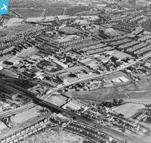
This image shows the GPO's Research Centre, Dollis Hill. This site was vital for the work undertaken to design and build Colossus, the World's first electronic, programmable computer in 1943. This became an essential part of the work at Bletchley Park in deciphering codes that the Germans considered unbreakable. Dollis Hill was also the site of Paddock, the reserve Cabinet War Room completed in 1940. |
Kentishman |
Tuesday 9th of February 2016 10:52:43 PM |