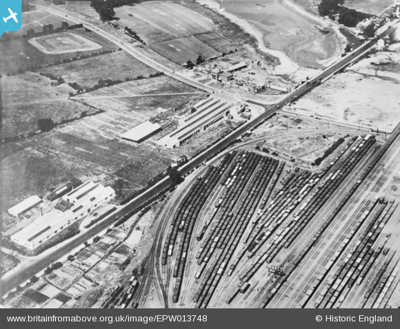
EPW013748 ENGLAND (1925). Staples Corner, Dollis Hill, 1925. This image has been produced from a copy-negative.
© Copyright OpenStreetMap contributors and licensed by the OpenStreetMap Foundation. 2026. Cartography is licensed as CC BY-SA.
Nearby Images (21)
Details
| Title | [EPW013748] Staples Corner, Dollis Hill, 1925. This image has been produced from a copy-negative. |
| Reference | EPW013748 |
| Date | July-1925 |
| Link | |
| Place name | DOLLIS HILL |
| Parish | |
| District | |
| Country | ENGLAND |
| Easting / Northing | 522677, 187167 |
| Longitude / Latitude | -0.22971569112741, 51.569535519534 |
| National Grid Reference | TQ227872 |
Pins

John W |
Thursday 3rd of October 2024 10:32:01 PM | |

John W |
Thursday 3rd of October 2024 10:29:15 PM | |

John W |
Thursday 3rd of October 2024 10:28:36 PM | |

John W |
Thursday 3rd of October 2024 10:27:37 PM | |

John W |
Thursday 3rd of October 2024 10:26:16 PM | |

John W |
Thursday 3rd of October 2024 10:24:55 PM | |

John W |
Thursday 3rd of October 2024 10:21:36 PM | |

Mark Amies |
Wednesday 9th of January 2019 03:48:02 PM | |

Mark Amies |
Wednesday 9th of January 2019 02:25:08 PM | |

The Laird |
Wednesday 19th of September 2018 02:35:45 PM |


![[EPW013748] Staples Corner, Dollis Hill, 1925. This image has been produced from a copy-negative.](http://britainfromabove.org.uk/sites/all/libraries/aerofilms-images/public/100x100/EPW/013/EPW013748.jpg)
![[EPW038799] North Circular Road at Brent Bridge and environs, Golders Green, from the south-west, 1932](http://britainfromabove.org.uk/sites/all/libraries/aerofilms-images/public/100x100/EPW/038/EPW038799.jpg)
![[EPW032172] The Staples Mattress Factory and Staples Corner, Dollis Hill, 1930](http://britainfromabove.org.uk/sites/all/libraries/aerofilms-images/public/100x100/EPW/032/EPW032172.jpg)
![[EPW038802] North Circular Road at Brent Bridge and environs, Golders Green, from the south-west, 1932](http://britainfromabove.org.uk/sites/all/libraries/aerofilms-images/public/100x100/EPW/038/EPW038802.jpg)
![[EPW032171] The Staples Mattress Factory and Staples Corner, Dollis Hill, 1930](http://britainfromabove.org.uk/sites/all/libraries/aerofilms-images/public/100x100/EPW/032/EPW032171.jpg)
![[EPW053783] Traffic congestion at Staples Corner, Dollis Hill, 1937](http://britainfromabove.org.uk/sites/all/libraries/aerofilms-images/public/100x100/EPW/053/EPW053783.jpg)
![[EPW040803] The Bovis Ltd Works, Kemps Biscuit Works and environs, Dollis Hill, 1933](http://britainfromabove.org.uk/sites/all/libraries/aerofilms-images/public/100x100/EPW/040/EPW040803.jpg)
![[EPW040802] The Bovis Ltd Works, Kemps Biscuit Works and environs, Dollis Hill, 1933](http://britainfromabove.org.uk/sites/all/libraries/aerofilms-images/public/100x100/EPW/040/EPW040802.jpg)
![[EPW032145] Scribbans-Kemp Biscuit Factory and environs, Dollis Hill, 1930](http://britainfromabove.org.uk/sites/all/libraries/aerofilms-images/public/100x100/EPW/032/EPW032145.jpg)
![[EPW040800] The Bovis Ltd Works, Kemps Biscuit Works and Brent Reservoir, Dollis Hill, 1933](http://britainfromabove.org.uk/sites/all/libraries/aerofilms-images/public/100x100/EPW/040/EPW040800.jpg)
![[EPW053785] Traffic congestion at Staples Corner and Brent Bridge, Hendon, 1937](http://britainfromabove.org.uk/sites/all/libraries/aerofilms-images/public/100x100/EPW/053/EPW053785.jpg)
![[EPW040799] The Bovis Ltd Works, Kemps Biscuit Works and environs, Dollis Hill, 1933. This image has been produced from a damaged negative.](http://britainfromabove.org.uk/sites/all/libraries/aerofilms-images/public/100x100/EPW/040/EPW040799.jpg)
![[EPW057606] The Hendon Greyhound Racing Stadium and Kemps Biscuit Works off the North Circular Road and the surrounding area, Dollis Hill, 1938. This image has been produced from a copy-negative.](http://britainfromabove.org.uk/sites/all/libraries/aerofilms-images/public/100x100/EPW/057/EPW057606.jpg)
![[EPW040804] The Bovis Ltd Works, Kemps Biscuit Works and environs, Dollis Hill, 1933](http://britainfromabove.org.uk/sites/all/libraries/aerofilms-images/public/100x100/EPW/040/EPW040804.jpg)
![[EAW048505] The Rockwell Machine Tool Co Ltd Works on Hendon Broadway and nearby factories along the North Circular Road, Dollis Hill, 1953](http://britainfromabove.org.uk/sites/all/libraries/aerofilms-images/public/100x100/EAW/048/EAW048505.jpg)
![[EPW032146] Scribbans-Kemp Biscuit Factory and environs, Dollis Hill, 1930](http://britainfromabove.org.uk/sites/all/libraries/aerofilms-images/public/100x100/EPW/032/EPW032146.jpg)
![[EPW040801] The Bovis Ltd Works, Kemps Biscuit Works and environs, Dollis Hill, 1933](http://britainfromabove.org.uk/sites/all/libraries/aerofilms-images/public/100x100/EPW/040/EPW040801.jpg)
![[EAW048506] The Rockwell Machine Tool Co Ltd Works on Hendon Broadway and nearby factories along the North Circular Road, Dollis Hill, 1953. This image was marked by Aerofilms Ltd for photo editing.](http://britainfromabove.org.uk/sites/all/libraries/aerofilms-images/public/100x100/EAW/048/EAW048506.jpg)
![[EAW048509] The Rockwell Machine Tool Co Ltd Works on Hendon Broadway and nearby factories along the North Circular Road, Dollis Hill, 1953. This image was marked by Aerofilms Ltd for photo editing.](http://britainfromabove.org.uk/sites/all/libraries/aerofilms-images/public/100x100/EAW/048/EAW048509.jpg)
![[EPW040806] The Bovis Ltd Works, Kemps Biscuit Works and environs, Dollis Hill, 1933](http://britainfromabove.org.uk/sites/all/libraries/aerofilms-images/public/100x100/EPW/040/EPW040806.jpg)
![[EAW048508] The Rockwell Machine Tool Co Ltd Works on Hendon Broadway and part of Brent Reservoir, Dollis Hill, 1953. This image was marked by Aerofilms Ltd for photo editing.](http://britainfromabove.org.uk/sites/all/libraries/aerofilms-images/public/100x100/EAW/048/EAW048508.jpg)
