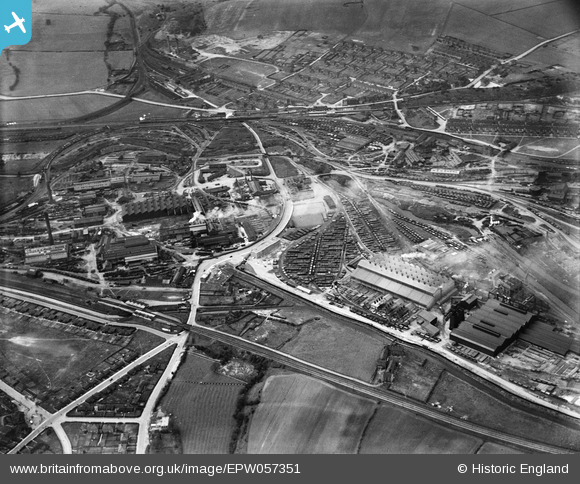
EPW057351 ENGLAND (1938). The Staveley Coal and Iron Company Ltd Works, Staveley, 1938
© Copyright OpenStreetMap contributors and licensed by the OpenStreetMap Foundation. 2026. Cartography is licensed as CC BY-SA.
Nearby Images (15)
Details
| Title | [EPW057351] The Staveley Coal and Iron Company Ltd Works, Staveley, 1938 |
| Reference | EPW057351 |
| Date | 3-June-1938 |
| Link | |
| Place name | STAVELEY |
| Parish | STAVELEY |
| District | |
| Country | ENGLAND |
| Easting / Northing | 441660, 374863 |
| Longitude / Latitude | -1.3752808270566, 53.26884306912 |
| National Grid Reference | SK417749 |
Pins
Be the first to add a comment to this image!


![[EPW057351] The Staveley Coal and Iron Company Ltd Works, Staveley, 1938](http://britainfromabove.org.uk/sites/all/libraries/aerofilms-images/public/100x100/EPW/057/EPW057351.jpg)
![[EPW057337] The Staveley Coal and Iron Company Ltd Works, Staveley, 1938](http://britainfromabove.org.uk/sites/all/libraries/aerofilms-images/public/100x100/EPW/057/EPW057337.jpg)
![[EAW006281] The Staveley Iron Works, Staveley, 1947](http://britainfromabove.org.uk/sites/all/libraries/aerofilms-images/public/100x100/EAW/006/EAW006281.jpg)
![[EAW006282] The Staveley Iron Works, Staveley, 1947](http://britainfromabove.org.uk/sites/all/libraries/aerofilms-images/public/100x100/EAW/006/EAW006282.jpg)
![[EAW006283] The Staveley Iron Works, Staveley, 1947](http://britainfromabove.org.uk/sites/all/libraries/aerofilms-images/public/100x100/EAW/006/EAW006283.jpg)
![[EAW006280] The Staveley Iron Works, Staveley, 1947](http://britainfromabove.org.uk/sites/all/libraries/aerofilms-images/public/100x100/EAW/006/EAW006280.jpg)
![[EAW043845] The Staveley Iron Works and Barrow Hill, Staveley, 1952](http://britainfromabove.org.uk/sites/all/libraries/aerofilms-images/public/100x100/EAW/043/EAW043845.jpg)
![[EAW044345] The Staveley Coal and Iron Company Ltd Works, Staveley, 1952](http://britainfromabove.org.uk/sites/all/libraries/aerofilms-images/public/100x100/EAW/044/EAW044345.jpg)
![[EPW057341] The Staveley Coal and Iron Company Ltd Works, Staveley, 1938](http://britainfromabove.org.uk/sites/all/libraries/aerofilms-images/public/100x100/EPW/057/EPW057341.jpg)
![[EAW003058] The Staveley Iron Works and environs, Staveley, from the south-east, 1946](http://britainfromabove.org.uk/sites/all/libraries/aerofilms-images/public/100x100/EAW/003/EAW003058.jpg)
![[EPW041672] The Staveley Iron Works, Staveley, 1933. This image has been affected by flare.](http://britainfromabove.org.uk/sites/all/libraries/aerofilms-images/public/100x100/EPW/041/EPW041672.jpg)
![[EPW041667] The Staveley Iron Works, Staveley, 1933](http://britainfromabove.org.uk/sites/all/libraries/aerofilms-images/public/100x100/EPW/041/EPW041667.jpg)
![[EPW041670] The Staveley Iron Works and environs, Staveley, 1933](http://britainfromabove.org.uk/sites/all/libraries/aerofilms-images/public/100x100/EPW/041/EPW041670.jpg)
![[EAW003060] The Staveley Iron Works and environs, Staveley, 1946](http://britainfromabove.org.uk/sites/all/libraries/aerofilms-images/public/100x100/EAW/003/EAW003060.jpg)
![[EPW041668] The Staveley Iron Works and environs, Staveley, 1933](http://britainfromabove.org.uk/sites/all/libraries/aerofilms-images/public/100x100/EPW/041/EPW041668.jpg)