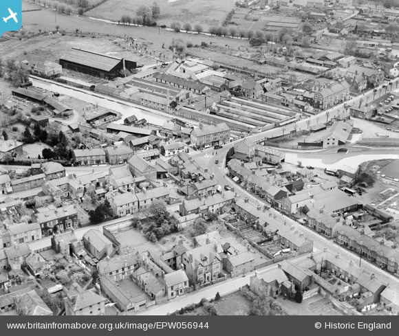
EPW056944 ENGLAND (1938). Morgan and Co Carriage Works, Wing Road and environs, Linslade, 1938
© Copyright OpenStreetMap contributors and licensed by the OpenStreetMap Foundation. 2026. Cartography is licensed as CC BY-SA.
Nearby Images (16)
Details
| Title | [EPW056944] Morgan and Co Carriage Works, Wing Road and environs, Linslade, 1938 |
| Reference | EPW056944 |
| Date | 26-April-1938 |
| Link | |
| Place name | LINSLADE |
| Parish | LEIGHTON-LINSLADE |
| District | |
| Country | ENGLAND |
| Easting / Northing | 491502, 225048 |
| Longitude / Latitude | -0.66946604774658, 51.915998101018 |
| National Grid Reference | SP915250 |
Pins

Vonderene |
Friday 23rd of August 2013 05:38:38 PM | |

Vonderene |
Friday 23rd of August 2013 05:37:50 PM | |

Vonderene |
Friday 23rd of August 2013 05:36:07 PM | |

Vonderene |
Friday 23rd of August 2013 05:33:54 PM | |

Vonderene |
Friday 23rd of August 2013 05:32:53 PM | |

Vonderene |
Friday 23rd of August 2013 05:30:42 PM | |

Vonderene |
Friday 23rd of August 2013 05:30:08 PM |


![[EPW056944] Morgan and Co Carriage Works, Wing Road and environs, Linslade, 1938](http://britainfromabove.org.uk/sites/all/libraries/aerofilms-images/public/100x100/EPW/056/EPW056944.jpg)
![[EPW056943] Whichello's Wharf and environs, Linslade, 1938](http://britainfromabove.org.uk/sites/all/libraries/aerofilms-images/public/100x100/EPW/056/EPW056943.jpg)
![[EAW029609] Grant's Wharf, the Grand Union Canal and flooding around the River Ouzel, Linslade, from the north, 1950](http://britainfromabove.org.uk/sites/all/libraries/aerofilms-images/public/100x100/EAW/029/EAW029609.jpg)
![[EAW016586] The Foundry Equipment Co Ltd Linslade Works and Linslade, Leighton Buzzard, 1948. This image was marked by Aerofilms Ltd for photo editing.](http://britainfromabove.org.uk/sites/all/libraries/aerofilms-images/public/100x100/EAW/016/EAW016586.jpg)
![[EAW029603] Old Road, Stoke Road and environs, Linslade, from the south-west, 1950](http://britainfromabove.org.uk/sites/all/libraries/aerofilms-images/public/100x100/EAW/029/EAW029603.jpg)
![[EAW016585] The Foundry Equipment Co Ltd Linslade Works and Linslade, Leighton Buzzard, 1948](http://britainfromabove.org.uk/sites/all/libraries/aerofilms-images/public/100x100/EAW/016/EAW016585.jpg)
![[EAW029606] Old Road, Linslade, 1950](http://britainfromabove.org.uk/sites/all/libraries/aerofilms-images/public/100x100/EAW/029/EAW029606.jpg)
![[EAW029602] New Road and environs, Linslade, 1950](http://britainfromabove.org.uk/sites/all/libraries/aerofilms-images/public/100x100/EAW/029/EAW029602.jpg)
![[EAW016584] The Foundry Equipment Co Ltd Linslade Works, Leighton Buzzard, from the south-east, 1948. This image has been produced from a damaged negative.](http://britainfromabove.org.uk/sites/all/libraries/aerofilms-images/public/100x100/EAW/016/EAW016584.jpg)
![[EAW029605] Old Road, Linslade, 1950](http://britainfromabove.org.uk/sites/all/libraries/aerofilms-images/public/100x100/EAW/029/EAW029605.jpg)
![[EAW016587] The Foundry Equipment Co Ltd Linslade Works, Leighton Buzzard, 1948. This image was marked by Aerofilms Ltd for photo editing.](http://britainfromabove.org.uk/sites/all/libraries/aerofilms-images/public/100x100/EAW/016/EAW016587.jpg)
![[EAW029604] New Road and Church Road, Linslade, 1950](http://britainfromabove.org.uk/sites/all/libraries/aerofilms-images/public/100x100/EAW/029/EAW029604.jpg)
![[EAW029607] Old Road and New Road, Linslade, 1950](http://britainfromabove.org.uk/sites/all/libraries/aerofilms-images/public/100x100/EAW/029/EAW029607.jpg)
![[EAW016588] The Foundry Equipment Co Ltd Linslade Works, All Saints' Church and environs, Leighton Buzzard, 1948. This image was marked by Aerofilms Ltd for photo editing.](http://britainfromabove.org.uk/sites/all/libraries/aerofilms-images/public/100x100/EAW/016/EAW016588.jpg)
![[EAW016582] The Foundry Equipment Co Ltd Linslade Works, Leighton Buzzard, 1948](http://britainfromabove.org.uk/sites/all/libraries/aerofilms-images/public/100x100/EAW/016/EAW016582.jpg)
![[EAW016583] The Foundry Equipment Co Ltd Linslade Works, Leighton Buzzard, 1948. This image has been produced from a damaged negative.](http://britainfromabove.org.uk/sites/all/libraries/aerofilms-images/public/100x100/EAW/016/EAW016583.jpg)