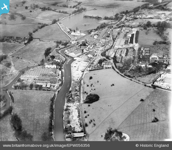
EPW056356 ENGLAND (1938). Harefield Mills on the Grand Union Canal and the site of the disused Harefield Mills, Harefield, 1938
© Copyright OpenStreetMap contributors and licensed by the OpenStreetMap Foundation. 2026. Cartography is licensed as CC BY-SA.
Nearby Images (24)
Details
| Title | [EPW056356] Harefield Mills on the Grand Union Canal and the site of the disused Harefield Mills, Harefield, 1938 |
| Reference | EPW056356 |
| Date | 5-February-1938 |
| Link | |
| Place name | HAREFIELD |
| Parish | |
| District | |
| Country | ENGLAND |
| Easting / Northing | 504132, 190926 |
| Longitude / Latitude | -0.49610489438241, 51.607057145794 |
| National Grid Reference | TQ041909 |
Pins
Be the first to add a comment to this image!


![[EPW056356] Harefield Mills on the Grand Union Canal and the site of the disused Harefield Mills, Harefield, 1938](http://britainfromabove.org.uk/sites/all/libraries/aerofilms-images/public/100x100/EPW/056/EPW056356.jpg)
![[EPW056357] Harefield Mills on the Grand Union Canal and the site of the disused Harefield Mills, Harefield, 1938](http://britainfromabove.org.uk/sites/all/libraries/aerofilms-images/public/100x100/EPW/056/EPW056357.jpg)
![[EPW006203] Harefield Mills on the Grand Union Canal, Harefield, from the south, 1921](http://britainfromabove.org.uk/sites/all/libraries/aerofilms-images/public/100x100/EPW/006/EPW006203.jpg)
![[EPW006653] Bells United Asbestos Works, Harefield, 1921](http://britainfromabove.org.uk/sites/all/libraries/aerofilms-images/public/100x100/EPW/006/EPW006653.jpg)
![[EPW006655] Bells United Asbestos Works, Maple Cross, 1921](http://britainfromabove.org.uk/sites/all/libraries/aerofilms-images/public/100x100/EPW/006/EPW006655.jpg)
![[EPW006656] View of Bells United Asbestos Works, Maple Cross, from the west, 1921](http://britainfromabove.org.uk/sites/all/libraries/aerofilms-images/public/100x100/EPW/006/EPW006656.jpg)
![[EPW006664] Bells United Asbestos Works, Harefield, 1921](http://britainfromabove.org.uk/sites/all/libraries/aerofilms-images/public/100x100/EPW/006/EPW006664.jpg)
![[EPW006660] Bells United Asbestos Works, Harefield, 1921](http://britainfromabove.org.uk/sites/all/libraries/aerofilms-images/public/100x100/EPW/006/EPW006660.jpg)
![[EPW006665] View of Bells United Asbestos Works, Maple Cross, from the south, 1921](http://britainfromabove.org.uk/sites/all/libraries/aerofilms-images/public/100x100/EPW/006/EPW006665.jpg)
![[EPW006662] View of Bells United Asbestos Works, Maple Cross, from the west, 1921](http://britainfromabove.org.uk/sites/all/libraries/aerofilms-images/public/100x100/EPW/006/EPW006662.jpg)
![[EPW041109] Harefield Mills (disused) on the Grand Union Canal, Harefield, 1933](http://britainfromabove.org.uk/sites/all/libraries/aerofilms-images/public/100x100/EPW/041/EPW041109.jpg)
![[EPW006659] Bells United Asbestos Works, Harefield, 1921](http://britainfromabove.org.uk/sites/all/libraries/aerofilms-images/public/100x100/EPW/006/EPW006659.jpg)
![[EPW056355] Harefield Mills on the Grand Union Canal, Harefield, 1938](http://britainfromabove.org.uk/sites/all/libraries/aerofilms-images/public/100x100/EPW/056/EPW056355.jpg)
![[EPW006657] Bells United Asbestos Works, Harefield, 1921](http://britainfromabove.org.uk/sites/all/libraries/aerofilms-images/public/100x100/EPW/006/EPW006657.jpg)
![[EPW006668] Bells United Asbestos Works, Harefield, 1921](http://britainfromabove.org.uk/sites/all/libraries/aerofilms-images/public/100x100/EPW/006/EPW006668.jpg)
![[EPW041108] Harefield Mills (disused) on the Grand Union Canal, Harefield, 1933](http://britainfromabove.org.uk/sites/all/libraries/aerofilms-images/public/100x100/EPW/041/EPW041108.jpg)
![[EPW056349] Harefield Mills on the Grand Union Canal, Harefield, 1938](http://britainfromabove.org.uk/sites/all/libraries/aerofilms-images/public/100x100/EPW/056/EPW056349.jpg)
![[EPW057662] The Bell Rubber Works, Harefield, 1938](http://britainfromabove.org.uk/sites/all/libraries/aerofilms-images/public/100x100/EPW/057/EPW057662.jpg)
![[EPW057661] The Bell Rubber Works, Harefield, 1938. This image has been produced from a damaged negative.](http://britainfromabove.org.uk/sites/all/libraries/aerofilms-images/public/100x100/EPW/057/EPW057661.jpg)
![[EPW006654] View of Bells United Asbestos Works, Maple Cross, from the west, 1921](http://britainfromabove.org.uk/sites/all/libraries/aerofilms-images/public/100x100/EPW/006/EPW006654.jpg)
![[EPW006658] Bells United Asbestos Works, Harefield, 1921](http://britainfromabove.org.uk/sites/all/libraries/aerofilms-images/public/100x100/EPW/006/EPW006658.jpg)
![[EPW006663] Bells United Asbestos Works, Harefield, 1921](http://britainfromabove.org.uk/sites/all/libraries/aerofilms-images/public/100x100/EPW/006/EPW006663.jpg)
![[EPW006667] Bells United Asbestos Works, Harefield, 1921](http://britainfromabove.org.uk/sites/all/libraries/aerofilms-images/public/100x100/EPW/006/EPW006667.jpg)
![[EPW006666] View of Bells United Asbestos Works and the Distemper Works, Maple Cross, from the south-west, 1921](http://britainfromabove.org.uk/sites/all/libraries/aerofilms-images/public/100x100/EPW/006/EPW006666.jpg)