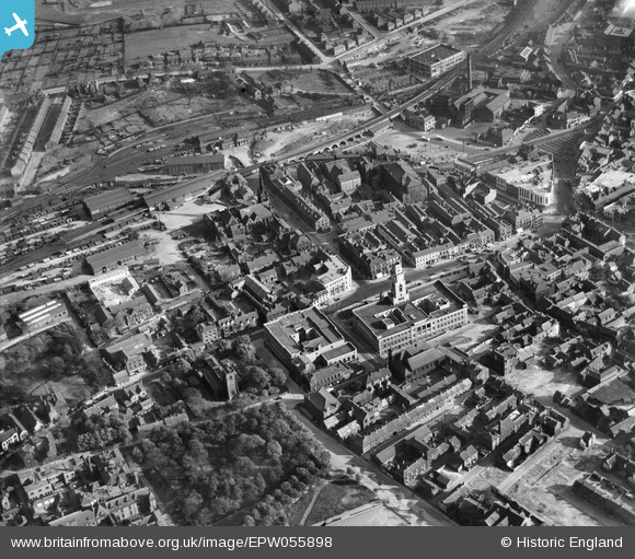
EPW055898 ENGLAND (1937). The Town Hall and environs, Barnsley, 1937
© Copyright OpenStreetMap contributors and licensed by the OpenStreetMap Foundation. 2026. Cartography is licensed as CC BY-SA.
Nearby Images (16)
Details
| Title | [EPW055898] The Town Hall and environs, Barnsley, 1937 |
| Reference | EPW055898 |
| Date | 24-October-1937 |
| Link | |
| Place name | BARNSLEY |
| Parish | |
| District | |
| Country | ENGLAND |
| Easting / Northing | 434445, 406549 |
| Longitude / Latitude | -1.480006706651, 53.554193415908 |
| National Grid Reference | SE344065 |
Pins

Big_Bob |
Tuesday 28th of February 2023 10:18:08 PM | |

ncbnik |
Sunday 8th of January 2023 07:43:53 PM | |

ncbnik |
Sunday 8th of January 2023 07:38:47 PM | |

ncbnik |
Sunday 8th of January 2023 07:35:50 PM | |

ncbnik |
Sunday 8th of January 2023 07:33:54 PM | |

ncbnik |
Sunday 8th of January 2023 07:29:47 PM | |

ncbnik |
Sunday 8th of January 2023 07:28:18 PM |


![[EPW055898] The Town Hall and environs, Barnsley, 1937](http://britainfromabove.org.uk/sites/all/libraries/aerofilms-images/public/100x100/EPW/055/EPW055898.jpg)
![[EPW061490] The town centre, Barnsley, 1939](http://britainfromabove.org.uk/sites/all/libraries/aerofilms-images/public/100x100/EPW/061/EPW061490.jpg)
![[EPW057294] The town centre, Barnsley, 1938](http://britainfromabove.org.uk/sites/all/libraries/aerofilms-images/public/100x100/EPW/057/EPW057294.jpg)
![[EPW021097] The Town Centre, Barnsley, 1928](http://britainfromabove.org.uk/sites/all/libraries/aerofilms-images/public/100x100/EPW/021/EPW021097.jpg)
![[EPW055899] The Town Hall and environs, Barnsley, 1937](http://britainfromabove.org.uk/sites/all/libraries/aerofilms-images/public/100x100/EPW/055/EPW055899.jpg)
![[EPW061491] The town centre, Barnsley, 1939](http://britainfromabove.org.uk/sites/all/libraries/aerofilms-images/public/100x100/EPW/061/EPW061491.jpg)
![[EAW024171] The town centre, Barnsley, 1949](http://britainfromabove.org.uk/sites/all/libraries/aerofilms-images/public/100x100/EAW/024/EAW024171.jpg)
![[EAW024172] The town centre, Barnsley, 1949](http://britainfromabove.org.uk/sites/all/libraries/aerofilms-images/public/100x100/EAW/024/EAW024172.jpg)
![[EPW057290] The Town Hall, Barnsley, 1938](http://britainfromabove.org.uk/sites/all/libraries/aerofilms-images/public/100x100/EPW/057/EPW057290.jpg)
![[EPW057291] The town centre, Barnsley, 1938](http://britainfromabove.org.uk/sites/all/libraries/aerofilms-images/public/100x100/EPW/057/EPW057291.jpg)
![[EPW021095A] The Town Centre, Barnsley, 1928](http://britainfromabove.org.uk/sites/all/libraries/aerofilms-images/public/100x100/EPW/021/EPW021095A.jpg)
![[EPW021098] Cattle Market, May Day Green and the Borough Foundry, Barnsley, 1928](http://britainfromabove.org.uk/sites/all/libraries/aerofilms-images/public/100x100/EPW/021/EPW021098.jpg)
![[EPW057292] The town centre, Barnsley, 1938](http://britainfromabove.org.uk/sites/all/libraries/aerofilms-images/public/100x100/EPW/057/EPW057292.jpg)
![[EPW055897] Peel Street and the town centre, Barnsley, 1937](http://britainfromabove.org.uk/sites/all/libraries/aerofilms-images/public/100x100/EPW/055/EPW055897.jpg)
![[EPW021099] Peel Street and Taylor's Linen Mill, Barnsley, 1928](http://britainfromabove.org.uk/sites/all/libraries/aerofilms-images/public/100x100/EPW/021/EPW021099.jpg)
![[EPW048004] The town centre, Barnsley, from the south-west, 1935](http://britainfromabove.org.uk/sites/all/libraries/aerofilms-images/public/100x100/EPW/048/EPW048004.jpg)