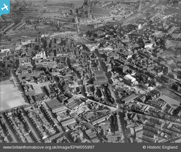
EPW055897 ENGLAND (1937). Peel Street and the town centre, Barnsley, 1937
© Copyright OpenStreetMap contributors and licensed by the OpenStreetMap Foundation. 2026. Cartography is licensed as CC BY-SA.
Nearby Images (18)
Details
| Title | [EPW055897] Peel Street and the town centre, Barnsley, 1937 |
| Reference | EPW055897 |
| Date | 24-October-1937 |
| Link | |
| Place name | BARNSLEY |
| Parish | |
| District | |
| Country | ENGLAND |
| Easting / Northing | 434288, 406373 |
| Longitude / Latitude | -1.4823960325603, 53.552621629378 |
| National Grid Reference | SE343064 |
Pins
Be the first to add a comment to this image!


![[EPW055897] Peel Street and the town centre, Barnsley, 1937](http://britainfromabove.org.uk/sites/all/libraries/aerofilms-images/public/100x100/EPW/055/EPW055897.jpg)
![[EPW021099] Peel Street and Taylor's Linen Mill, Barnsley, 1928](http://britainfromabove.org.uk/sites/all/libraries/aerofilms-images/public/100x100/EPW/021/EPW021099.jpg)
![[EPW048004] The town centre, Barnsley, from the south-west, 1935](http://britainfromabove.org.uk/sites/all/libraries/aerofilms-images/public/100x100/EPW/048/EPW048004.jpg)
![[EAW024171] The town centre, Barnsley, 1949](http://britainfromabove.org.uk/sites/all/libraries/aerofilms-images/public/100x100/EAW/024/EAW024171.jpg)
![[EPW057290] The Town Hall, Barnsley, 1938](http://britainfromabove.org.uk/sites/all/libraries/aerofilms-images/public/100x100/EPW/057/EPW057290.jpg)
![[EPW061491] The town centre, Barnsley, 1939](http://britainfromabove.org.uk/sites/all/libraries/aerofilms-images/public/100x100/EPW/061/EPW061491.jpg)
![[EPW055899] The Town Hall and environs, Barnsley, 1937](http://britainfromabove.org.uk/sites/all/libraries/aerofilms-images/public/100x100/EPW/055/EPW055899.jpg)
![[EPW057291] The town centre, Barnsley, 1938](http://britainfromabove.org.uk/sites/all/libraries/aerofilms-images/public/100x100/EPW/057/EPW057291.jpg)
![[EPW021103] Town End and environs, Barnsley, 1928](http://britainfromabove.org.uk/sites/all/libraries/aerofilms-images/public/100x100/EPW/021/EPW021103.jpg)
![[EPW057292] The town centre, Barnsley, 1938](http://britainfromabove.org.uk/sites/all/libraries/aerofilms-images/public/100x100/EPW/057/EPW057292.jpg)
![[EPW021100] Town End and The Pavilion Picture Theatre, Barnsley, 1928](http://britainfromabove.org.uk/sites/all/libraries/aerofilms-images/public/100x100/EPW/021/EPW021100.jpg)
![[EPW055898] The Town Hall and environs, Barnsley, 1937](http://britainfromabove.org.uk/sites/all/libraries/aerofilms-images/public/100x100/EPW/055/EPW055898.jpg)
![[EAW024172] The town centre, Barnsley, 1949](http://britainfromabove.org.uk/sites/all/libraries/aerofilms-images/public/100x100/EAW/024/EAW024172.jpg)
![[EPW057294] The town centre, Barnsley, 1938](http://britainfromabove.org.uk/sites/all/libraries/aerofilms-images/public/100x100/EPW/057/EPW057294.jpg)
![[EPW057293] The town centre, Barnsley, 1938](http://britainfromabove.org.uk/sites/all/libraries/aerofilms-images/public/100x100/EPW/057/EPW057293.jpg)
![[EPW061490] The town centre, Barnsley, 1939](http://britainfromabove.org.uk/sites/all/libraries/aerofilms-images/public/100x100/EPW/061/EPW061490.jpg)
![[EPW021097] The Town Centre, Barnsley, 1928](http://britainfromabove.org.uk/sites/all/libraries/aerofilms-images/public/100x100/EPW/021/EPW021097.jpg)
![[EPW061492] The town centre, Barnsley, from the north-west, 1939](http://britainfromabove.org.uk/sites/all/libraries/aerofilms-images/public/100x100/EPW/061/EPW061492.jpg)