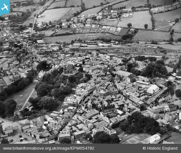
EPW054782 ENGLAND (1937). The castle and town, Launceston, 1937
© Copyright OpenStreetMap contributors and licensed by the OpenStreetMap Foundation. 2026. Cartography is licensed as CC BY-SA.
Nearby Images (17)
Details
| Title | [EPW054782] The castle and town, Launceston, 1937 |
| Reference | EPW054782 |
| Date | August-1937 |
| Link | |
| Place name | LAUNCESTON |
| Parish | LAUNCESTON |
| District | |
| Country | ENGLAND |
| Easting / Northing | 233144, 84679 |
| Longitude / Latitude | -4.3599037930016, 50.637303865776 |
| National Grid Reference | SX331847 |
Pins
Lynda Tubbs |
Tuesday 3rd of December 2013 12:34:59 PM | |
Lynda Tubbs |
Tuesday 3rd of December 2013 12:23:24 PM | |

MB |
Thursday 7th of November 2013 06:22:41 PM | |

MB |
Thursday 7th of November 2013 06:21:59 PM | |

MB |
Thursday 7th of November 2013 06:21:36 PM | |

MB |
Thursday 7th of November 2013 06:20:58 PM | |

MB |
Thursday 7th of November 2013 06:20:18 PM | |

MB |
Thursday 7th of November 2013 06:19:45 PM | |

MB |
Thursday 7th of November 2013 06:18:35 PM |


![[EPW054782] The castle and town, Launceston, 1937](http://britainfromabove.org.uk/sites/all/libraries/aerofilms-images/public/100x100/EPW/054/EPW054782.jpg)
![[EAW005837] The castle and town, Launceston, 1947](http://britainfromabove.org.uk/sites/all/libraries/aerofilms-images/public/100x100/EAW/005/EAW005837.jpg)
![[EAW005838] The castle and town, Launceston, 1947. This image has been produced from a print.](http://britainfromabove.org.uk/sites/all/libraries/aerofilms-images/public/100x100/EAW/005/EAW005838.jpg)
![[EPW054781] The castle and town, Launceston, 1937](http://britainfromabove.org.uk/sites/all/libraries/aerofilms-images/public/100x100/EPW/054/EPW054781.jpg)
![[EAW014993] Launceston Castle and the town centre, Launceston, 1948. This image has been produced from a print.](http://britainfromabove.org.uk/sites/all/libraries/aerofilms-images/public/100x100/EAW/014/EAW014993.jpg)
![[EAW005835] The castle, Launceston, 1947. This image has been produced from a print.](http://britainfromabove.org.uk/sites/all/libraries/aerofilms-images/public/100x100/EAW/005/EAW005835.jpg)
![[EAW005834] The castle, Launceston, 1947. This image has been produced from a print.](http://britainfromabove.org.uk/sites/all/libraries/aerofilms-images/public/100x100/EAW/005/EAW005834.jpg)
![[EAW014992] Launceston Castle and the town centre, Launceston, 1948. This image has been produced from a print.](http://britainfromabove.org.uk/sites/all/libraries/aerofilms-images/public/100x100/EAW/014/EAW014992.jpg)
![[EPW023643] Launceston Castle, Launceston, 1928](http://britainfromabove.org.uk/sites/all/libraries/aerofilms-images/public/100x100/EPW/023/EPW023643.jpg)
![[EAW005836] The castle and town, Launceston, 1947. This image has been produced from a print.](http://britainfromabove.org.uk/sites/all/libraries/aerofilms-images/public/100x100/EAW/005/EAW005836.jpg)
![[EPW023650] The town, Launceston, 1928. This image has been produced from a copy-negative.](http://britainfromabove.org.uk/sites/all/libraries/aerofilms-images/public/100x100/EPW/023/EPW023650.jpg)
![[EAW014991] Launceston Castle above the town, Launceston, 1948. This image has been produced from a print.](http://britainfromabove.org.uk/sites/all/libraries/aerofilms-images/public/100x100/EAW/014/EAW014991.jpg)
![[EPW023648] The War Memorial, Launceston, 1928](http://britainfromabove.org.uk/sites/all/libraries/aerofilms-images/public/100x100/EPW/023/EPW023648.jpg)
![[EPW023649] The War Memorial, Launceston, 1928](http://britainfromabove.org.uk/sites/all/libraries/aerofilms-images/public/100x100/EPW/023/EPW023649.jpg)
![[EPW054779] The town centre including the castle, Launceston, 1937](http://britainfromabove.org.uk/sites/all/libraries/aerofilms-images/public/100x100/EPW/054/EPW054779.jpg)
![[EPW011305] The town, Launceston, 1924. This image has been produced from a print.](http://britainfromabove.org.uk/sites/all/libraries/aerofilms-images/public/100x100/EPW/011/EPW011305.jpg)
![[EPW023644] St Thomas Hill, Launceston, from the north-west, 1928](http://britainfromabove.org.uk/sites/all/libraries/aerofilms-images/public/100x100/EPW/023/EPW023644.jpg)