
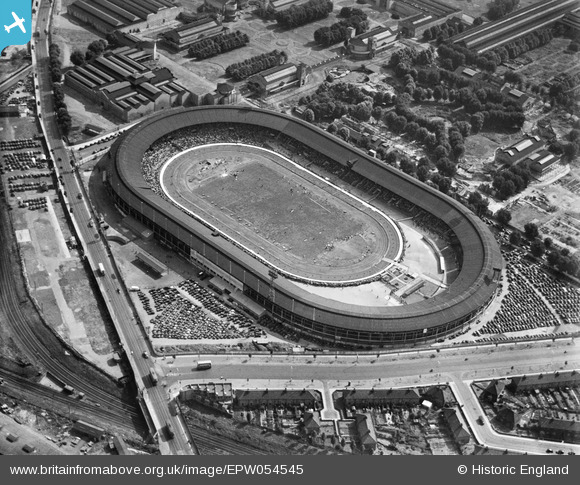
EPW054545 ENGLAND (1937). Shepherd's Bush, the International Athletics Meeting at the White City Stadium, 1937
© Copyright OpenStreetMap contributors and licensed by the OpenStreetMap Foundation. 2026. Cartography is licensed as CC BY-SA.
Nearby Images (48)
EPW054545

EPW031078

EPW046819

EPW042217
, 1933")
EPW031082

EPW036465

EPW031079

EPW054547

EPW036470

EPW054548

EPW031086

EPW054550

EPW036464

EPW053787

EPW031083

EPW054551

EPW031077

EPW036469

EPW022644

EPW036468

EPW054546

EPW042221
, 1933")
EPW022641

EPW022643

EPW036473

EPW031087

EPW022642

EPW031084

EPW036466

EPW053795

EPW054549

EPW056836

EPW053782

EPW031085

EPW022639

EPW022638

EPW042220
, 1933")
EPW031081

EPW042222
, 1933")
EPW042223
, 1933")
EPW053792

EPW021262

EPW021263

EPW019018

EPW042219
, 1933")
EPW062153

EAW005414

EAW005407

Details
| Title | [EPW054545] Shepherd's Bush, the International Athletics Meeting at the White City Stadium, 1937 |
| Reference | EPW054545 |
| Date | 2-August-1937 |
| Link | |
| Place name | SHEPHERD'S BUSH |
| Parish | |
| District | |
| Country | ENGLAND |
| Easting / Northing | 523086, 180915 |
| Longitude / Latitude | -0.2260036239391, 51.513252615656 |
| National Grid Reference | TQ231809 |
Pins

bondi |
Sunday 8th of November 2015 05:54:09 PM |