
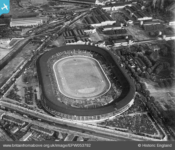
EPW053782 ENGLAND (1937). Shepherd's Bush, crowds gathering within the White City Stadium for a Greyhound Race Meeting, 1937
© Copyright OpenStreetMap contributors and licensed by the OpenStreetMap Foundation. 2026. Cartography is licensed as CC BY-SA.
Nearby Images (48)
EPW053782

EPW031077

EPW036473

EPW053787

EPW053795

EPW056836

EPW022643

EPW054547

EPW031082

EPW031085

EPW046819

EPW031078

EPW054550

EPW022641

EPW031079

EPW031083

EPW022644

EPW036469

EPW054545

EPW042217
, 1933")
EPW054551

EPW036470

EPW036468

EPW022642

EPW036465

EPW042221
, 1933")
EPW031086

EPW054548

EPW036466

EPW036464

EPW062153

EPW054546

EPW031084

EPW021262

EPW031087

EPW022639

EPW042219
, 1933")
EPW042220
, 1933")
EPW054549

EPW019018

EPW021263

EPW042222
, 1933")
EPW031081

EPW042223
, 1933")
EAW005414

EPW053792

EAW005407

EPW005725

Details
| Title | [EPW053782] Shepherd's Bush, crowds gathering within the White City Stadium for a Greyhound Race Meeting, 1937 |
| Reference | EPW053782 |
| Date | 26-July-1937 |
| Link | |
| Place name | SHEPHERD'S BUSH |
| Parish | |
| District | |
| Country | ENGLAND |
| Easting / Northing | 523104, 180849 |
| Longitude / Latitude | -0.22576738216244, 51.512655473771 |
| National Grid Reference | TQ231808 |
Pins

bondi |
Sunday 8th of November 2015 05:38:29 PM |