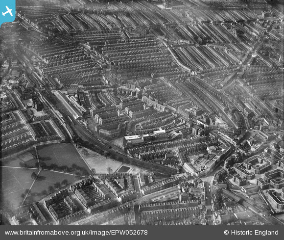
EPW052678 ENGLAND (1937). Fulham Court and surrounding residential area, Fulham, 1937
© Copyright OpenStreetMap contributors and licensed by the OpenStreetMap Foundation. 2026. Cartography is licensed as CC BY-SA.
Nearby Images (15)
Details
| Title | [EPW052678] Fulham Court and surrounding residential area, Fulham, 1937 |
| Reference | EPW052678 |
| Date | 12-March-1937 |
| Link | |
| Place name | FULHAM |
| Parish | |
| District | |
| Country | ENGLAND |
| Easting / Northing | 525143, 177010 |
| Longitude / Latitude | -0.19775755591934, 51.47770227958 |
| National Grid Reference | TQ251770 |
Pins

ap493 |
Monday 29th of March 2021 03:05:54 PM | |

Robin |
Monday 4th of January 2021 11:21:11 PM | |

Class31 |
Tuesday 9th of September 2014 03:15:07 PM | |

Class31 |
Tuesday 9th of September 2014 03:10:08 PM | |

Class31 |
Tuesday 9th of September 2014 03:09:08 PM | |

Class31 |
Tuesday 9th of September 2014 03:06:10 PM | |

Class31 |
Tuesday 9th of September 2014 03:05:10 PM | |

Class31 |
Tuesday 9th of September 2014 03:03:48 PM |


![[EPW052678] Fulham Court and surrounding residential area, Fulham, 1937](http://britainfromabove.org.uk/sites/all/libraries/aerofilms-images/public/100x100/EPW/052/EPW052678.jpg)
![[EPW052668] Fulham Court and environs, Fulham, 1937](http://britainfromabove.org.uk/sites/all/libraries/aerofilms-images/public/100x100/EPW/052/EPW052668.jpg)
![[EPW052670] Fulham Court, Fulham, 1937](http://britainfromabove.org.uk/sites/all/libraries/aerofilms-images/public/100x100/EPW/052/EPW052670.jpg)
![[EPW052673] Fulham Court and environs, Fulham, 1937](http://britainfromabove.org.uk/sites/all/libraries/aerofilms-images/public/100x100/EPW/052/EPW052673.jpg)
![[EPW052676] Fulham Court and surrounding residential area, Fulham, 1937](http://britainfromabove.org.uk/sites/all/libraries/aerofilms-images/public/100x100/EPW/052/EPW052676.jpg)
![[EPW052671] Fulham Court, Fulham, 1937](http://britainfromabove.org.uk/sites/all/libraries/aerofilms-images/public/100x100/EPW/052/EPW052671.jpg)
![[EPW052672] Fulham Court and environs, Fulham, 1937](http://britainfromabove.org.uk/sites/all/libraries/aerofilms-images/public/100x100/EPW/052/EPW052672.jpg)
![[EPW052669] Fulham Court and environs, Fulham, 1937](http://britainfromabove.org.uk/sites/all/libraries/aerofilms-images/public/100x100/EPW/052/EPW052669.jpg)
![[EPW025108] The Swan Brewery (City of London Brewery), Fulham, 1928](http://britainfromabove.org.uk/sites/all/libraries/aerofilms-images/public/100x100/EPW/025/EPW025108.jpg)
![[EPW052666] Fulham Court and environs, Fulham, 1937](http://britainfromabove.org.uk/sites/all/libraries/aerofilms-images/public/100x100/EPW/052/EPW052666.jpg)
![[EPW052675] Fulham Court and surrounding residential area, Fulham, 1937](http://britainfromabove.org.uk/sites/all/libraries/aerofilms-images/public/100x100/EPW/052/EPW052675.jpg)
![[EPW052667] Fulham Court and environs, Fulham, 1937](http://britainfromabove.org.uk/sites/all/libraries/aerofilms-images/public/100x100/EPW/052/EPW052667.jpg)
![[EPW052679] Eel Brook Common, Sands End and environs, Fulham, from the north-west, 1937](http://britainfromabove.org.uk/sites/all/libraries/aerofilms-images/public/100x100/EPW/052/EPW052679.jpg)
![[EPW052674] Fulham Court and surrounding residential area, Fulham, from the south-east, 1937](http://britainfromabove.org.uk/sites/all/libraries/aerofilms-images/public/100x100/EPW/052/EPW052674.jpg)
![[EPW052677] Eel Brook Common, Sands End and environs, Parsons Green, 1937](http://britainfromabove.org.uk/sites/all/libraries/aerofilms-images/public/100x100/EPW/052/EPW052677.jpg)