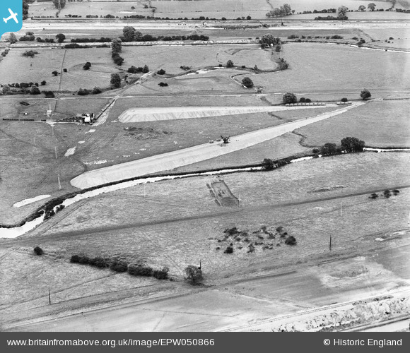
EPW050866 ENGLAND (1936). The site of the William Girling Reservoir showing preliminary construction works, Edmonton, 1936
© Copyright OpenStreetMap contributors and licensed by the OpenStreetMap Foundation. 2026. Cartography is licensed as CC BY-SA.
Nearby Images (24)
Details
| Title | [EPW050866] The site of the William Girling Reservoir showing preliminary construction works, Edmonton, 1936 |
| Reference | EPW050866 |
| Date | July-1936 |
| Link | |
| Place name | EDMONTON |
| Parish | |
| District | |
| Country | ENGLAND |
| Easting / Northing | 536684, 194605 |
| Longitude / Latitude | -0.024811767474163, 51.633159000598 |
| National Grid Reference | TQ367946 |
Pins
Be the first to add a comment to this image!


![[EPW050866] The site of the William Girling Reservoir showing preliminary construction works, Edmonton, 1936](http://britainfromabove.org.uk/sites/all/libraries/aerofilms-images/public/100x100/EPW/050/EPW050866.jpg)
![[EPW052277] The site of William Girling Reservoir showing preliminary construction works, Edmonton, 1936](http://britainfromabove.org.uk/sites/all/libraries/aerofilms-images/public/100x100/EPW/052/EPW052277.jpg)
![[EPW056331] The William Girling Reservoir under construction, Edmonton, 1938](http://britainfromabove.org.uk/sites/all/libraries/aerofilms-images/public/100x100/EPW/056/EPW056331.jpg)
![[EPW058464] The northern part of the Chingford (William Girling) Reservoir under construction, Edmonton, 1938](http://britainfromabove.org.uk/sites/all/libraries/aerofilms-images/public/100x100/EPW/058/EPW058464.jpg)
![[EPW048905] The Enfield Council Sewage Farm alongside the site of the William Girling Reservoir, Ponders End, 1935](http://britainfromabove.org.uk/sites/all/libraries/aerofilms-images/public/100x100/EPW/048/EPW048905.jpg)
![[EPW056811] The William Girling Reservoir under construction, Edmonton, 1938](http://britainfromabove.org.uk/sites/all/libraries/aerofilms-images/public/100x100/EPW/056/EPW056811.jpg)
![[EPW049694] The site of the northern end of the William Girling Reservoir showing preliminary construction works, Ponders End, 1936](http://britainfromabove.org.uk/sites/all/libraries/aerofilms-images/public/100x100/EPW/049/EPW049694.jpg)
![[EPW049695] The site of the northern end of the William Girling Reservoir showing preliminary construction works, Ponders End, 1936](http://britainfromabove.org.uk/sites/all/libraries/aerofilms-images/public/100x100/EPW/049/EPW049695.jpg)
![[EPW056332] The William Girling Reservoir under construction, Edmonton, 1938](http://britainfromabove.org.uk/sites/all/libraries/aerofilms-images/public/100x100/EPW/056/EPW056332.jpg)
![[EPW055976] The northern section of the William Girling Reservoir under construction, Enfield, 1937](http://britainfromabove.org.uk/sites/all/libraries/aerofilms-images/public/100x100/EPW/055/EPW055976.jpg)
![[EPW053846] The northern part of the Chingford (William Girling) Reservoir under construction, Edmonton, 1937](http://britainfromabove.org.uk/sites/all/libraries/aerofilms-images/public/100x100/EPW/053/EPW053846.jpg)
![[EPW052278] The site of the northern end of the William Girling Reservoir showing preliminary construction works, Ponders End, 1936. This image has been produced from a damaged negative.](http://britainfromabove.org.uk/sites/all/libraries/aerofilms-images/public/100x100/EPW/052/EPW052278.jpg)
![[EAW040971] The William Girling Reservoir, Enfield, 1951](http://britainfromabove.org.uk/sites/all/libraries/aerofilms-images/public/100x100/EAW/040/EAW040971.jpg)
![[EPW050858] The site of the William Girling Reservoir, Edmonton, 1936](http://britainfromabove.org.uk/sites/all/libraries/aerofilms-images/public/100x100/EPW/050/EPW050858.jpg)
![[EPW060222] The Chingford (William Girling) Reservoir under construction, Edmonton, 1938](http://britainfromabove.org.uk/sites/all/libraries/aerofilms-images/public/100x100/EPW/060/EPW060222.jpg)
![[EPW060639] The William Girling Reservoir under construction, Enfield, 1939](http://britainfromabove.org.uk/sites/all/libraries/aerofilms-images/public/100x100/EPW/060/EPW060639.jpg)
![[EPW055971] The northern section of the William Girling Reservoir under construction, Enfield, 1937](http://britainfromabove.org.uk/sites/all/libraries/aerofilms-images/public/100x100/EPW/055/EPW055971.jpg)
![[EPW060630] Lea Valley Road and the William Girling Reservoir under construction, Enfield, 1939](http://britainfromabove.org.uk/sites/all/libraries/aerofilms-images/public/100x100/EPW/060/EPW060630.jpg)
![[EPW053854] The Chingford (William Girling) Reservoir under construction, Edmonton, 1937](http://britainfromabove.org.uk/sites/all/libraries/aerofilms-images/public/100x100/EPW/053/EPW053854.jpg)
![[EPW056813] The William Girling Reservoir under construction, Edmonton, 1938](http://britainfromabove.org.uk/sites/all/libraries/aerofilms-images/public/100x100/EPW/056/EPW056813.jpg)
![[EPW058456] The northern part of the Chingford (William Girling) Reservoir under construction, Edmonton, 1938](http://britainfromabove.org.uk/sites/all/libraries/aerofilms-images/public/100x100/EPW/058/EPW058456.jpg)
![[EPW049524] Site of the William Girling Reservoir, Enfield, 1935](http://britainfromabove.org.uk/sites/all/libraries/aerofilms-images/public/100x100/EPW/049/EPW049524.jpg)
![[EAW040926] The recently completed William Girling Reservoir beginning to fill up with water, Edmonton, 1951](http://britainfromabove.org.uk/sites/all/libraries/aerofilms-images/public/100x100/EAW/040/EAW040926.jpg)
![[EPW058462] The northern part of the Chingford (William Girling) Reservoir under construction, Edmonton, 1938](http://britainfromabove.org.uk/sites/all/libraries/aerofilms-images/public/100x100/EPW/058/EPW058462.jpg)