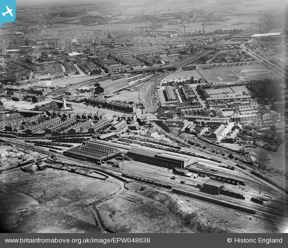
EPW048638 ENGLAND (1935). The Buckley Wells railway depot and environs, Bury, from the west, 1935
© Copyright OpenStreetMap contributors and licensed by the OpenStreetMap Foundation. 2026. Cartography is licensed as CC BY-SA.
Nearby Images (9)
Details
| Title | [EPW048638] The Buckley Wells railway depot and environs, Bury, from the west, 1935 |
| Reference | EPW048638 |
| Date | July-1935 |
| Link | |
| Place name | BURY |
| Parish | |
| District | |
| Country | ENGLAND |
| Easting / Northing | 379964, 410133 |
| Longitude / Latitude | -2.3027047095683, 53.587158657402 |
| National Grid Reference | SD800101 |
Pins
User Comment Contributions
Lancashire Fusiliers Boer War, War Memorial, Whitehead Gardens, Bury, 25/08/2014 |

Class31 |
Wednesday 15th of October 2014 04:20:47 PM |


![[EPW048638] The Buckley Wells railway depot and environs, Bury, from the west, 1935](http://britainfromabove.org.uk/sites/all/libraries/aerofilms-images/public/100x100/EPW/048/EPW048638.jpg)
![[EPW048640] The Buckley Wells railway depot and environs, Bury, from the west, 1935](http://britainfromabove.org.uk/sites/all/libraries/aerofilms-images/public/100x100/EPW/048/EPW048640.jpg)
![[EPW047494] The Buckley Wells railway depot and the town, Bury, from the west, 1935](http://britainfromabove.org.uk/sites/all/libraries/aerofilms-images/public/100x100/EPW/047/EPW047494.jpg)
![[EPW048657] The Buckley Wells railway depot and environs, Bury, from the west, 1935](http://britainfromabove.org.uk/sites/all/libraries/aerofilms-images/public/100x100/EPW/048/EPW048657.jpg)
![[EPW048642] The Buckley Wells railway depot and environs, Bury, from the west, 1935](http://britainfromabove.org.uk/sites/all/libraries/aerofilms-images/public/100x100/EPW/048/EPW048642.jpg)
![[EPW047496] Buckley Wells and environs, Bury, from the west, 1935](http://britainfromabove.org.uk/sites/all/libraries/aerofilms-images/public/100x100/EPW/047/EPW047496.jpg)
![[EPW047493] Knowsley Street Station and the town, Bury, from the west, 1935](http://britainfromabove.org.uk/sites/all/libraries/aerofilms-images/public/100x100/EPW/047/EPW047493.jpg)
![[EPW046164] The Buckley Wells Carriage Shed, the Whitehead Clock Tower and environs, Bury, 1934](http://britainfromabove.org.uk/sites/all/libraries/aerofilms-images/public/100x100/EPW/046/EPW046164.jpg)
![[EPW047495] The Buckley Wells railway depot and the town, Bury, from the west, 1935](http://britainfromabove.org.uk/sites/all/libraries/aerofilms-images/public/100x100/EPW/047/EPW047495.jpg)
