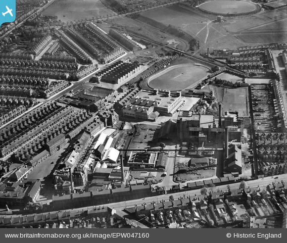
EPW047160 ENGLAND (1935). The Cape Hill Brewery and Cricket Ground, Smethwick, 1935
© Copyright OpenStreetMap contributors and licensed by the OpenStreetMap Foundation. 2025. Cartography is licensed as CC BY-SA.
Nearby Images (10)
Details
| Title | [EPW047160] The Cape Hill Brewery and Cricket Ground, Smethwick, 1935 |
| Reference | EPW047160 |
| Date | May-1935 |
| Link | |
| Place name | SMETHWICK |
| Parish | |
| District | |
| Country | ENGLAND |
| Easting / Northing | 403392, 287519 |
| Longitude / Latitude | -1.9500436753855, 52.48521114065 |
| National Grid Reference | SP034875 |


![[EPW047160] The Cape Hill Brewery and Cricket Ground, Smethwick, 1935](http://britainfromabove.org.uk/sites/all/libraries/aerofilms-images/public/100x100/EPW/047/EPW047160.jpg)
![[EPW047163] The Cape Hill Brewery and Cricket Ground, Smethwick, 1935](http://britainfromabove.org.uk/sites/all/libraries/aerofilms-images/public/100x100/EPW/047/EPW047163.jpg)
![[EPW047161] The Cape Hill Brewery and Cricket Ground, Smethwick, 1935](http://britainfromabove.org.uk/sites/all/libraries/aerofilms-images/public/100x100/EPW/047/EPW047161.jpg)
![[EPW047159] The Cape Hill Brewery and Cricket Ground, Smethwick, 1935](http://britainfromabove.org.uk/sites/all/libraries/aerofilms-images/public/100x100/EPW/047/EPW047159.jpg)
![[EPW047166] The Cape Hill Brewery and the surrounding residential area, Smethwick, 1935](http://britainfromabove.org.uk/sites/all/libraries/aerofilms-images/public/100x100/EPW/047/EPW047166.jpg)
![[EPW047167] The Cape Hill Brewery and Cricket Ground, Smethwick, 1935](http://britainfromabove.org.uk/sites/all/libraries/aerofilms-images/public/100x100/EPW/047/EPW047167.jpg)
![[EPW047158] The Cape Hill Brewery and Cricket Ground, Smethwick, 1935](http://britainfromabove.org.uk/sites/all/libraries/aerofilms-images/public/100x100/EPW/047/EPW047158.jpg)
![[EPW047165] The Cape Hill Brewery and the surrounding residential area, Smethwick, 1935](http://britainfromabove.org.uk/sites/all/libraries/aerofilms-images/public/100x100/EPW/047/EPW047165.jpg)
![[EPW047164] The Cape Hill Brewery and the surrounding residential area, Smethwick, 1935](http://britainfromabove.org.uk/sites/all/libraries/aerofilms-images/public/100x100/EPW/047/EPW047164.jpg)
![[EPW047162] The Cape Hill Brewery and Cricket Ground, Smethwick, 1935](http://britainfromabove.org.uk/sites/all/libraries/aerofilms-images/public/100x100/EPW/047/EPW047162.jpg)
