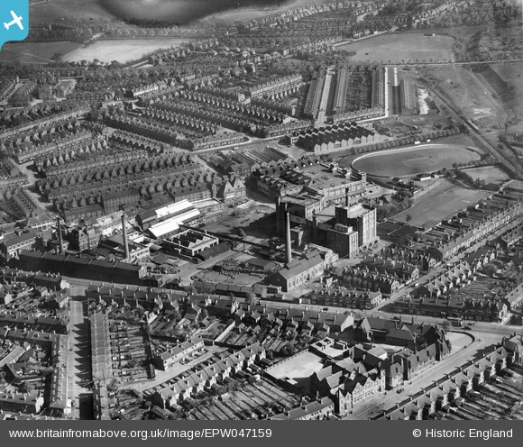
EPW047159 ENGLAND (1935). The Cape Hill Brewery and Cricket Ground, Smethwick, 1935
© Copyright OpenStreetMap contributors and licensed by the OpenStreetMap Foundation. 2025. Cartography is licensed as CC BY-SA.
Nearby Images (10)
Details
| Title | [EPW047159] The Cape Hill Brewery and Cricket Ground, Smethwick, 1935 |
| Reference | EPW047159 |
| Date | May-1935 |
| Link | |
| Place name | SMETHWICK |
| Parish | |
| District | |
| Country | ENGLAND |
| Easting / Northing | 403375, 287537 |
| Longitude / Latitude | -1.9502938635922, 52.485373084024 |
| National Grid Reference | SP034875 |
Pins

Shelsal |
Friday 1st of March 2024 03:02:51 PM | |

Shelsal |
Friday 1st of March 2024 03:00:49 PM | |

Shelsal |
Friday 1st of March 2024 03:00:15 PM | |

Shelsal |
Friday 1st of March 2024 02:59:33 PM | |

Shelsal |
Friday 1st of March 2024 02:58:36 PM | |

HBMil |
Saturday 13th of March 2021 01:26:07 PM | |

Kevin |
Sunday 24th of July 2016 10:32:33 PM | |

Kevin |
Sunday 24th of July 2016 10:29:57 PM | |

Kevin |
Sunday 24th of July 2016 10:27:02 PM | |

Kevin |
Sunday 24th of July 2016 10:24:13 PM | |

Kevin |
Sunday 24th of July 2016 10:23:50 PM | |

Class31 |
Thursday 27th of August 2015 08:43:06 PM | |

Martin |
Tuesday 1st of July 2014 10:20:37 PM | |

PURCELL |
Saturday 17th of May 2014 09:24:52 AM | |

PURCELL |
Saturday 17th of May 2014 09:23:59 AM |


![[EPW047159] The Cape Hill Brewery and Cricket Ground, Smethwick, 1935](http://britainfromabove.org.uk/sites/all/libraries/aerofilms-images/public/100x100/EPW/047/EPW047159.jpg)
![[EPW047160] The Cape Hill Brewery and Cricket Ground, Smethwick, 1935](http://britainfromabove.org.uk/sites/all/libraries/aerofilms-images/public/100x100/EPW/047/EPW047160.jpg)
![[EPW047163] The Cape Hill Brewery and Cricket Ground, Smethwick, 1935](http://britainfromabove.org.uk/sites/all/libraries/aerofilms-images/public/100x100/EPW/047/EPW047163.jpg)
![[EPW047161] The Cape Hill Brewery and Cricket Ground, Smethwick, 1935](http://britainfromabove.org.uk/sites/all/libraries/aerofilms-images/public/100x100/EPW/047/EPW047161.jpg)
![[EPW047166] The Cape Hill Brewery and the surrounding residential area, Smethwick, 1935](http://britainfromabove.org.uk/sites/all/libraries/aerofilms-images/public/100x100/EPW/047/EPW047166.jpg)
![[EPW047167] The Cape Hill Brewery and Cricket Ground, Smethwick, 1935](http://britainfromabove.org.uk/sites/all/libraries/aerofilms-images/public/100x100/EPW/047/EPW047167.jpg)
![[EPW047158] The Cape Hill Brewery and Cricket Ground, Smethwick, 1935](http://britainfromabove.org.uk/sites/all/libraries/aerofilms-images/public/100x100/EPW/047/EPW047158.jpg)
![[EPW047165] The Cape Hill Brewery and the surrounding residential area, Smethwick, 1935](http://britainfromabove.org.uk/sites/all/libraries/aerofilms-images/public/100x100/EPW/047/EPW047165.jpg)
![[EPW047162] The Cape Hill Brewery and Cricket Ground, Smethwick, 1935](http://britainfromabove.org.uk/sites/all/libraries/aerofilms-images/public/100x100/EPW/047/EPW047162.jpg)
![[EPW047164] The Cape Hill Brewery and the surrounding residential area, Smethwick, 1935](http://britainfromabove.org.uk/sites/all/libraries/aerofilms-images/public/100x100/EPW/047/EPW047164.jpg)
