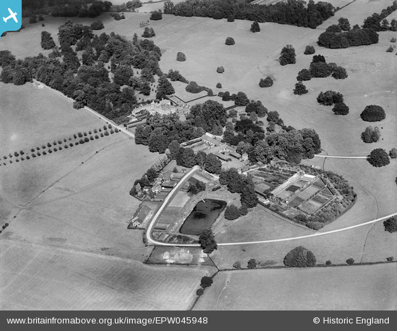
EPW045948 ENGLAND (1934). Albury Hall with the outbuildings, conduit pond and kitchen garden, Albury, 1934

© Copyright OpenStreetMap contributors and licensed by the OpenStreetMap Foundation. 2025. Cartography is licensed as CC BY-SA.

Nearby Images (7)

EPW045948
  0° 0m
EPW045952
  108° 50m
EPW045953
  175° 57m
EPW045949
  223° 73m
EPW045951
  173° 109m
EPW045947
  334° 113m
EPW045954
  341° 162m

Details

Title [EPW045948] Albury Hall with the outbuildings, conduit pond and kitchen garden, Albury, 1934
Reference EPW045948
Date September-1934
Link
Place name ALBURY
Parish ALBURY
District
Country ENGLAND
Easting / Northing 542670, 225416
Longitude / Latitude 0.074289880651272, 51.908547316424
National Grid Reference TL427254

Pins

This triangular area between the two roads was subsequently wooded and named "Suez"

totoro
Friday 2nd of May 2014 09:15:49 PM

totoro
Friday 2nd of May 2014 09:13:34 PM

totoro
Friday 2nd of May 2014 09:13:18 PM
Possibly the third house on the site, built about 1780. This property is not listed, it no longer exists. The Hall was demolished in 1950. There is no record of the reason for its demolition. Image is pre-1912 and came from the photo album of C F Hawley; Courtesy of his grandson, Nicholas Hawley. Photographer is not known and therefore copyright is assumed to have expired. Source: http://www.alburyvillage.org.uk/ Author Anne Padfield compiled an historical survey of the Hall in the year 2000. see http://www.alburyvillage.org.uk/Albury Hall Survey.htm From 1906-c1921 the Hall was owned by Maurice Glyn, a partner of the banking house Glyn Mills Currie and Co (which passed via Williams and Glyns Bank to Royal Bank of Scotland). The hall passed to its final owner, Francis Glyn. When the armed forces moved into the hall in WW2 the Glyn family moved to Hole Farm nearby. The Glyn family sold the estate in 1981.

totoro
Friday 2nd of May 2014 09:06:08 PM