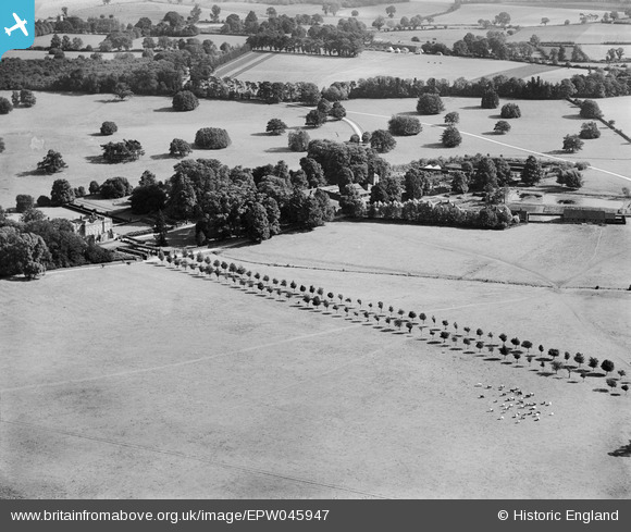
EPW045947 ENGLAND (1934). The avenue of trees at Albury Hall, Albury, 1934

© Copyright OpenStreetMap contributors and licensed by the OpenStreetMap Foundation. 2025. Cartography is licensed as CC BY-SA.

Nearby Images (7)

EPW045947
  0° 0m
EPW045954
  357° 52m
EPW045948
  154° 113m
EPW045952
  140° 152m
EPW045949
  180° 155m
EPW045953
  161° 167m
EPW045951
  163° 219m

Details

Title [EPW045947] The avenue of trees at Albury Hall, Albury, 1934
Reference EPW045947
Date September-1934
Link
Place name ALBURY
Parish ALBURY
District
Country ENGLAND
Easting / Northing 542621, 225518
Longitude / Latitude 0.073620199794465, 51.909476436122
National Grid Reference TL426255

Pins

This triangular area between the two roads was subsequently wooded and named "Suez"

totoro
Friday 2nd of May 2014 09:16:16 PM

totoro
Friday 2nd of May 2014 09:14:04 PM
Possibly the third house on the site, built about 1780. This property is not listed, it no longer exists. The Hall was demolished in 1950. There is no record of the reason for its demolition. Image is pre-1912 and came from the photo album of C F Hawley; Courtesy of his grandson, Nicholas Hawley. Photographer is not known and therefore copyright is assumed to have expired. Source: http://www.alburyvillage.org.uk/ Author Anne Padfield compiled an historical survey of the Hall in the year 2000. see http://www.alburyvillage.org.uk/Albury Hall Survey.htm From 1906-c1921 the Hall was owned by Maurice Glyn, a partner of the banking house Glyn Mills Currie and Co (which passed via Williams and Glyns Bank to Royal Bank of Scotland). The hall passed to its final owner, Francis Glyn. When the armed forces moved into the hall in WW2 the Glyn family moved to Hole Farm nearby. The Glyn family sold the estate in 1981.

totoro
Friday 2nd of May 2014 09:06:44 PM