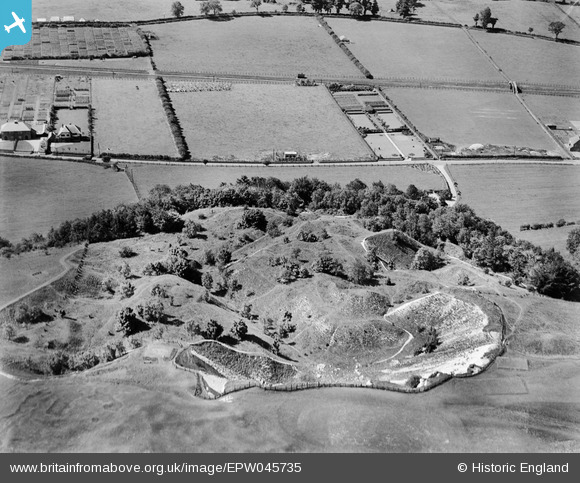
EPW045735 ENGLAND (1934). A disused quarry, Warminster, 1934
© Copyright OpenStreetMap contributors and licensed by the OpenStreetMap Foundation. 2025. Cartography is licensed as CC BY-SA.
Nearby Images (12)
Details
| Title | [EPW045735] A disused quarry, Warminster, 1934 |
| Reference | EPW045735 |
| Date | July-1934 |
| Link | |
| Place name | WARMINSTER |
| Parish | WARMINSTER |
| District | |
| Country | ENGLAND |
| Easting / Northing | 387558, 146001 |
| Longitude / Latitude | -2.1781455323805, 51.212560130293 |
| National Grid Reference | ST876460 |


![[EPW045735] A disused quarry, Warminster, 1934](http://britainfromabove.org.uk/sites/all/libraries/aerofilms-images/public/100x100/EPW/045/EPW045735.jpg)
![[EPW045738] A disused quarry behind Southdown House and surrounding countryside, Warminster, 1934](http://britainfromabove.org.uk/sites/all/libraries/aerofilms-images/public/100x100/EPW/045/EPW045738.jpg)
![[EPW045737] A disused quarry behind Southdown House, Warminster, 1934](http://britainfromabove.org.uk/sites/all/libraries/aerofilms-images/public/100x100/EPW/045/EPW045737.jpg)
![[EPW058915] Southdown house and garden, Warminster, 1938](http://britainfromabove.org.uk/sites/all/libraries/aerofilms-images/public/100x100/EPW/058/EPW058915.jpg)
![[EPW058911] Southdown house and garden, Warminster, 1938](http://britainfromabove.org.uk/sites/all/libraries/aerofilms-images/public/100x100/EPW/058/EPW058911.jpg)
![[EPW045736] Southdown House and environs, Warminster, 1934](http://britainfromabove.org.uk/sites/all/libraries/aerofilms-images/public/100x100/EPW/045/EPW045736.jpg)
![[EPW058910] Southdown house and garden, Warminster, 1938. This image has been affected by flare.](http://britainfromabove.org.uk/sites/all/libraries/aerofilms-images/public/100x100/EPW/058/EPW058910.jpg)
![[EPW058913] Southdown house and garden, Warminster, 1938](http://britainfromabove.org.uk/sites/all/libraries/aerofilms-images/public/100x100/EPW/058/EPW058913.jpg)
![[EPW058914] Southdown house and garden, Warminster, 1938](http://britainfromabove.org.uk/sites/all/libraries/aerofilms-images/public/100x100/EPW/058/EPW058914.jpg)
![[EPW058916] Southdown house and garden, Warminster, 1938](http://britainfromabove.org.uk/sites/all/libraries/aerofilms-images/public/100x100/EPW/058/EPW058916.jpg)
![[EPW058912] Southdown house and garden, Warminster, 1938](http://britainfromabove.org.uk/sites/all/libraries/aerofilms-images/public/100x100/EPW/058/EPW058912.jpg)
![[EPW045734] A disused quarry behind Southdown House and surrounding countryside, Warminster, from the west, 1934](http://britainfromabove.org.uk/sites/all/libraries/aerofilms-images/public/100x100/EPW/045/EPW045734.jpg)
