
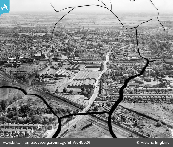
EPW045526 ENGLAND (1934). The Britannia Iron Works and the town, Bedford, from the south-west, 1934. This image has been produced from a damaged negative.
© Copyright OpenStreetMap contributors and licensed by the OpenStreetMap Foundation. 2026. Cartography is licensed as CC BY-SA.
Nearby Images (20)
EPW045526

EAW032052

EAW032061

EAW032055

EPW046441

EPW046432

EPW022385

EPW026475

EPW046442

EAW032063

EAW032058

EAW032059

EPW045528

EAW003720

EAW032051

EPW045525

EPW045530

EAW032060

EAW032054

EAW032053

Details
| Title | [EPW045526] The Britannia Iron Works and the town, Bedford, from the south-west, 1934. This image has been produced from a damaged negative. |
| Reference | EPW045526 |
| Date | July-1934 |
| Link | |
| Place name | BEDFORD |
| Parish | |
| District | |
| Country | ENGLAND |
| Easting / Northing | 504387, 248819 |
| Longitude / Latitude | -0.47492066019818, 52.127398066816 |
| National Grid Reference | TL044488 |
Pins

andrewmawson |
Thursday 10th of December 2015 01:36:30 AM | |

melgibbs |
Monday 13th of January 2014 07:10:14 PM | |
|
melgibbs |
Monday 13th of January 2014 07:07:51 PM | |
Goods train hauled by one of the L.M.S.railway company's giant 2-6-0 0-6-2 Beyer Garratt's. http://en.wikipedia.org/wiki/LMS_Garratt There could be 100+ wagons on this train. |
John Wass |
Wednesday 17th of September 2014 09:24:46 PM |
|
melgibbs |
Thursday 5th of December 2013 07:46:47 PM | |
|
melgibbs |
Thursday 5th of December 2013 07:46:20 PM |