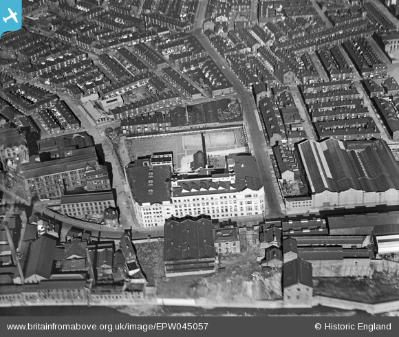
EPW045057 ENGLAND (1934). The E Griffiths Hughes Chemical Works, Salford, 1934
© Copyright OpenStreetMap contributors and licensed by the OpenStreetMap Foundation. 2026. Cartography is licensed as CC BY-SA.
Nearby Images (16)
Details
| Title | [EPW045057] The E Griffiths Hughes Chemical Works, Salford, 1934 |
| Reference | EPW045057 |
| Date | June-1934 |
| Link | |
| Place name | SALFORD |
| Parish | |
| District | |
| Country | ENGLAND |
| Easting / Northing | 382591, 398872 |
| Longitude / Latitude | -2.2623897773769, 53.486023838354 |
| National Grid Reference | SJ826989 |
Pins

Bottom Yard |
Saturday 2nd of March 2019 05:34:55 PM | |

boltie |
Monday 28th of March 2016 06:13:43 PM | |
NOPE, THIS WAS THE FREEMASON'S HALL. |

Bottom Yard |
Saturday 2nd of March 2019 04:53:27 PM |
NOPE, THIS WAS THE FREEMASON'S HALL. |

Bottom Yard |
Saturday 2nd of March 2019 05:34:13 PM |


![[EPW045057] The E Griffiths Hughes Chemical Works, Salford, 1934](http://britainfromabove.org.uk/sites/all/libraries/aerofilms-images/public/100x100/EPW/045/EPW045057.jpg)
![[EPW045056] The E Griffiths Hughes Chemical Works, Salford, 1934](http://britainfromabove.org.uk/sites/all/libraries/aerofilms-images/public/100x100/EPW/045/EPW045056.jpg)
![[EPW045054] The E Griffiths Hughes Chemical Works and environs, Salford, 1934](http://britainfromabove.org.uk/sites/all/libraries/aerofilms-images/public/100x100/EPW/045/EPW045054.jpg)
![[EPW045059] The E Griffiths Hughes Chemical Works, the Adelphi Iron Works and environs, Salford, 1934](http://britainfromabove.org.uk/sites/all/libraries/aerofilms-images/public/100x100/EPW/045/EPW045059.jpg)
![[EAW039822] The Adelphi Iron Works, E Griffiths Hughes Chemical Factory and environs, Salford, 1951.This image was marked by Aerofilms Ltd for photo editing.](http://britainfromabove.org.uk/sites/all/libraries/aerofilms-images/public/100x100/EAW/039/EAW039822.jpg)
![[EPW045055] The E Griffiths Hughes Chemical Works and environs, Salford, 1934. This image was marked by Aerofilms Ltd for photo editing.](http://britainfromabove.org.uk/sites/all/libraries/aerofilms-images/public/100x100/EPW/045/EPW045055.jpg)
![[EAW039820] The Adelphi Iron Works, E Griffiths Hughes Chemical Factory, the River Irwell and environs, Salford, 1951.This image was marked by Aerofilms Ltd for photo editing.](http://britainfromabove.org.uk/sites/all/libraries/aerofilms-images/public/100x100/EAW/039/EAW039820.jpg)
![[EAW039825] The Adelphi Iron Works and the E Griffiths Hughes Chemical Factory, Salford, 1951.This image was marked by Aerofilms Ltd for photo editing.](http://britainfromabove.org.uk/sites/all/libraries/aerofilms-images/public/100x100/EAW/039/EAW039825.jpg)
![[EAW039821] The Adelphi Iron Works, E Griffiths Hughes Chemical Factory and environs, Salford, 1951.This image was marked by Aerofilms Ltd for photo editing.](http://britainfromabove.org.uk/sites/all/libraries/aerofilms-images/public/100x100/EAW/039/EAW039821.jpg)
![[EAW039819] The Adelephi Iron Works, E Griffiths Hughes Chemical Factory and environs, Salford, 1951.This image was marked by Aerofilms Ltd for photo editing.](http://britainfromabove.org.uk/sites/all/libraries/aerofilms-images/public/100x100/EAW/039/EAW039819.jpg)
![[EPW045058] The E Griffiths Hughes Chemical Works, the Adelphi Iron Works and environs, Salford, 1934](http://britainfromabove.org.uk/sites/all/libraries/aerofilms-images/public/100x100/EPW/045/EPW045058.jpg)
![[EAW039827] The Adelphi Iron Works, the E Griffiths Hughes Chemical Factory and environs, Salford, 1951.This image was marked by Aerofilms Ltd for photo editing.](http://britainfromabove.org.uk/sites/all/libraries/aerofilms-images/public/100x100/EAW/039/EAW039827.jpg)
![[EAW039826] The Adelphi Iron Works, the E Griffiths Hughes Chemical Factory and environs, Salford, 1951.This image was marked by Aerofilms Ltd for photo editing.](http://britainfromabove.org.uk/sites/all/libraries/aerofilms-images/public/100x100/EAW/039/EAW039826.jpg)
![[EAW039818] The Adelphi Iron Works, E Griffiths Hughes Chemical Factory and environs, Salford, 1951.This image was marked by Aerofilms Ltd for photo editing.](http://britainfromabove.org.uk/sites/all/libraries/aerofilms-images/public/100x100/EAW/039/EAW039818.jpg)
![[EAW039824] The Adelphi Iron Works, E Griffiths Hughes Chemical Factory and the River Irwell, Salford, 1951.This image was marked by Aerofilms Ltd for photo editing.](http://britainfromabove.org.uk/sites/all/libraries/aerofilms-images/public/100x100/EAW/039/EAW039824.jpg)
![[EAW039823] The Adelphi Iron Works, E Griffiths Hughes Chemical Factory and Peel Park, Salford, 1951.This image was marked by Aerofilms Ltd for photo editing.](http://britainfromabove.org.uk/sites/all/libraries/aerofilms-images/public/100x100/EAW/039/EAW039823.jpg)