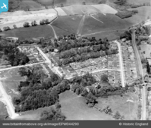
EPW044290 ENGLAND (1934). Housing development at Lambarde Road and environs, Sevenoaks, 1934
© Copyright OpenStreetMap contributors and licensed by the OpenStreetMap Foundation. 2025. Cartography is licensed as CC BY-SA.
Nearby Images (9)
Details
| Title | [EPW044290] Housing development at Lambarde Road and environs, Sevenoaks, 1934 |
| Reference | EPW044290 |
| Date | May-1934 |
| Link | |
| Place name | SEVENOAKS |
| Parish | SEVENOAKS |
| District | |
| Country | ENGLAND |
| Easting / Northing | 552220, 156201 |
| Longitude / Latitude | 0.18299454320735, 51.284071443693 |
| National Grid Reference | TQ522562 |
Pins
Be the first to add a comment to this image!


![[EPW044290] Housing development at Lambarde Road and environs, Sevenoaks, 1934](http://britainfromabove.org.uk/sites/all/libraries/aerofilms-images/public/100x100/EPW/044/EPW044290.jpg)
![[EPW044288] Housing development at Lambarde Road and environs, Sevenoaks, 1934](http://britainfromabove.org.uk/sites/all/libraries/aerofilms-images/public/100x100/EPW/044/EPW044288.jpg)
![[EPW044289] Housing development at Oakdene Road and environs, Sevenoaks, 1934](http://britainfromabove.org.uk/sites/all/libraries/aerofilms-images/public/100x100/EPW/044/EPW044289.jpg)
![[EPW044291] Housing development at Oakdene Road and environs, Sevenoaks, 1934](http://britainfromabove.org.uk/sites/all/libraries/aerofilms-images/public/100x100/EPW/044/EPW044291.jpg)
![[EPW044286] Housing development at Lambarde Road and environs, Sevenoaks, 1934](http://britainfromabove.org.uk/sites/all/libraries/aerofilms-images/public/100x100/EPW/044/EPW044286.jpg)
![[EPW044287] Housing development at Oakdene Road and environs, Sevenoaks, 1934](http://britainfromabove.org.uk/sites/all/libraries/aerofilms-images/public/100x100/EPW/044/EPW044287.jpg)
![[EPW038238] Oakdene Road and environs, Sevenoaks, 1932](http://britainfromabove.org.uk/sites/all/libraries/aerofilms-images/public/100x100/EPW/038/EPW038238.jpg)
![[EPW038241] Woodside Road, construction of new housing at Oakdene Road and environs, Sevenoaks, 1932](http://britainfromabove.org.uk/sites/all/libraries/aerofilms-images/public/100x100/EPW/038/EPW038241.jpg)
![[EPW038243] The area around Sevenoaks Railway Station and construction of new housing at Bosville Drive, Sevenoaks, 1932](http://britainfromabove.org.uk/sites/all/libraries/aerofilms-images/public/100x100/EPW/038/EPW038243.jpg)