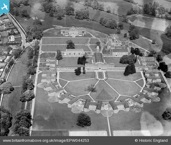
EPW044253 ENGLAND (1934). The Royal Masonic School for Girls, Rickmansworth, 1934
© Copyright OpenStreetMap contributors and licensed by the OpenStreetMap Foundation. 2026. Cartography is licensed as CC BY-SA.
Nearby Images (18)
Details
| Title | [EPW044253] The Royal Masonic School for Girls, Rickmansworth, 1934 |
| Reference | EPW044253 |
| Date | May-1934 |
| Link | |
| Place name | RICKMANSWORTH |
| Parish | |
| District | |
| Country | ENGLAND |
| Easting / Northing | 505689, 195419 |
| Longitude / Latitude | -0.47227068001695, 51.64715508792 |
| National Grid Reference | TQ057954 |
Pins

LesMead |
Wednesday 8th of May 2013 11:52:43 AM |


![[EPW044253] The Royal Masonic School for Girls, Rickmansworth, 1934](http://britainfromabove.org.uk/sites/all/libraries/aerofilms-images/public/100x100/EPW/044/EPW044253.jpg)
![[EAW022713] The Royal Masonic School for Girls, Rickmansworth, 1949. This image has been produced from a print.](http://britainfromabove.org.uk/sites/all/libraries/aerofilms-images/public/100x100/EAW/022/EAW022713.jpg)
![[EAW022715] The Royal Masonic School for Girls, Rickmansworth, 1949. This image has been produced from a print marked by Aerofilms Ltd for photo editing.](http://britainfromabove.org.uk/sites/all/libraries/aerofilms-images/public/100x100/EAW/022/EAW022715.jpg)
![[EPW044252] The Royal Masonic School for Girls, Rickmansworth, 1934](http://britainfromabove.org.uk/sites/all/libraries/aerofilms-images/public/100x100/EPW/044/EPW044252.jpg)
![[EPW044251] The Royal Masonic School for Girls, Rickmansworth, 1934](http://britainfromabove.org.uk/sites/all/libraries/aerofilms-images/public/100x100/EPW/044/EPW044251.jpg)
![[EPW017776] Rickmansworth Park, Rickmansworth, 1927](http://britainfromabove.org.uk/sites/all/libraries/aerofilms-images/public/100x100/EPW/017/EPW017776.jpg)
![[EAW022714] The Royal Masonic School for Girls and environs, Rickmansworth, from the north-west, 1949. This image has been produced from a print marked by Aerofilms Ltd for photo editing.](http://britainfromabove.org.uk/sites/all/libraries/aerofilms-images/public/100x100/EAW/022/EAW022714.jpg)
![[EAW022710] The Royal Masonic School for Girls and environs, Rickmansworth, 1949. This image has been produced from a print marked by Aerofilms Ltd for photo editing.](http://britainfromabove.org.uk/sites/all/libraries/aerofilms-images/public/100x100/EAW/022/EAW022710.jpg)
![[EAW022711] The Royal Masonic School for Girls and environs, Rickmansworth, from the north, 1949. This image has been produced from a print marked by Aerofilms Ltd for photo editing.](http://britainfromabove.org.uk/sites/all/libraries/aerofilms-images/public/100x100/EAW/022/EAW022711.jpg)
![[EAW022716] The Royal Masonic School for Girls, Rickmansworth, from the north-west, 1949. This image has been produced from a print marked by Aerofilms Ltd for photo editing.](http://britainfromabove.org.uk/sites/all/libraries/aerofilms-images/public/100x100/EAW/022/EAW022716.jpg)
![[EAW022717] The Royal Masonic School for Girls, Rickmansworth, from the south-east, 1949](http://britainfromabove.org.uk/sites/all/libraries/aerofilms-images/public/100x100/EAW/022/EAW022717.jpg)
![[EPW017771] The Chorleywood Road Lodge for Rickmansworth Park, Rickmansworth, 1927](http://britainfromabove.org.uk/sites/all/libraries/aerofilms-images/public/100x100/EPW/017/EPW017771.jpg)
![[EPW044245] Hard Tennis Courts at the Royal Masonic School, Rickmansworth, 1934](http://britainfromabove.org.uk/sites/all/libraries/aerofilms-images/public/100x100/EPW/044/EPW044245.jpg)
![[EPW044249] Hard Tennis Courts at the Royal Masonic School for Girls, Rickmansworth, 1934](http://britainfromabove.org.uk/sites/all/libraries/aerofilms-images/public/100x100/EPW/044/EPW044249.jpg)
![[EPW044248] Hard Tennis Courts at the Royal Masonic School for Girls, Rickmansworth, 1934](http://britainfromabove.org.uk/sites/all/libraries/aerofilms-images/public/100x100/EPW/044/EPW044248.jpg)
![[EPW044247] Hard Tennis Courts at the Royal Masonic School for Girls, Rickmansworth, 1934](http://britainfromabove.org.uk/sites/all/libraries/aerofilms-images/public/100x100/EPW/044/EPW044247.jpg)
![[EPW044250] Hard Tennis Courts at the Royal Masonic School for Girls, Rickmansworth, 1934](http://britainfromabove.org.uk/sites/all/libraries/aerofilms-images/public/100x100/EPW/044/EPW044250.jpg)
![[EAW022712] The Royal Masonic School for Girls and environs, Rickmansworth, from the south-east, 1949. This image has been produced from a print marked by Aerofilms Ltd for photo editing.](http://britainfromabove.org.uk/sites/all/libraries/aerofilms-images/public/100x100/EAW/022/EAW022712.jpg)