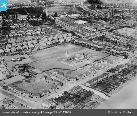
EPW043967 ENGLAND (1934). Hounslow Heath Junior School and the surrounding residential area, Hounslow West, 1934
© Copyright OpenStreetMap contributors and licensed by the OpenStreetMap Foundation. 2026. Cartography is licensed as CC BY-SA.
Nearby Images (6)
Details
| Title | [EPW043967] Hounslow Heath Junior School and the surrounding residential area, Hounslow West, 1934 |
| Reference | EPW043967 |
| Date | April-1934 |
| Link | |
| Place name | HOUNSLOW WEST |
| Parish | |
| District | |
| Country | ENGLAND |
| Easting / Northing | 512363, 175542 |
| Longitude / Latitude | -0.3821917930891, 51.467190019228 |
| National Grid Reference | TQ124755 |
Pins
Be the first to add a comment to this image!


![[EPW043967] Hounslow Heath Junior School and the surrounding residential area, Hounslow West, 1934](http://britainfromabove.org.uk/sites/all/libraries/aerofilms-images/public/100x100/EPW/043/EPW043967.jpg)
![[EPW043964] Hounslow Heath Junior School and the surrounding residential area, Hounslow West, 1934](http://britainfromabove.org.uk/sites/all/libraries/aerofilms-images/public/100x100/EPW/043/EPW043964.jpg)
![[EPW043969] Hounslow Heath Junior School and the surrounding residential area, Hounslow West, 1934](http://britainfromabove.org.uk/sites/all/libraries/aerofilms-images/public/100x100/EPW/043/EPW043969.jpg)
![[EPW043965] Hounslow Heath Junior School and the surrounding residential area, Hounslow West, 1934](http://britainfromabove.org.uk/sites/all/libraries/aerofilms-images/public/100x100/EPW/043/EPW043965.jpg)
![[EPW043966] Hounslow Heath Junior School and the surrounding residential area, Hounslow West, 1934](http://britainfromabove.org.uk/sites/all/libraries/aerofilms-images/public/100x100/EPW/043/EPW043966.jpg)
![[EPW043968] Hounslow Heath Junior School, Hounslow Barracks and environs, Hounslow West, 1934](http://britainfromabove.org.uk/sites/all/libraries/aerofilms-images/public/100x100/EPW/043/EPW043968.jpg)