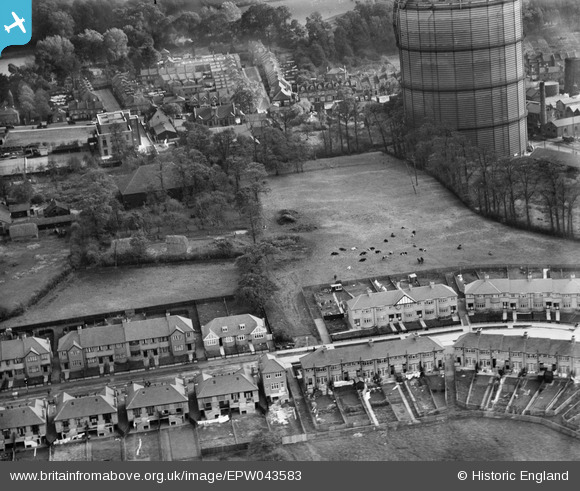
EPW043583 ENGLAND (1933). The Grange alongside Dudley Road and the Gas Works, Roxeth, 1933
© Copyright OpenStreetMap contributors and licensed by the OpenStreetMap Foundation. 2026. Cartography is licensed as CC BY-SA.
Nearby Images (7)
Details
| Title | [EPW043583] The Grange alongside Dudley Road and the Gas Works, Roxeth, 1933 |
| Reference | EPW043583 |
| Date | October-1933 |
| Link | |
| Place name | ROXETH |
| Parish | |
| District | |
| Country | ENGLAND |
| Easting / Northing | 514325, 186877 |
| Longitude / Latitude | -0.35027744222219, 51.568684531379 |
| National Grid Reference | TQ143869 |


![[EPW043583] The Grange alongside Dudley Road and the Gas Works, Roxeth, 1933](http://britainfromabove.org.uk/sites/all/libraries/aerofilms-images/public/100x100/EPW/043/EPW043583.jpg)
![[EPW043581] The Grange alongside the Gas Works, Roxeth, 1933](http://britainfromabove.org.uk/sites/all/libraries/aerofilms-images/public/100x100/EPW/043/EPW043581.jpg)
![[EPW043585] The Grange alongside the Gas Works, Roxeth, 1933](http://britainfromabove.org.uk/sites/all/libraries/aerofilms-images/public/100x100/EPW/043/EPW043585.jpg)
![[EPW043580] The Grange, Roxeth, 1933](http://britainfromabove.org.uk/sites/all/libraries/aerofilms-images/public/100x100/EPW/043/EPW043580.jpg)
![[EPW043582] The Grange alongside the Gas Works, Roxeth, 1933](http://britainfromabove.org.uk/sites/all/libraries/aerofilms-images/public/100x100/EPW/043/EPW043582.jpg)
![[EPW043584] The Grange and the Telephone Exchange alongside the Gas Works, Roxeth, 1933](http://britainfromabove.org.uk/sites/all/libraries/aerofilms-images/public/100x100/EPW/043/EPW043584.jpg)
![[EPW009579] The Gas Works on Northolt Road and environs, Roxeth, 1923. This image has been produced from a damaged negative.](http://britainfromabove.org.uk/sites/all/libraries/aerofilms-images/public/100x100/EPW/009/EPW009579.jpg)
