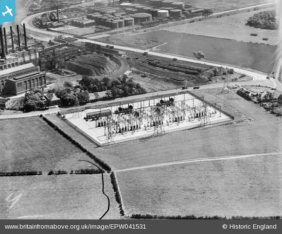
EPW041531 ENGLAND (1933). Dumplington electrical substation on Redclyffe Road, Dumplington, 1933
© Copyright OpenStreetMap contributors and licensed by the OpenStreetMap Foundation. 2026. Cartography is licensed as CC BY-SA.
Nearby Images (6)
Details
| Title | [EPW041531] Dumplington electrical substation on Redclyffe Road, Dumplington, 1933 |
| Reference | EPW041531 |
| Date | June-1933 |
| Link | |
| Place name | DUMPLINGTON |
| Parish | |
| District | |
| Country | ENGLAND |
| Easting / Northing | 376785, 397211 |
| Longitude / Latitude | -2.349773868113, 53.47086843095 |
| National Grid Reference | SJ768972 |
Pins

stardelta |
Wednesday 11th of June 2014 11:26:01 PM |


![[EPW041531] Dumplington electrical substation on Redclyffe Road, Dumplington, 1933](http://britainfromabove.org.uk/sites/all/libraries/aerofilms-images/public/100x100/EPW/041/EPW041531.jpg)
![[EPW041530] Dumplington electrical substation on Redclyffe Road, Dumplington, 1933](http://britainfromabove.org.uk/sites/all/libraries/aerofilms-images/public/100x100/EPW/041/EPW041530.jpg)
![[EPW041532] Dumplington electrical substation on Redclyffe Road, Dumplington, 1933](http://britainfromabove.org.uk/sites/all/libraries/aerofilms-images/public/100x100/EPW/041/EPW041532.jpg)
![[EAW000111] The Ford Motor Company shadow factory on Barton Dock Road, Trafford Park, from the north-west, 1946](http://britainfromabove.org.uk/sites/all/libraries/aerofilms-images/public/100x100/EAW/000/EAW000111.jpg)
![[EPW027776] Barton Power Station and environs, Dumplington, 1929. This image has been produced from a copy-negative.](http://britainfromabove.org.uk/sites/all/libraries/aerofilms-images/public/100x100/EPW/027/EPW027776.jpg)
![[EPW027510] Barton Power Station, Trafford Park, 1929](http://britainfromabove.org.uk/sites/all/libraries/aerofilms-images/public/100x100/EPW/027/EPW027510.jpg)