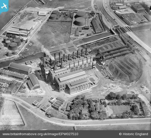
EPW027510 ENGLAND (1929). Barton Power Station, Trafford Park, 1929
    © Copyright OpenStreetMap contributors and licensed by the OpenStreetMap Foundation. 2025. Cartography is licensed as CC BY-SA.
  
Nearby Images (9)
Details
| Title | [EPW027510] Barton Power Station, Trafford Park, 1929 | 
| Reference | EPW027510 | 
| Date | 11-June-1929 | 
| Link | |
| Place name | TRAFFORD PARK | 
| Parish | |
| District | |
| Country | ENGLAND | 
| Easting / Northing | 376855, 397390 | 
| Longitude / Latitude | -2.3487324096913, 53.472480604563 | 
| National Grid Reference | SJ769974 | 
Pins
|  Interesting photo close up of this tow path. 
https://collection.sciencemuseumgroup.org.uk/documents/aa110016302/works-photographic-negative-of-cables-on-canal-causeway-stretford |   Stew R | Monday 24th of February 2020 01:01:29 PM | 
|  Manchester Ship Canal |   Dylan Moore | Wednesday 5th of June 2019 09:35:09 AM | 
|  Coal barges |   stardelta | Tuesday 15th of January 2013 09:47:17 PM | 
|  Ashburton Road (B5214) |   Fantasma | Wednesday 26th of December 2012 02:48:43 PM | 
|  Bridgewater Canal |   Fantasma | Wednesday 26th of December 2012 02:47:56 PM | 
|  Red Hall barton |   howard2 | Friday 14th of December 2012 07:44:17 PM | 
User Comment Contributions
| Hi I'm sorry guys but I think this is another power station. I lived next to Barton Power Station and everything, including the nearby bridges was different. Sorry :( I'll have a hunt and see if I can find some pictures. |   Lesley | Saturday 22nd of March 2014 09:25:35 PM | 
| It looks spot on to me. It's a view looking northeast, with the remains of the petroleum depot on the other side of the canal. |   Tony D | Saturday 22nd of March 2014 09:25:35 PM | 
 
             
  ![[EPW027510] Barton Power Station, Trafford Park, 1929](http://britainfromabove.org.uk/sites/all/libraries/aerofilms-images/public/100x100/EPW/027/EPW027510.jpg) 
  
                                          ![[EPW027776] Barton Power Station and environs, Dumplington, 1929. This image has been produced from a copy-negative.](http://britainfromabove.org.uk/sites/all/libraries/aerofilms-images/public/100x100/EPW/027/EPW027776.jpg) 
 ![[EAW006232] Barton Swing Aqueduct, Barton Power Station and environs, Trafford Park, 1947](http://britainfromabove.org.uk/sites/all/libraries/aerofilms-images/public/100x100/EAW/006/EAW006232.jpg) 
 ![[EPW041532] Dumplington electrical substation on Redclyffe Road, Dumplington, 1933](http://britainfromabove.org.uk/sites/all/libraries/aerofilms-images/public/100x100/EPW/041/EPW041532.jpg) 
 ![[EPW031020] The Texas Oil Co. and Manchester Ship Canal, Trafford Park, 1929](http://britainfromabove.org.uk/sites/all/libraries/aerofilms-images/public/100x100/EPW/031/EPW031020.jpg) 
 ![[EPW041531] Dumplington electrical substation on Redclyffe Road, Dumplington, 1933](http://britainfromabove.org.uk/sites/all/libraries/aerofilms-images/public/100x100/EPW/041/EPW041531.jpg) 
 ![[EAW006233] Barton Swing Aqueduct, Barton Power Station and environs, Dumplington, 1947](http://britainfromabove.org.uk/sites/all/libraries/aerofilms-images/public/100x100/EAW/006/EAW006233.jpg) 
 ![[EPW041530] Dumplington electrical substation on Redclyffe Road, Dumplington, 1933](http://britainfromabove.org.uk/sites/all/libraries/aerofilms-images/public/100x100/EPW/041/EPW041530.jpg) 
 ![[EAW006234] Barton Swing Aqueduct, Barton Upon Irwell, 1947](http://britainfromabove.org.uk/sites/all/libraries/aerofilms-images/public/100x100/EAW/006/EAW006234.jpg)