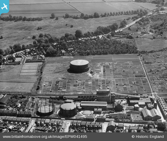
EPW041495 ENGLAND (1933). The Bracebridge Gasworks, Lincoln, 1933
© Copyright OpenStreetMap contributors and licensed by the OpenStreetMap Foundation. 2026. Cartography is licensed as CC BY-SA.
Nearby Images (24)
Details
| Title | [EPW041495] The Bracebridge Gasworks, Lincoln, 1933 |
| Reference | EPW041495 |
| Date | June-1933 |
| Link | |
| Place name | LINCOLN |
| Parish | |
| District | |
| Country | ENGLAND |
| Easting / Northing | 497188, 368740 |
| Longitude / Latitude | -0.54468034695165, 53.206547970541 |
| National Grid Reference | SK972687 |
Pins

Thomas Clark |
Tuesday 19th of March 2024 02:13:02 PM | |

John Herridge |
Tuesday 27th of April 2021 12:05:16 PM | |

John Wass |
Sunday 5th of April 2015 12:02:21 PM |


![[EPW041495] The Bracebridge Gasworks, Lincoln, 1933](http://britainfromabove.org.uk/sites/all/libraries/aerofilms-images/public/100x100/EPW/041/EPW041495.jpg)
![[EAW002779] The Gas Works and South Common, Bracebridge, 1946](http://britainfromabove.org.uk/sites/all/libraries/aerofilms-images/public/100x100/EAW/002/EAW002779.jpg)
![[EAW002778] The Gas Works, Bracebridge, 1946](http://britainfromabove.org.uk/sites/all/libraries/aerofilms-images/public/100x100/EAW/002/EAW002778.jpg)
![[EAW003302] The Lincoln Gas Works and environs, Bracebridge, 1946](http://britainfromabove.org.uk/sites/all/libraries/aerofilms-images/public/100x100/EAW/003/EAW003302.jpg)
![[EAW003303] The Lincoln Gas Works and environs, Bracebridge, 1946](http://britainfromabove.org.uk/sites/all/libraries/aerofilms-images/public/100x100/EAW/003/EAW003303.jpg)
![[EAW003304] Newark Road, the Lincoln Gas Works and environs, Bracebridge, 1946](http://britainfromabove.org.uk/sites/all/libraries/aerofilms-images/public/100x100/EAW/003/EAW003304.jpg)
![[EAW003305] The Lincoln Gas Works and environs, Bracebridge, 1946](http://britainfromabove.org.uk/sites/all/libraries/aerofilms-images/public/100x100/EAW/003/EAW003305.jpg)
![[EAW003301] The Lincoln Gas Works and environs, Bracebridge, 1946](http://britainfromabove.org.uk/sites/all/libraries/aerofilms-images/public/100x100/EAW/003/EAW003301.jpg)
![[EPW041496] The Bracebridge Gasworks, Lincoln, 1933](http://britainfromabove.org.uk/sites/all/libraries/aerofilms-images/public/100x100/EPW/041/EPW041496.jpg)
![[EAW002780] The Gas Works, Bracebridge, 1946](http://britainfromabove.org.uk/sites/all/libraries/aerofilms-images/public/100x100/EAW/002/EAW002780.jpg)
![[EAW002776] The Gas Works and environs, Bracebridge, 1946](http://britainfromabove.org.uk/sites/all/libraries/aerofilms-images/public/100x100/EAW/002/EAW002776.jpg)
![[EAW002777] The Gas Works and environs, Bracebridge, 1946](http://britainfromabove.org.uk/sites/all/libraries/aerofilms-images/public/100x100/EAW/002/EAW002777.jpg)
![[EAW002775] Newark Road, the Gas Works and environs, Bracebridge, 1946](http://britainfromabove.org.uk/sites/all/libraries/aerofilms-images/public/100x100/EAW/002/EAW002775.jpg)
![[EPW041498] The Bracebridge Gasworks, Lincoln, 1933](http://britainfromabove.org.uk/sites/all/libraries/aerofilms-images/public/100x100/EPW/041/EPW041498.jpg)
![[EPW041499] The Bracebridge Gasworks, Lincoln, 1933](http://britainfromabove.org.uk/sites/all/libraries/aerofilms-images/public/100x100/EPW/041/EPW041499.jpg)
![[EPW041500] The Bracebridge Gasworks, Lincoln, 1933](http://britainfromabove.org.uk/sites/all/libraries/aerofilms-images/public/100x100/EPW/041/EPW041500.jpg)
![[EPW041497] The Bracebridge Gasworks looking towards Lincoln Cathedral, Lincoln, from the south, 1933](http://britainfromabove.org.uk/sites/all/libraries/aerofilms-images/public/100x100/EPW/041/EPW041497.jpg)
![[EAW003306] The Lincoln Gas Works and environs, Bracebridge, 1946](http://britainfromabove.org.uk/sites/all/libraries/aerofilms-images/public/100x100/EAW/003/EAW003306.jpg)
![[EAW003308] The Lincoln Gas Works and environs, Bracebridge, 1946](http://britainfromabove.org.uk/sites/all/libraries/aerofilms-images/public/100x100/EAW/003/EAW003308.jpg)
![[EAW003309] The Lincoln Gas Works and environs, Bracebridge, 1946](http://britainfromabove.org.uk/sites/all/libraries/aerofilms-images/public/100x100/EAW/003/EAW003309.jpg)
![[EAW003310] The Lincoln Gas Works and environs, Bracebridge, 1946](http://britainfromabove.org.uk/sites/all/libraries/aerofilms-images/public/100x100/EAW/003/EAW003310.jpg)
![[EAW003307] The Lincoln Gas Works and environs, Bracebridge, 1946](http://britainfromabove.org.uk/sites/all/libraries/aerofilms-images/public/100x100/EAW/003/EAW003307.jpg)
![[EPW041501] The Bracebridge Gasworks looking towards Lincoln Cathedral, Lincoln, from the south, 1933](http://britainfromabove.org.uk/sites/all/libraries/aerofilms-images/public/100x100/EPW/041/EPW041501.jpg)
![[EAW003311] The Lincoln Gas Works and environs, Bracebridge, from the south-east, 1946](http://britainfromabove.org.uk/sites/all/libraries/aerofilms-images/public/100x100/EAW/003/EAW003311.jpg)