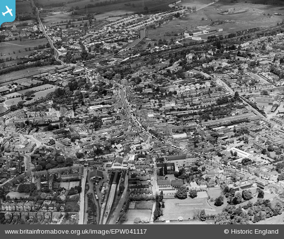
EPW041117 ENGLAND (1933). The High Street and environs, Uxbridge, 1933
© Copyright OpenStreetMap contributors and licensed by the OpenStreetMap Foundation. 2026. Cartography is licensed as CC BY-SA.
Nearby Images (17)
Details
| Title | [EPW041117] The High Street and environs, Uxbridge, 1933 |
| Reference | EPW041117 |
| Date | May-1933 |
| Link | |
| Place name | UXBRIDGE |
| Parish | |
| District | |
| Country | ENGLAND |
| Easting / Northing | 505522, 184201 |
| Longitude / Latitude | -0.47805871810769, 51.54634588395 |
| National Grid Reference | TQ055842 |
Pins

Dom |
Wednesday 1st of April 2020 12:43:58 PM | |

Dom |
Wednesday 1st of April 2020 12:42:33 PM | |

The Laird |
Sunday 31st of May 2015 01:37:03 PM | |

John Wass |
Tuesday 30th of December 2014 03:09:07 PM | |

The Laird |
Tuesday 2nd of December 2014 11:59:28 PM | |

moses72 |
Friday 20th of December 2013 05:48:26 PM | |

moses72 |
Friday 20th of December 2013 05:42:52 PM | |

moses72 |
Friday 20th of December 2013 05:41:32 PM | |

Isleworth1961 |
Saturday 9th of November 2013 12:53:52 AM | |

maryjane65 |
Friday 30th of August 2013 05:52:47 PM | |

maryjane65 |
Friday 30th of August 2013 05:52:03 PM | |

maryjane65 |
Friday 30th of August 2013 05:45:42 PM | |

maryjane65 |
Friday 30th of August 2013 05:44:30 PM | |

maryjane65 |
Friday 30th of August 2013 05:43:54 PM | |

Isleworth1961 |
Sunday 9th of June 2013 11:59:50 PM | |

Isleworth1961 |
Sunday 9th of June 2013 11:58:47 PM | |
I think you will find that this is part of the Grand Union Canal and not railway. |

maryjane65 |
Friday 30th of August 2013 05:49:41 PM |
Oops! Yes, I didn't zoom in enough, now re-pinned! |

Isleworth1961 |
Saturday 9th of November 2013 12:55:23 AM |

Isleworth1961 |
Sunday 9th of June 2013 11:57:59 PM | |
This was known as Vine Street Station |

maryjane65 |
Friday 30th of August 2013 05:42:20 PM |
Yes, but it was just simply 'Uxbridge' until 1957, when 'Vine Street' was added. |

Isleworth1961 |
Saturday 9th of November 2013 01:01:09 AM |
User Comment Contributions
I worked at Sanderson Fabrics 1965-71 in the General Merchandise and Stock Control offices. |
.JPG)
Colin1949 |
Wednesday 5th of March 2014 04:39:27 PM |


![[EPW041117] The High Street and environs, Uxbridge, 1933](http://britainfromabove.org.uk/sites/all/libraries/aerofilms-images/public/100x100/EPW/041/EPW041117.jpg)
![[EPW031256] The High Street and environs, Uxbridge, 1930](http://britainfromabove.org.uk/sites/all/libraries/aerofilms-images/public/100x100/EPW/031/EPW031256.jpg)
![[EPW041116] The High Street and environs, Uxbridge, 1933](http://britainfromabove.org.uk/sites/all/libraries/aerofilms-images/public/100x100/EPW/041/EPW041116.jpg)
![[EPW031258] The High Street and environs, Uxbridge, 1930](http://britainfromabove.org.uk/sites/all/libraries/aerofilms-images/public/100x100/EPW/031/EPW031258.jpg)
![[EPW031257] St Margaret's Church and the town centre, Uxbridge, 1930](http://britainfromabove.org.uk/sites/all/libraries/aerofilms-images/public/100x100/EPW/031/EPW031257.jpg)
![[EPW041118] Vine Street Station and the town, Uxbridge, 1933](http://britainfromabove.org.uk/sites/all/libraries/aerofilms-images/public/100x100/EPW/041/EPW041118.jpg)
![[EPW022776] High Street, Uxbridge, 1928. This image has been produced from a print.](http://britainfromabove.org.uk/sites/all/libraries/aerofilms-images/public/100x100/EPW/022/EPW022776.jpg)
![[EPW022771] The junction of Harefield Road and the High Street, Uxbridge, 1928. This image has been produced from a print.](http://britainfromabove.org.uk/sites/all/libraries/aerofilms-images/public/100x100/EPW/022/EPW022771.jpg)
![[EPW025808] The Metropolitan Depot, Uxbridge, 1929](http://britainfromabove.org.uk/sites/all/libraries/aerofilms-images/public/100x100/EPW/025/EPW025808.jpg)
![[EPW025814] The Metropolitan Depot, Uxbridge, 1929](http://britainfromabove.org.uk/sites/all/libraries/aerofilms-images/public/100x100/EPW/025/EPW025814.jpg)
![[EPW025813] The Metropolitan Depot, Uxbridge, 1929](http://britainfromabove.org.uk/sites/all/libraries/aerofilms-images/public/100x100/EPW/025/EPW025813.jpg)
![[EPW025815] The Metropolitan Depot, Uxbridge, 1929](http://britainfromabove.org.uk/sites/all/libraries/aerofilms-images/public/100x100/EPW/025/EPW025815.jpg)
![[EPW025812] The Metropolitan Depot, Uxbridge, 1929](http://britainfromabove.org.uk/sites/all/libraries/aerofilms-images/public/100x100/EPW/025/EPW025812.jpg)
![[EPW025807] The Metropolitan Depot, Uxbridge, 1929](http://britainfromabove.org.uk/sites/all/libraries/aerofilms-images/public/100x100/EPW/025/EPW025807.jpg)
![[EPW025810] The Metropolitan Depot, Uxbridge, 1929](http://britainfromabove.org.uk/sites/all/libraries/aerofilms-images/public/100x100/EPW/025/EPW025810.jpg)
![[EPW025806] The Metropolitan Depot, Uxbridge, 1929](http://britainfromabove.org.uk/sites/all/libraries/aerofilms-images/public/100x100/EPW/025/EPW025806.jpg)
![[EPW025811] The Metropolitan Depot, Uxbridge, 1929](http://britainfromabove.org.uk/sites/all/libraries/aerofilms-images/public/100x100/EPW/025/EPW025811.jpg)