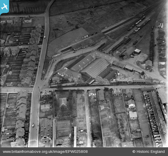
EPW025808 ENGLAND (1929). The Metropolitan Depot, Uxbridge, 1929
© Copyright OpenStreetMap contributors and licensed by the OpenStreetMap Foundation. 2026. Cartography is licensed as CC BY-SA.
Nearby Images (15)
Details
| Title | [EPW025808] The Metropolitan Depot, Uxbridge, 1929 |
| Reference | EPW025808 |
| Date | 1929 |
| Link | |
| Place name | UXBRIDGE |
| Parish | |
| District | |
| Country | ENGLAND |
| Easting / Northing | 505729, 184339 |
| Longitude / Latitude | -0.47503281913967, 51.547547645631 |
| National Grid Reference | TQ057843 |
Pins

The Laird |
Sunday 6th of March 2016 06:29:22 PM | |

brian |
Friday 24th of January 2014 01:53:47 PM | |

brian |
Friday 24th of January 2014 01:48:06 PM | |

brian |
Friday 24th of January 2014 01:46:24 PM |


![[EPW025808] The Metropolitan Depot, Uxbridge, 1929](http://britainfromabove.org.uk/sites/all/libraries/aerofilms-images/public/100x100/EPW/025/EPW025808.jpg)
![[EPW025813] The Metropolitan Depot, Uxbridge, 1929](http://britainfromabove.org.uk/sites/all/libraries/aerofilms-images/public/100x100/EPW/025/EPW025813.jpg)
![[EPW025812] The Metropolitan Depot, Uxbridge, 1929](http://britainfromabove.org.uk/sites/all/libraries/aerofilms-images/public/100x100/EPW/025/EPW025812.jpg)
![[EPW025814] The Metropolitan Depot, Uxbridge, 1929](http://britainfromabove.org.uk/sites/all/libraries/aerofilms-images/public/100x100/EPW/025/EPW025814.jpg)
![[EPW025815] The Metropolitan Depot, Uxbridge, 1929](http://britainfromabove.org.uk/sites/all/libraries/aerofilms-images/public/100x100/EPW/025/EPW025815.jpg)
![[EPW025810] The Metropolitan Depot, Uxbridge, 1929](http://britainfromabove.org.uk/sites/all/libraries/aerofilms-images/public/100x100/EPW/025/EPW025810.jpg)
![[EPW025806] The Metropolitan Depot, Uxbridge, 1929](http://britainfromabove.org.uk/sites/all/libraries/aerofilms-images/public/100x100/EPW/025/EPW025806.jpg)
![[EPW025807] The Metropolitan Depot, Uxbridge, 1929](http://britainfromabove.org.uk/sites/all/libraries/aerofilms-images/public/100x100/EPW/025/EPW025807.jpg)
![[EPW025811] The Metropolitan Depot, Uxbridge, 1929](http://britainfromabove.org.uk/sites/all/libraries/aerofilms-images/public/100x100/EPW/025/EPW025811.jpg)
![[EPW025809] The Metropolitan Depot, Uxbridge, 1929](http://britainfromabove.org.uk/sites/all/libraries/aerofilms-images/public/100x100/EPW/025/EPW025809.jpg)
![[EPW041117] The High Street and environs, Uxbridge, 1933](http://britainfromabove.org.uk/sites/all/libraries/aerofilms-images/public/100x100/EPW/041/EPW041117.jpg)
![[EPW031256] The High Street and environs, Uxbridge, 1930](http://britainfromabove.org.uk/sites/all/libraries/aerofilms-images/public/100x100/EPW/031/EPW031256.jpg)
![[EPW047466] The town, Uxbridge, from the east, 1935](http://britainfromabove.org.uk/sites/all/libraries/aerofilms-images/public/100x100/EPW/047/EPW047466.jpg)
![[EPW044514] The London Passenger Transport Board Metropolitan Line and the town, Uxbridge, 1934](http://britainfromabove.org.uk/sites/all/libraries/aerofilms-images/public/100x100/EPW/044/EPW044514.jpg)
![[EPW041116] The High Street and environs, Uxbridge, 1933](http://britainfromabove.org.uk/sites/all/libraries/aerofilms-images/public/100x100/EPW/041/EPW041116.jpg)