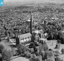
EPW041084 ENGLAND (1933). Salisbury Cathedral and environs, Salisbury, 1933
© Copyright OpenStreetMap contributors and licensed by the OpenStreetMap Foundation. 2026. Cartography is licensed as CC BY-SA.
Nearby Images (26)
Details
| Title | [EPW041084] Salisbury Cathedral and environs, Salisbury, 1933 |
| Reference | EPW041084 |
| Date | May-1933 |
| Link | |
| Place name | SALISBURY |
| Parish | SALISBURY |
| District | |
| Country | ENGLAND |
| Easting / Northing | 414301, 129518 |
| Longitude / Latitude | -1.7958919766842, 51.064284866411 |
| National Grid Reference | SU143295 |
Pins

Class31 |
Wednesday 15th of January 2014 05:20:38 PM | |

Class31 |
Wednesday 15th of January 2014 05:07:15 PM | |

Class31 |
Monday 21st of October 2013 09:38:47 PM | |

Class31 |
Monday 21st of October 2013 09:37:05 PM | |

Class31 |
Monday 21st of October 2013 09:35:16 PM | |

Class31 |
Monday 21st of October 2013 09:33:29 PM |
User Comment Contributions
Salisbury Cathedral, the interior of the nave looking west, 08/03/2007 |

Class31 |
Friday 5th of February 2016 11:53:07 AM |
Cathedral Church of the Blessed Virgin Mary 02/04/2014 |

Class31 |
Wednesday 2nd of April 2014 07:44:26 PM |
Cathedral Church of the Blessed Virgin Mary 02/04/2014 |

Class31 |
Wednesday 2nd of April 2014 07:42:05 PM |
The Parish Church of St. Thomas and St. Edmunds 15/01/2014 |

Class31 |
Wednesday 15th of January 2014 05:12:14 PM |
Salisbury Cathedral is a splendid example of pure Early English Gothic architecture and was built within a relatively short period of forty years (1220-1260). In this clear image taken exactly eighty years ago, on a fine spring morning, looking in a north-easterly direction, the various parts of the building lead the eye to the central point, the richly-adorned spire (1250), which is the loftiest in England (406 feet). The tallest church spire in the kingdom is surely worthy of inclusion. |

John Swain |
Friday 17th of May 2013 08:40:42 AM |


![[EPW041084] Salisbury Cathedral and environs, Salisbury, 1933](http://britainfromabove.org.uk/sites/all/libraries/aerofilms-images/public/100x100/EPW/041/EPW041084.jpg)
![[EPW041083] Salisbury Cathedral, Salisbury, 1933](http://britainfromabove.org.uk/sites/all/libraries/aerofilms-images/public/100x100/EPW/041/EPW041083.jpg)
![[EAW051967] St Mary's Cathedral and the city, Salisbury, from the south, 1953](http://britainfromabove.org.uk/sites/all/libraries/aerofilms-images/public/100x100/EAW/051/EAW051967.jpg)
![[EAW025826] St Mary's Cathedral, Salisbury, 1949](http://britainfromabove.org.uk/sites/all/libraries/aerofilms-images/public/100x100/EAW/025/EAW025826.jpg)
![[EAW051969] St Mary's Cathedral, Salisbury, 1953](http://britainfromabove.org.uk/sites/all/libraries/aerofilms-images/public/100x100/EAW/051/EAW051969.jpg)
![[EAW025829] St Mary's Cathedral (site of), Salisbury, 1949. This image has been produced from a damaged negative.](http://britainfromabove.org.uk/sites/all/libraries/aerofilms-images/public/100x100/EAW/025/EAW025829.jpg)
![[EAW025832] St Mary's Cathedral, Salisbury, 1949. This image has been produced from a print.](http://britainfromabove.org.uk/sites/all/libraries/aerofilms-images/public/100x100/EAW/025/EAW025832.jpg)
![[EAW051986] St Mary's Cathedral, Salisbury, 1953](http://britainfromabove.org.uk/sites/all/libraries/aerofilms-images/public/100x100/EAW/051/EAW051986.jpg)
![[EAW003563] Salisbury Cathedral, Salisbury, from the north-west, 1947](http://britainfromabove.org.uk/sites/all/libraries/aerofilms-images/public/100x100/EAW/003/EAW003563.jpg)
![[EAW003562] Salisbury Cathedral, Salisbury, 1947](http://britainfromabove.org.uk/sites/all/libraries/aerofilms-images/public/100x100/EAW/003/EAW003562.jpg)
![[EPW041080] Salisbury Cathedral and environs, Salisbury, from the east, 1933](http://britainfromabove.org.uk/sites/all/libraries/aerofilms-images/public/100x100/EPW/041/EPW041080.jpg)
![[EAW051974] St Mary's Cathedral and environs, Salisbury, from the south-east, 1953](http://britainfromabove.org.uk/sites/all/libraries/aerofilms-images/public/100x100/EAW/051/EAW051974.jpg)
![[EAW025828] St Mary's Cathedral (site of), Salisbury, 1949. This image has been produced from a damaged negative.](http://britainfromabove.org.uk/sites/all/libraries/aerofilms-images/public/100x100/EAW/025/EAW025828.jpg)
![[EAW051988] St Mary's Cathedral, Salisbury, 1953](http://britainfromabove.org.uk/sites/all/libraries/aerofilms-images/public/100x100/EAW/051/EAW051988.jpg)
![[EPW011038] St Mary's Cathedral and environs, Salisbury, 1924. This image has been produced from a copy-negative.](http://britainfromabove.org.uk/sites/all/libraries/aerofilms-images/public/100x100/EPW/011/EPW011038.jpg)
![[EPW011037] St Mary's Cathedral, Salisbury, 1924. This image has been produced from a copy-negative.](http://britainfromabove.org.uk/sites/all/libraries/aerofilms-images/public/100x100/EPW/011/EPW011037.jpg)
![[EAW003564] Salisbury Cathedral and the Bishop's Palace, Salisbury, 1947](http://britainfromabove.org.uk/sites/all/libraries/aerofilms-images/public/100x100/EAW/003/EAW003564.jpg)
![[EAW051976] St Mary's Cathedral and the city, Salisbury, from the south, 1953](http://britainfromabove.org.uk/sites/all/libraries/aerofilms-images/public/100x100/EAW/051/EAW051976.jpg)
![[EAW025827] St Mary's Cathedral, Salisbury, 1949](http://britainfromabove.org.uk/sites/all/libraries/aerofilms-images/public/100x100/EAW/025/EAW025827.jpg)
![[EAW025831] St Mary's Cathedral, Salisbury, 1949. This image has been produced from a print.](http://britainfromabove.org.uk/sites/all/libraries/aerofilms-images/public/100x100/EAW/025/EAW025831.jpg)
![[EAW051975] St Mary's Cathedral and the city, Salisbury, from the south, 1953](http://britainfromabove.org.uk/sites/all/libraries/aerofilms-images/public/100x100/EAW/051/EAW051975.jpg)
![[EAW051987] St Mary's Cathedral and environs, Salisbury, 1953](http://britainfromabove.org.uk/sites/all/libraries/aerofilms-images/public/100x100/EAW/051/EAW051987.jpg)
![[EAW051978] St Mary's Cathedral and the city, Salisbury, from the west, 1953](http://britainfromabove.org.uk/sites/all/libraries/aerofilms-images/public/100x100/EAW/051/EAW051978.jpg)
![[EAW051922] Exeter Street, Friary Lane and environs, Salisbury, 1953. This image was marked by Aerofilms Ltd for photo editing.](http://britainfromabove.org.uk/sites/all/libraries/aerofilms-images/public/100x100/EAW/051/EAW051922.jpg)
![[EAW051917] New Street and the city centre, Salisbury, 1953. This image was marked by Aerofilms Ltd for photo editing.](http://britainfromabove.org.uk/sites/all/libraries/aerofilms-images/public/100x100/EAW/051/EAW051917.jpg)
![[EAW025830] St Mary's Cathedral and the city, Salisbury, 1949. This image has been produced from a print.](http://britainfromabove.org.uk/sites/all/libraries/aerofilms-images/public/100x100/EAW/025/EAW025830.jpg)
