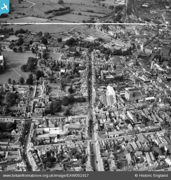
EAW051917 ENGLAND (1953). New Street and the city centre, Salisbury, 1953. This image was marked by Aerofilms Ltd for photo editing.
© Copyright OpenStreetMap contributors and licensed by the OpenStreetMap Foundation. 2026. Cartography is licensed as CC BY-SA.
Nearby Images (21)
Details
| Title | [EAW051917] New Street and the city centre, Salisbury, 1953. This image was marked by Aerofilms Ltd for photo editing. |
| Reference | EAW051917 |
| Date | 30-August-1953 |
| Link | |
| Place name | SALISBURY |
| Parish | SALISBURY |
| District | |
| Country | ENGLAND |
| Easting / Northing | 414430, 129766 |
| Longitude / Latitude | -1.7940409668621, 51.066511930456 |
| National Grid Reference | SU144298 |
Pins

Lydia |
Friday 13th of November 2020 04:54:59 PM |


![[EAW051917] New Street and the city centre, Salisbury, 1953. This image was marked by Aerofilms Ltd for photo editing.](http://britainfromabove.org.uk/sites/all/libraries/aerofilms-images/public/100x100/EAW/051/EAW051917.jpg)
![[EAW051921] New Street, New Canal and the city centre, Salisbury, 1953. This image was marked by Aerofilms Ltd for photo editing.](http://britainfromabove.org.uk/sites/all/libraries/aerofilms-images/public/100x100/EAW/051/EAW051921.jpg)
![[EAW025830] St Mary's Cathedral and the city, Salisbury, 1949. This image has been produced from a print.](http://britainfromabove.org.uk/sites/all/libraries/aerofilms-images/public/100x100/EAW/025/EAW025830.jpg)
![[EAW051973] New Canal and the city centre, Salisbury, 1953](http://britainfromabove.org.uk/sites/all/libraries/aerofilms-images/public/100x100/EAW/051/EAW051973.jpg)
![[EAW051968] St Mary's Cathedral, North Walk and environs, Salisbury, 1953](http://britainfromabove.org.uk/sites/all/libraries/aerofilms-images/public/100x100/EAW/051/EAW051968.jpg)
![[EAW051920] St Thomas's Church, New Canal and the city centre, Salisbury, 1953. This image was marked by Aerofilms Ltd for photo editing.](http://britainfromabove.org.uk/sites/all/libraries/aerofilms-images/public/100x100/EAW/051/EAW051920.jpg)
![[EPW011037] St Mary's Cathedral, Salisbury, 1924. This image has been produced from a copy-negative.](http://britainfromabove.org.uk/sites/all/libraries/aerofilms-images/public/100x100/EPW/011/EPW011037.jpg)
![[EPW011038] St Mary's Cathedral and environs, Salisbury, 1924. This image has been produced from a copy-negative.](http://britainfromabove.org.uk/sites/all/libraries/aerofilms-images/public/100x100/EPW/011/EPW011038.jpg)
![[EAW051922] Exeter Street, Friary Lane and environs, Salisbury, 1953. This image was marked by Aerofilms Ltd for photo editing.](http://britainfromabove.org.uk/sites/all/libraries/aerofilms-images/public/100x100/EAW/051/EAW051922.jpg)
![[EAW051988] St Mary's Cathedral, Salisbury, 1953](http://britainfromabove.org.uk/sites/all/libraries/aerofilms-images/public/100x100/EAW/051/EAW051988.jpg)
![[EAW051918] New Canal, the Market Place and the city centre, Salisbury, 1953](http://britainfromabove.org.uk/sites/all/libraries/aerofilms-images/public/100x100/EAW/051/EAW051918.jpg)
![[EAW003563] Salisbury Cathedral, Salisbury, from the north-west, 1947](http://britainfromabove.org.uk/sites/all/libraries/aerofilms-images/public/100x100/EAW/003/EAW003563.jpg)
![[EAW051970] The city centre, Salisbury, 1953](http://britainfromabove.org.uk/sites/all/libraries/aerofilms-images/public/100x100/EAW/051/EAW051970.jpg)
![[EAW051919] Brown Street, the Guildhall and the city centre, Salisbury, 1953. This image was marked by Aerofilms Ltd for photo editing.](http://britainfromabove.org.uk/sites/all/libraries/aerofilms-images/public/100x100/EAW/051/EAW051919.jpg)
![[EAW051986] St Mary's Cathedral, Salisbury, 1953](http://britainfromabove.org.uk/sites/all/libraries/aerofilms-images/public/100x100/EAW/051/EAW051986.jpg)
![[EAW025832] St Mary's Cathedral, Salisbury, 1949. This image has been produced from a print.](http://britainfromabove.org.uk/sites/all/libraries/aerofilms-images/public/100x100/EAW/025/EAW025832.jpg)
![[EPW041080] Salisbury Cathedral and environs, Salisbury, from the east, 1933](http://britainfromabove.org.uk/sites/all/libraries/aerofilms-images/public/100x100/EPW/041/EPW041080.jpg)
![[EAW025826] St Mary's Cathedral, Salisbury, 1949](http://britainfromabove.org.uk/sites/all/libraries/aerofilms-images/public/100x100/EAW/025/EAW025826.jpg)
![[EAW051969] St Mary's Cathedral, Salisbury, 1953](http://britainfromabove.org.uk/sites/all/libraries/aerofilms-images/public/100x100/EAW/051/EAW051969.jpg)
![[EAW051978] St Mary's Cathedral and the city, Salisbury, from the west, 1953](http://britainfromabove.org.uk/sites/all/libraries/aerofilms-images/public/100x100/EAW/051/EAW051978.jpg)
![[EPW041084] Salisbury Cathedral and environs, Salisbury, 1933](http://britainfromabove.org.uk/sites/all/libraries/aerofilms-images/public/100x100/EPW/041/EPW041084.jpg)