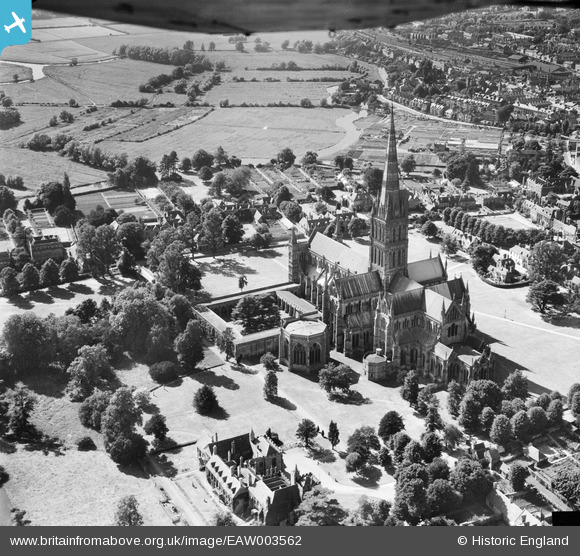
EAW003562 ENGLAND (1947). Salisbury Cathedral, Salisbury, 1947
© Copyright OpenStreetMap contributors and licensed by the OpenStreetMap Foundation. 2026. Cartography is licensed as CC BY-SA.
Nearby Images (24)
Details
| Title | [EAW003562] Salisbury Cathedral, Salisbury, 1947 |
| Reference | EAW003562 |
| Date | March-1947 |
| Link | |
| Place name | SALISBURY |
| Parish | SALISBURY |
| District | |
| Country | ENGLAND |
| Easting / Northing | 414233, 129513 |
| Longitude / Latitude | -1.7968626826771, 51.06424159133 |
| National Grid Reference | SU142295 |
Pins

Class31 |
Thursday 18th of September 2014 08:23:24 PM |
User Comment Contributions
The Cloisters, Salisbury Cathedral, Salisbury, 18/09/2014 |

Class31 |
Thursday 18th of September 2014 08:25:58 PM |
Cathedral Church of the Blessed Virgin Mary 02/04/2014 |

Class31 |
Wednesday 2nd of April 2014 08:08:45 PM |
Cathedral Church of the Blessed Virgin Mary 02/04/2014 |

Class31 |
Wednesday 2nd of April 2014 08:07:57 PM |


![[EAW003562] Salisbury Cathedral, Salisbury, 1947](http://britainfromabove.org.uk/sites/all/libraries/aerofilms-images/public/100x100/EAW/003/EAW003562.jpg)
![[EAW025829] St Mary's Cathedral (site of), Salisbury, 1949. This image has been produced from a damaged negative.](http://britainfromabove.org.uk/sites/all/libraries/aerofilms-images/public/100x100/EAW/025/EAW025829.jpg)
![[EAW051969] St Mary's Cathedral, Salisbury, 1953](http://britainfromabove.org.uk/sites/all/libraries/aerofilms-images/public/100x100/EAW/051/EAW051969.jpg)
![[EAW051976] St Mary's Cathedral and the city, Salisbury, from the south, 1953](http://britainfromabove.org.uk/sites/all/libraries/aerofilms-images/public/100x100/EAW/051/EAW051976.jpg)
![[EPW041084] Salisbury Cathedral and environs, Salisbury, 1933](http://britainfromabove.org.uk/sites/all/libraries/aerofilms-images/public/100x100/EPW/041/EPW041084.jpg)
![[EAW051967] St Mary's Cathedral and the city, Salisbury, from the south, 1953](http://britainfromabove.org.uk/sites/all/libraries/aerofilms-images/public/100x100/EAW/051/EAW051967.jpg)
![[EPW041083] Salisbury Cathedral, Salisbury, 1933](http://britainfromabove.org.uk/sites/all/libraries/aerofilms-images/public/100x100/EPW/041/EPW041083.jpg)
![[EAW051974] St Mary's Cathedral and environs, Salisbury, from the south-east, 1953](http://britainfromabove.org.uk/sites/all/libraries/aerofilms-images/public/100x100/EAW/051/EAW051974.jpg)
![[EAW051986] St Mary's Cathedral, Salisbury, 1953](http://britainfromabove.org.uk/sites/all/libraries/aerofilms-images/public/100x100/EAW/051/EAW051986.jpg)
![[EAW025826] St Mary's Cathedral, Salisbury, 1949](http://britainfromabove.org.uk/sites/all/libraries/aerofilms-images/public/100x100/EAW/025/EAW025826.jpg)
![[EAW051975] St Mary's Cathedral and the city, Salisbury, from the south, 1953](http://britainfromabove.org.uk/sites/all/libraries/aerofilms-images/public/100x100/EAW/051/EAW051975.jpg)
![[EAW025832] St Mary's Cathedral, Salisbury, 1949. This image has been produced from a print.](http://britainfromabove.org.uk/sites/all/libraries/aerofilms-images/public/100x100/EAW/025/EAW025832.jpg)
![[EAW051987] St Mary's Cathedral and environs, Salisbury, 1953](http://britainfromabove.org.uk/sites/all/libraries/aerofilms-images/public/100x100/EAW/051/EAW051987.jpg)
![[EAW051988] St Mary's Cathedral, Salisbury, 1953](http://britainfromabove.org.uk/sites/all/libraries/aerofilms-images/public/100x100/EAW/051/EAW051988.jpg)
![[EAW003563] Salisbury Cathedral, Salisbury, from the north-west, 1947](http://britainfromabove.org.uk/sites/all/libraries/aerofilms-images/public/100x100/EAW/003/EAW003563.jpg)
![[EPW011038] St Mary's Cathedral and environs, Salisbury, 1924. This image has been produced from a copy-negative.](http://britainfromabove.org.uk/sites/all/libraries/aerofilms-images/public/100x100/EPW/011/EPW011038.jpg)
![[EAW003564] Salisbury Cathedral and the Bishop's Palace, Salisbury, 1947](http://britainfromabove.org.uk/sites/all/libraries/aerofilms-images/public/100x100/EAW/003/EAW003564.jpg)
![[EAW025828] St Mary's Cathedral (site of), Salisbury, 1949. This image has been produced from a damaged negative.](http://britainfromabove.org.uk/sites/all/libraries/aerofilms-images/public/100x100/EAW/025/EAW025828.jpg)
![[EAW051978] St Mary's Cathedral and the city, Salisbury, from the west, 1953](http://britainfromabove.org.uk/sites/all/libraries/aerofilms-images/public/100x100/EAW/051/EAW051978.jpg)
![[EPW041080] Salisbury Cathedral and environs, Salisbury, from the east, 1933](http://britainfromabove.org.uk/sites/all/libraries/aerofilms-images/public/100x100/EPW/041/EPW041080.jpg)
![[EAW025831] St Mary's Cathedral, Salisbury, 1949. This image has been produced from a print.](http://britainfromabove.org.uk/sites/all/libraries/aerofilms-images/public/100x100/EAW/025/EAW025831.jpg)
![[EPW011037] St Mary's Cathedral, Salisbury, 1924. This image has been produced from a copy-negative.](http://britainfromabove.org.uk/sites/all/libraries/aerofilms-images/public/100x100/EPW/011/EPW011037.jpg)
![[EAW025827] St Mary's Cathedral, Salisbury, 1949](http://britainfromabove.org.uk/sites/all/libraries/aerofilms-images/public/100x100/EAW/025/EAW025827.jpg)
![[EAW051977] St Mary's Cathedral and the city, Salisbury, from the west, 1953](http://britainfromabove.org.uk/sites/all/libraries/aerofilms-images/public/100x100/EAW/051/EAW051977.jpg)