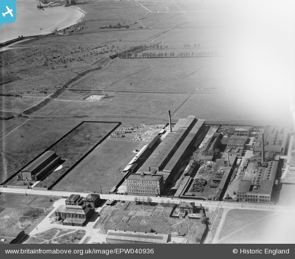
EPW040936 ENGLAND (1933). The Union Cable Co Works and environs, Dagenham, 1933. This image has been affected by flare.
© Copyright OpenStreetMap contributors and licensed by the OpenStreetMap Foundation. 2025. Cartography is licensed as CC BY-SA.
Nearby Images (27)
Details
| Title | [EPW040936] The Union Cable Co Works and environs, Dagenham, 1933. This image has been affected by flare. |
| Reference | EPW040936 |
| Date | April-1933 |
| Link | |
| Place name | DAGENHAM |
| Parish | |
| District | |
| Country | ENGLAND |
| Easting / Northing | 548751, 182656 |
| Longitude / Latitude | 0.14437757678936, 51.522722856528 |
| National Grid Reference | TQ488827 |
Pins
Be the first to add a comment to this image!


![[EPW040936] The Union Cable Co Works and environs, Dagenham, 1933. This image has been affected by flare.](http://britainfromabove.org.uk/sites/all/libraries/aerofilms-images/public/100x100/EPW/040/EPW040936.jpg)
![[EPW040934] The Union Cable Co Works, the Dagenham Marshes and environs, Dagenham, 1933](http://britainfromabove.org.uk/sites/all/libraries/aerofilms-images/public/100x100/EPW/040/EPW040934.jpg)
![[EPW040935] The Union Cable Co Works and Dagenham Stadium in the distance, Dagenham, 1933](http://britainfromabove.org.uk/sites/all/libraries/aerofilms-images/public/100x100/EPW/040/EPW040935.jpg)
![[EPW040937] The Union Cable Co Works and environs, Dagenham, 1933](http://britainfromabove.org.uk/sites/all/libraries/aerofilms-images/public/100x100/EPW/040/EPW040937.jpg)
![[EPW040933] The Union Cable Co Works, the Dagenham Marshes and environs, Dagenham, 1933](http://britainfromabove.org.uk/sites/all/libraries/aerofilms-images/public/100x100/EPW/040/EPW040933.jpg)
![[EPW037319] The Union Cable Company Ltd Works, Dagenham, 1932](http://britainfromabove.org.uk/sites/all/libraries/aerofilms-images/public/100x100/EPW/037/EPW037319.jpg)
![[EPW040939] The Union Cable Co Works, the Dagenham Marshes and environs, Dagenham, 1933](http://britainfromabove.org.uk/sites/all/libraries/aerofilms-images/public/100x100/EPW/040/EPW040939.jpg)
![[EPW040938] The Union Cable Co Works and Dagenham Stadium in the distance, Dagenham, 1933](http://britainfromabove.org.uk/sites/all/libraries/aerofilms-images/public/100x100/EPW/040/EPW040938.jpg)
![[EAW031158] The Pritchett and Gold and E.P.S. Co Ltd Storage Battery Works, Dagenham, 1950. This image was marked by Aerofilms Ltd for photo editing.](http://britainfromabove.org.uk/sites/all/libraries/aerofilms-images/public/100x100/EAW/031/EAW031158.jpg)
![[EPW037318] The Union Cable Company Ltd Works, Dagenham, 1932](http://britainfromabove.org.uk/sites/all/libraries/aerofilms-images/public/100x100/EPW/037/EPW037318.jpg)
![[EAW031757] Pritchett and Gold and E.P.S. Co Ltd Storage Battery Works at Dagenham Dock, Dagenham, 1950. This image was marked by Aerofilms Ltd for photo editing.](http://britainfromabove.org.uk/sites/all/libraries/aerofilms-images/public/100x100/EAW/031/EAW031757.jpg)
![[EAW031618] Pritchett and Gold and E.P.S. Co Ltd Storage Battery Works at Dagenham Dock, Dagenham, 1950](http://britainfromabove.org.uk/sites/all/libraries/aerofilms-images/public/100x100/EAW/031/EAW031618.jpg)
![[EAW031625] Pritchett and Gold and E.P.S. Co Ltd Storage Battery Works at Dagenham Dock, Dagenham, 1950](http://britainfromabove.org.uk/sites/all/libraries/aerofilms-images/public/100x100/EAW/031/EAW031625.jpg)
![[EAW031155] The Pritchett and Gold and E.P.S. Co Ltd Storage Battery Works, Dagenham, 1950. This image was marked by Aerofilms Ltd for photo editing.](http://britainfromabove.org.uk/sites/all/libraries/aerofilms-images/public/100x100/EAW/031/EAW031155.jpg)
![[EAW031622] Pritchett and Gold and E.P.S. Co Ltd Storage Battery Works at Dagenham Dock and environs, Dagenham, 1950](http://britainfromabove.org.uk/sites/all/libraries/aerofilms-images/public/100x100/EAW/031/EAW031622.jpg)
![[EAW031620] Pritchett and Gold and E.P.S. Co Ltd Storage Battery Works at Dagenham Dock, Dagenham, 1950](http://britainfromabove.org.uk/sites/all/libraries/aerofilms-images/public/100x100/EAW/031/EAW031620.jpg)
![[EAW031623] Pritchett and Gold and E.P.S. Co Ltd Storage Battery Works at Dagenham Dock, Dagenham, 1950](http://britainfromabove.org.uk/sites/all/libraries/aerofilms-images/public/100x100/EAW/031/EAW031623.jpg)
![[EAW031627] Pritchett and Gold and E.P.S. Co Ltd Storage Battery Works at Dagenham Dock and environs, Dagenham, 1950](http://britainfromabove.org.uk/sites/all/libraries/aerofilms-images/public/100x100/EAW/031/EAW031627.jpg)
![[EAW031763] Pritchett and Gold and E.P.S. Co Ltd Storage Battery Works at Dagenham Dock, Dagenham, 1950](http://britainfromabove.org.uk/sites/all/libraries/aerofilms-images/public/100x100/EAW/031/EAW031763.jpg)
![[EAW031621] Pritchett and Gold and E.P.S. Co Ltd Storage Battery Works at Dagenham Dock, Dagenham, 1950](http://britainfromabove.org.uk/sites/all/libraries/aerofilms-images/public/100x100/EAW/031/EAW031621.jpg)
![[EPW005330] The Union Cable Company, Dagenham, 1921](http://britainfromabove.org.uk/sites/all/libraries/aerofilms-images/public/100x100/EPW/005/EPW005330.jpg)
![[EAW031758] Pritchett and Gold and E.P.S. Co Ltd Storage Battery Works at Dagenham Dock, Dagenham, 1950. This image was marked by Aerofilms Ltd for photo editing.](http://britainfromabove.org.uk/sites/all/libraries/aerofilms-images/public/100x100/EAW/031/EAW031758.jpg)
![[EAW031764] Pritchett and Gold and E.P.S. Co Ltd Storage Battery Works at Dagenham Dock, Dagenham, 1950. This image was marked by Aerofilms Ltd for photo editing.](http://britainfromabove.org.uk/sites/all/libraries/aerofilms-images/public/100x100/EAW/031/EAW031764.jpg)
![[EAW031765] Pritchett and Gold and E.P.S. Co Ltd Storage Battery Works at Dagenham Dock, Dagenham, 1950. This image was marked by Aerofilms Ltd for photo editing.](http://britainfromabove.org.uk/sites/all/libraries/aerofilms-images/public/100x100/EAW/031/EAW031765.jpg)
![[EAW031762] Pritchett and Gold and E.P.S. Co Ltd Storage Battery Works at Dagenham Dock, Dagenham, 1950](http://britainfromabove.org.uk/sites/all/libraries/aerofilms-images/public/100x100/EAW/031/EAW031762.jpg)
![[EAW031756] Pritchett and Gold and E.P.S. Co Ltd Storage Battery Works at Dagenham Dock, Dagenham, 1950. This image was marked by Aerofilms Ltd for photo editing.](http://britainfromabove.org.uk/sites/all/libraries/aerofilms-images/public/100x100/EAW/031/EAW031756.jpg)
![[EAW031619] Pritchett and Gold and E.P.S. Co Ltd Storage Battery Works at Dagenham Dock, Dagenham, 1950](http://britainfromabove.org.uk/sites/all/libraries/aerofilms-images/public/100x100/EAW/031/EAW031619.jpg)