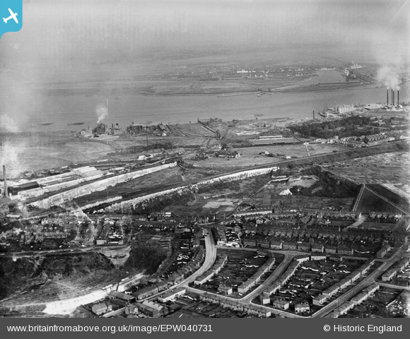
EPW040731 ENGLAND (1932). The High Street and the view to the River Thames, Swanscombe, from the south-west, 1932
© Copyright OpenStreetMap contributors and licensed by the OpenStreetMap Foundation. 2026. Cartography is licensed as CC BY-SA.
Nearby Images (5)
Details
| Title | [EPW040731] The High Street and the view to the River Thames, Swanscombe, from the south-west, 1932 |
| Reference | EPW040731 |
| Date | October-1932 |
| Link | |
| Place name | SWANSCOMBE |
| Parish | SWANSCOMBE AND GREENHITHE |
| District | |
| Country | ENGLAND |
| Easting / Northing | 560644, 174533 |
| Longitude / Latitude | 0.31198500179211, 51.446478350534 |
| National Grid Reference | TQ606745 |
Pins

Dylan Moore |
Saturday 4th of May 2013 02:51:26 AM |


![[EPW040731] The High Street and the view to the River Thames, Swanscombe, from the south-west, 1932](http://britainfromabove.org.uk/sites/all/libraries/aerofilms-images/public/100x100/EPW/040/EPW040731.jpg)
![[EPW040723] The High Street and factories beside Galley Hill Road, Swanscombe, from the south-west, 1932](http://britainfromabove.org.uk/sites/all/libraries/aerofilms-images/public/100x100/EPW/040/EPW040723.jpg)
![[EPW040719] The High Street and factories beside Galley Hill Road, Swanscombe, from the south-west, 1932](http://britainfromabove.org.uk/sites/all/libraries/aerofilms-images/public/100x100/EPW/040/EPW040719.jpg)
![[EPW040718] The High Street and Kent Kraft Paper Sack Mills, Swanscombe, 1932](http://britainfromabove.org.uk/sites/all/libraries/aerofilms-images/public/100x100/EPW/040/EPW040718.jpg)
![[EPW018632] The New Northfleet Paper Mills and environs, Swanscombe, 1927](http://britainfromabove.org.uk/sites/all/libraries/aerofilms-images/public/100x100/EPW/018/EPW018632.jpg)