
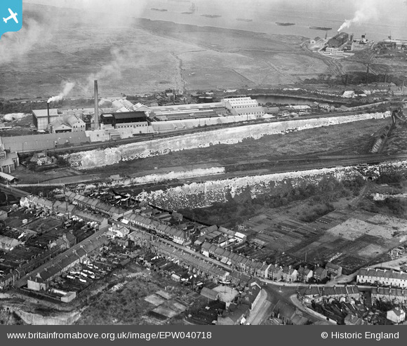
EPW040718 ENGLAND (1932). The High Street and Kent Kraft Paper Sack Mills, Swanscombe, 1932
© Copyright OpenStreetMap contributors and licensed by the OpenStreetMap Foundation. 2026. Cartography is licensed as CC BY-SA.
Nearby Images (23)
EPW040718

EPW018632

EPW040950

EPW040722

EPW040719

EAW050802

EAW050798

EAW050793

EAW050799

EAW050801

EPW028501

EPW028502

EPW040947

EAW050800

EPW040948

EPW040720

EPW018630

EPW040731

EPW040951

EAW050797

EPW040724

EPW040723

EPW018631

Details
| Title | [EPW040718] The High Street and Kent Kraft Paper Sack Mills, Swanscombe, 1932 |
| Reference | EPW040718 |
| Date | October-1932 |
| Link | |
| Place name | SWANSCOMBE |
| Parish | SWANSCOMBE AND GREENHITHE |
| District | |
| Country | ENGLAND |
| Easting / Northing | 560714, 174765 |
| Longitude / Latitude | 0.3130969392777, 51.448543066399 |
| National Grid Reference | TQ607748 |
Pins

andy |
Saturday 20th of July 2019 10:48:21 AM |