
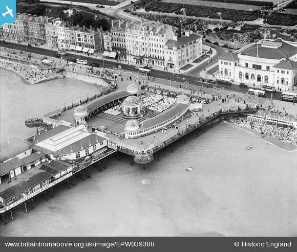
EPW039388 ENGLAND (1932). The Hastings Pier Band Stand, Hastings, 1932
© Copyright OpenStreetMap contributors and licensed by the OpenStreetMap Foundation. 2026. Cartography is licensed as CC BY-SA.
Nearby Images (25)
EPW039388

EPW035334

EAW022975

EPW026209

EPW026200

EPW035339

EPW000060B

EPW026191

EPW044648

EPW039390

EPW035342

EPW026188

EAW002409

EAW002408

EPW035346

EPW000754

EPW042840

EPW042839

EPW035345

EAW006618

EAW030089

EAW002407

EAW002410

EAW006619

EPW000115

Details
| Title | [EPW039388] The Hastings Pier Band Stand, Hastings, 1932 |
| Reference | EPW039388 |
| Date | August-1932 |
| Link | |
| Place name | HASTINGS |
| Parish | |
| District | |
| Country | ENGLAND |
| Easting / Northing | 581160, 109085 |
| Longitude / Latitude | 0.5740049987721, 50.85231210333 |
| National Grid Reference | TQ812091 |
Pins

SteveAUS |
Wednesday 27th of February 2013 04:26:11 AM |