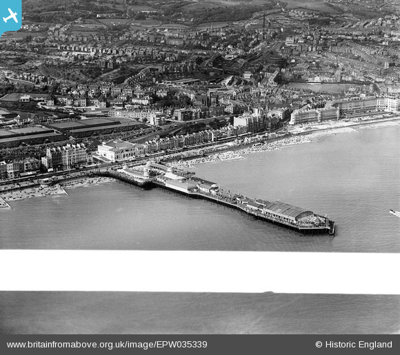
EPW035339 ENGLAND (1931). The pier and town, Hastings, 1931. This image was marked by Aerofilms Ltd for photo editing.
© Copyright OpenStreetMap contributors and licensed by the OpenStreetMap Foundation. 2026. Cartography is licensed as CC BY-SA.
Nearby Images (24)
Details
| Title | [EPW035339] The pier and town, Hastings, 1931. This image was marked by Aerofilms Ltd for photo editing. |
| Reference | EPW035339 |
| Date | 25-May-1931 |
| Link | |
| Place name | HASTINGS |
| Parish | |
| District | |
| Country | ENGLAND |
| Easting / Northing | 581227, 109091 |
| Longitude / Latitude | 0.57495890904828, 50.852345019514 |
| National Grid Reference | TQ812091 |
Pins
Be the first to add a comment to this image!


![[EPW035339] The pier and town, Hastings, 1931. This image was marked by Aerofilms Ltd for photo editing.](http://britainfromabove.org.uk/sites/all/libraries/aerofilms-images/public/100x100/EPW/035/EPW035339.jpg)
![[EPW026200] The Pier, White Rock Pavilion and bowling greens, Hastings, 1929](http://britainfromabove.org.uk/sites/all/libraries/aerofilms-images/public/100x100/EPW/026/EPW026200.jpg)
![[EAW022975] The pier, White Rock Pleasure Grounds and the town, Hastings, from the south-east, 1949](http://britainfromabove.org.uk/sites/all/libraries/aerofilms-images/public/100x100/EAW/022/EAW022975.jpg)
![[EPW039390] Hastings Pier, the town and the seafront, Hastings, from the east, 1932](http://britainfromabove.org.uk/sites/all/libraries/aerofilms-images/public/100x100/EPW/039/EPW039390.jpg)
![[EPW039388] The Hastings Pier Band Stand, Hastings, 1932](http://britainfromabove.org.uk/sites/all/libraries/aerofilms-images/public/100x100/EPW/039/EPW039388.jpg)
![[EPW035334] The pier and White Rock Pavilion, Hastings, 1931](http://britainfromabove.org.uk/sites/all/libraries/aerofilms-images/public/100x100/EPW/035/EPW035334.jpg)
![[EPW026209] The White Rock Pleasure Grounds and the pier, Hastings, 1929](http://britainfromabove.org.uk/sites/all/libraries/aerofilms-images/public/100x100/EPW/026/EPW026209.jpg)
![[EPW000060B] Hastings Pier, Hastings, 1920](http://britainfromabove.org.uk/sites/all/libraries/aerofilms-images/public/100x100/EPW/000/EPW000060B.jpg)
![[EPW044648] The White Rock Pavilion, the seafront and the Royal East Sussex Hospital, Hastings, 1934](http://britainfromabove.org.uk/sites/all/libraries/aerofilms-images/public/100x100/EPW/044/EPW044648.jpg)
![[EPW026191] The White Rock Pavilion and band stand at the entrance to the pier, Hastings, 1929](http://britainfromabove.org.uk/sites/all/libraries/aerofilms-images/public/100x100/EPW/026/EPW026191.jpg)
![[EPW042839] The Promenade, White Rock Pleasure Gardens and the town, Hastings, from the east, 1933](http://britainfromabove.org.uk/sites/all/libraries/aerofilms-images/public/100x100/EPW/042/EPW042839.jpg)
![[EAW002408] The town and seafront from the pier to Claremont, Hastings, from the south-east, 1946](http://britainfromabove.org.uk/sites/all/libraries/aerofilms-images/public/100x100/EAW/002/EAW002408.jpg)
![[EPW026188] The Pier, Hastings, 1929](http://britainfromabove.org.uk/sites/all/libraries/aerofilms-images/public/100x100/EPW/026/EPW026188.jpg)
![[EPW000754] The Pier and town centre, Hastings, 1920](http://britainfromabove.org.uk/sites/all/libraries/aerofilms-images/public/100x100/EPW/000/EPW000754.jpg)
![[EAW002407] The town and seafront from the White Rock Pavilion to Carlisle Parade, Hastings, from the south-east, 1946](http://britainfromabove.org.uk/sites/all/libraries/aerofilms-images/public/100x100/EAW/002/EAW002407.jpg)
![[EPW035342] The pier and town, Hastings, from the west, 1931](http://britainfromabove.org.uk/sites/all/libraries/aerofilms-images/public/100x100/EPW/035/EPW035342.jpg)
![[EPW035346] The pier, Hastings, 1931](http://britainfromabove.org.uk/sites/all/libraries/aerofilms-images/public/100x100/EPW/035/EPW035346.jpg)
![[EAW002409] White Rock Pleasure Grounds and the seafront west of the pier, Hastings, from the south-east, 1946](http://britainfromabove.org.uk/sites/all/libraries/aerofilms-images/public/100x100/EAW/002/EAW002409.jpg)
![[EPW042840] The pier, Hastings, 1933](http://britainfromabove.org.uk/sites/all/libraries/aerofilms-images/public/100x100/EPW/042/EPW042840.jpg)
![[EPW035345] The pier, Hastings, 1931](http://britainfromabove.org.uk/sites/all/libraries/aerofilms-images/public/100x100/EPW/035/EPW035345.jpg)
![[EAW030089] The Pier Head, Hastings, 1950](http://britainfromabove.org.uk/sites/all/libraries/aerofilms-images/public/100x100/EAW/030/EAW030089.jpg)
![[EAW006618] The seafront and town, Hastings, from the south-west, 1947](http://britainfromabove.org.uk/sites/all/libraries/aerofilms-images/public/100x100/EAW/006/EAW006618.jpg)
![[EPW000115] White Rock, Hastings, 1920](http://britainfromabove.org.uk/sites/all/libraries/aerofilms-images/public/100x100/EPW/000/EPW000115.jpg)
![[EAW006619] The seafront and town, Hastings, from the south-west, 1947](http://britainfromabove.org.uk/sites/all/libraries/aerofilms-images/public/100x100/EAW/006/EAW006619.jpg)