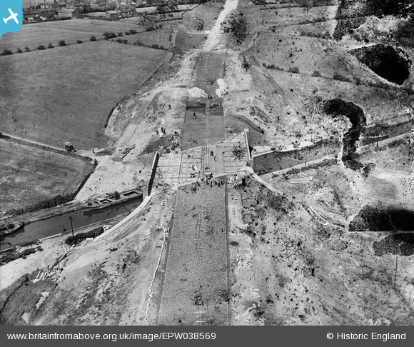
EPW038569 ENGLAND (1932). The East Lancashire Road (A580) and Morley's Bridge under construction crossing the Bridgewater Canal, Town Lane, 1932. This image has been produced from a damaged negative.
© Copyright OpenStreetMap contributors and licensed by the OpenStreetMap Foundation. 2026. Cartography is licensed as CC BY-SA.
Nearby Images (8)
Details
| Title | [EPW038569] The East Lancashire Road (A580) and Morley's Bridge under construction crossing the Bridgewater Canal, Town Lane, 1932. This image has been produced from a damaged negative. |
| Reference | EPW038569 |
| Date | June-1932 |
| Link | |
| Place name | TOWN LANE |
| Parish | |
| District | |
| Country | ENGLAND |
| Easting / Northing | 369061, 399474 |
| Longitude / Latitude | -2.4663685347824, 53.490813706744 |
| National Grid Reference | SJ691995 |
Pins
Be the first to add a comment to this image!


![[EPW038569] The East Lancashire Road (A580) and Morley's Bridge under construction crossing the Bridgewater Canal, Town Lane, 1932. This image has been produced from a damaged negative.](http://britainfromabove.org.uk/sites/all/libraries/aerofilms-images/public/100x100/EPW/038/EPW038569.jpg)
![[EPW037206] Morley Bridge under construction, Marsland Green, 1931](http://britainfromabove.org.uk/sites/all/libraries/aerofilms-images/public/100x100/EPW/037/EPW037206.jpg)
![[EPW037209] Morley Bridge under construction, Marsland Green, 1931](http://britainfromabove.org.uk/sites/all/libraries/aerofilms-images/public/100x100/EPW/037/EPW037209.jpg)
![[EPW037207] Morley Bridge under construction, Marsland Green, 1931](http://britainfromabove.org.uk/sites/all/libraries/aerofilms-images/public/100x100/EPW/037/EPW037207.jpg)
![[EPW037208] Morley Bridge under construction, Marsland Green, 1931](http://britainfromabove.org.uk/sites/all/libraries/aerofilms-images/public/100x100/EPW/037/EPW037208.jpg)
![[EPW038568] The East Lancashire Road (A580) and Morley's Bridge under construction crossing the Bridgewater Canal, Town Lane, from the west, 1932](http://britainfromabove.org.uk/sites/all/libraries/aerofilms-images/public/100x100/EPW/038/EPW038568.jpg)
![[EPW031132] The A580 under construction, Town Lane, from the west, 1929](http://britainfromabove.org.uk/sites/all/libraries/aerofilms-images/public/100x100/EPW/031/EPW031132.jpg)
![[EPW031131] The A580 under construction, Town Lane, from the south-west, 1929](http://britainfromabove.org.uk/sites/all/libraries/aerofilms-images/public/100x100/EPW/031/EPW031131.jpg)