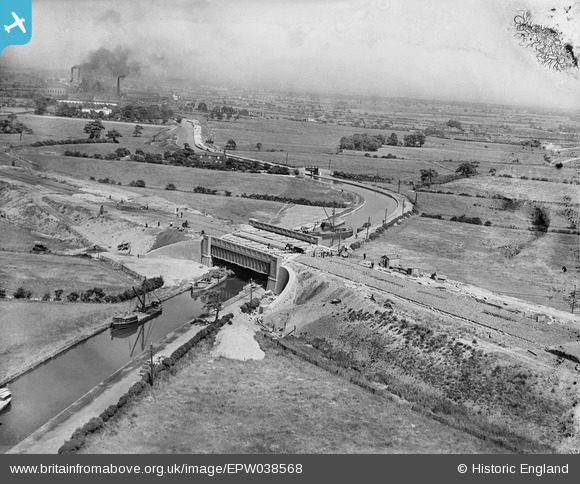
EPW038568 ENGLAND (1932). The East Lancashire Road (A580) and Morley's Bridge under construction crossing the Bridgewater Canal, Town Lane, from the west, 1932
© Copyright OpenStreetMap contributors and licensed by the OpenStreetMap Foundation. 2026. Cartography is licensed as CC BY-SA.
Nearby Images (7)
Details
| Title | [EPW038568] The East Lancashire Road (A580) and Morley's Bridge under construction crossing the Bridgewater Canal, Town Lane, from the west, 1932 |
| Reference | EPW038568 |
| Date | June-1932 |
| Link | |
| Place name | TOWN LANE |
| Parish | |
| District | |
| Country | ENGLAND |
| Easting / Northing | 369003, 399461 |
| Longitude / Latitude | -2.4672414993223, 53.490693433178 |
| National Grid Reference | SJ690995 |
Pins

John W |
Wednesday 4th of August 2021 09:53:39 PM | |

John W |
Wednesday 4th of August 2021 09:51:52 PM | |

SMJ |
Saturday 25th of May 2013 07:55:19 PM | |
If this is from the west, I don't see how that can be Chat Moss. |

JWN |
Thursday 14th of November 2013 12:01:38 AM |

SMJ |
Saturday 25th of May 2013 07:54:48 PM | |

SMJ |
Saturday 25th of May 2013 07:54:10 PM | |

SMJ |
Saturday 25th of May 2013 07:53:13 PM | |
Morleys Hall is to the West (Liverpool side) of the canal bridge and just out of shot. The cottages have been demolished and also the bridge has been replaced by a 'Pipe Bridge' with a footpath. |

Dave |
Tuesday 29th of October 2013 12:59:26 PM |
User Comment Contributions
I'm afraid that is not Morleys hall as its on the same side as Peel Hall the white bldng to the rear left, Morleys hall is to the right of this image over the A580. |

longbow64 |
Wednesday 4th of November 2015 12:37:36 AM |
correct the site is what was Holts boat yard(1830) and around the time of the photo ceased to function a year or so before |

alf ridyard |
Wednesday 4th of November 2015 12:37:36 AM |


![[EPW038568] The East Lancashire Road (A580) and Morley's Bridge under construction crossing the Bridgewater Canal, Town Lane, from the west, 1932](http://britainfromabove.org.uk/sites/all/libraries/aerofilms-images/public/100x100/EPW/038/EPW038568.jpg)
![[EPW037209] Morley Bridge under construction, Marsland Green, 1931](http://britainfromabove.org.uk/sites/all/libraries/aerofilms-images/public/100x100/EPW/037/EPW037209.jpg)
![[EPW038569] The East Lancashire Road (A580) and Morley's Bridge under construction crossing the Bridgewater Canal, Town Lane, 1932. This image has been produced from a damaged negative.](http://britainfromabove.org.uk/sites/all/libraries/aerofilms-images/public/100x100/EPW/038/EPW038569.jpg)
![[EPW037206] Morley Bridge under construction, Marsland Green, 1931](http://britainfromabove.org.uk/sites/all/libraries/aerofilms-images/public/100x100/EPW/037/EPW037206.jpg)
![[EPW037207] Morley Bridge under construction, Marsland Green, 1931](http://britainfromabove.org.uk/sites/all/libraries/aerofilms-images/public/100x100/EPW/037/EPW037207.jpg)
![[EPW037208] Morley Bridge under construction, Marsland Green, 1931](http://britainfromabove.org.uk/sites/all/libraries/aerofilms-images/public/100x100/EPW/037/EPW037208.jpg)
![[EPW031132] The A580 under construction, Town Lane, from the west, 1929](http://britainfromabove.org.uk/sites/all/libraries/aerofilms-images/public/100x100/EPW/031/EPW031132.jpg)