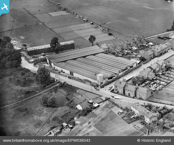
EPW038343 ENGLAND (1932). Stephens Glevum Incubator Works, Gloucester, 1932
    © Copyright OpenStreetMap contributors and licensed by the OpenStreetMap Foundation. 2025. Cartography is licensed as CC BY-SA.
  
Nearby Images (17)
Details
| Title | [EPW038343] Stephens Glevum Incubator Works, Gloucester, 1932 | 
| Reference | EPW038343 | 
| Date | July-1932 | 
| Link | |
| Place name | GLOUCESTER | 
| Parish | |
| District | |
| Country | ENGLAND | 
| Easting / Northing | 382270, 218044 | 
| Longitude / Latitude | -2.2574885465846, 51.860257110982 | 
| National Grid Reference | SO823180 | 
Pins
Be the first to add a comment to this image!
 
             
  ![[EPW038343] Stephens Glevum Incubator Works, Gloucester, 1932](http://britainfromabove.org.uk/sites/all/libraries/aerofilms-images/public/100x100/EPW/038/EPW038343.jpg) 
  
                                          ![[EPW038344] Stephens Glevum Incubator Works, Gloucester, 1932](http://britainfromabove.org.uk/sites/all/libraries/aerofilms-images/public/100x100/EPW/038/EPW038344.jpg) 
 ![[EPW038346] Stephens Glevum Incubator Works and grounds of Llanthony Secunda Priory, Gloucester, 1932](http://britainfromabove.org.uk/sites/all/libraries/aerofilms-images/public/100x100/EPW/038/EPW038346.jpg) 
 ![[EPW038348] Stephens Glevum Incubator Works, Gloucester, 1932](http://britainfromabove.org.uk/sites/all/libraries/aerofilms-images/public/100x100/EPW/038/EPW038348.jpg) 
 ![[EPW038347] Stephens Glevum Incubator Works and Llanthony Secunda Priory, Gloucester, 1932](http://britainfromabove.org.uk/sites/all/libraries/aerofilms-images/public/100x100/EPW/038/EPW038347.jpg) 
 ![[EPW038345] Stephens Glevum Incubator Works and Llanthony Secunda Priory, Gloucester, 1932](http://britainfromabove.org.uk/sites/all/libraries/aerofilms-images/public/100x100/EPW/038/EPW038345.jpg) 
 ![[EPW037837] Railway sidings next to Llanthony Priory and surroundings, Gloucester, 1932](http://britainfromabove.org.uk/sites/all/libraries/aerofilms-images/public/100x100/EPW/037/EPW037837.jpg) 
 ![[EAW012211] Gloucester Docks, the remains of Llanthony Secunda Priory and the surrounding industrial area, Gloucester, 1947](http://britainfromabove.org.uk/sites/all/libraries/aerofilms-images/public/100x100/EAW/012/EAW012211.jpg) 
 ![[EAW012198] Gloucester Docks, Gloucester, 1947](http://britainfromabove.org.uk/sites/all/libraries/aerofilms-images/public/100x100/EAW/012/EAW012198.jpg) 
 ![[EPW024157] Llanthony Lock and Weir, Gloucester, 1928](http://britainfromabove.org.uk/sites/all/libraries/aerofilms-images/public/100x100/EPW/024/EPW024157.jpg) 
 ![[EAW012196] Gloucester Docks, Gloucester, 1947](http://britainfromabove.org.uk/sites/all/libraries/aerofilms-images/public/100x100/EAW/012/EAW012196.jpg) 
 ![[EAW018728] The site of Llanthony Secunda Priory, Castle Meads and environs, Gloucester, 1948. This image has been produced from a print.](http://britainfromabove.org.uk/sites/all/libraries/aerofilms-images/public/100x100/EAW/018/EAW018728.jpg) 
 ![[EPW048240] The Gloucester and Sharpness Canal, the Docks and the city, Gloucester, from the south, 1935. This image has been produced from a copy-negative.](http://britainfromabove.org.uk/sites/all/libraries/aerofilms-images/public/100x100/EPW/048/EPW048240.jpg) 
 ![[EAW012208] Gloucester Docks and the surrounding industrial area, Gloucester, 1947](http://britainfromabove.org.uk/sites/all/libraries/aerofilms-images/public/100x100/EAW/012/EAW012208.jpg) 
 ![[EPW037836] Monk Meadow Dock, Llanthony Priory and the docks, Gloucester, 1932](http://britainfromabove.org.uk/sites/all/libraries/aerofilms-images/public/100x100/EPW/037/EPW037836.jpg) 
 ![[EAW012210] Gloucester Docks and the surrounding industrial area, Gloucester, 1947](http://britainfromabove.org.uk/sites/all/libraries/aerofilms-images/public/100x100/EAW/012/EAW012210.jpg) 
 ![[EAW021185] Castle Meads Power Station and the docks, Gloucester, 1949. This image has been produced from a print.](http://britainfromabove.org.uk/sites/all/libraries/aerofilms-images/public/100x100/EAW/021/EAW021185.jpg)