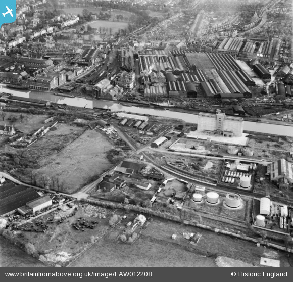
EAW012208 ENGLAND (1947). Gloucester Docks and the surrounding industrial area, Gloucester, 1947
© Copyright OpenStreetMap contributors and licensed by the OpenStreetMap Foundation. 2026. Cartography is licensed as CC BY-SA.
Nearby Images (26)
Details
| Title | [EAW012208] Gloucester Docks and the surrounding industrial area, Gloucester, 1947 |
| Reference | EAW012208 |
| Date | 13-November-1947 |
| Link | |
| Place name | GLOUCESTER |
| Parish | |
| District | |
| Country | ENGLAND |
| Easting / Northing | 382375, 217799 |
| Longitude / Latitude | -2.2559511722162, 51.85805743105 |
| National Grid Reference | SO824178 |


![[EAW012208] Gloucester Docks and the surrounding industrial area, Gloucester, 1947](http://britainfromabove.org.uk/sites/all/libraries/aerofilms-images/public/100x100/EAW/012/EAW012208.jpg)
![[EAW012199] Gloucester Docks, Gloucester, 1947](http://britainfromabove.org.uk/sites/all/libraries/aerofilms-images/public/100x100/EAW/012/EAW012199.jpg)
![[EAW012198] Gloucester Docks, Gloucester, 1947](http://britainfromabove.org.uk/sites/all/libraries/aerofilms-images/public/100x100/EAW/012/EAW012198.jpg)
![[EAW012206] Gloucester Docks and the surrounding industrial area, Gloucester, 1947](http://britainfromabove.org.uk/sites/all/libraries/aerofilms-images/public/100x100/EAW/012/EAW012206.jpg)
![[EAW012196] Gloucester Docks, Gloucester, 1947](http://britainfromabove.org.uk/sites/all/libraries/aerofilms-images/public/100x100/EAW/012/EAW012196.jpg)
![[EPW037836] Monk Meadow Dock, Llanthony Priory and the docks, Gloucester, 1932](http://britainfromabove.org.uk/sites/all/libraries/aerofilms-images/public/100x100/EPW/037/EPW037836.jpg)
![[EPW016966] The Gloucester Railway Carriage and Wagon Co Ltd, Gloucester, 1926](http://britainfromabove.org.uk/sites/all/libraries/aerofilms-images/public/100x100/EPW/016/EPW016966.jpg)
![[EPW048240] The Gloucester and Sharpness Canal, the Docks and the city, Gloucester, from the south, 1935. This image has been produced from a copy-negative.](http://britainfromabove.org.uk/sites/all/libraries/aerofilms-images/public/100x100/EPW/048/EPW048240.jpg)
![[EAW012201] Gloucester Docks, Gloucester, 1947](http://britainfromabove.org.uk/sites/all/libraries/aerofilms-images/public/100x100/EAW/012/EAW012201.jpg)
![[EAW012205] Monk Meadow Dock and the surrounding industrial area, Gloucester, 1947](http://britainfromabove.org.uk/sites/all/libraries/aerofilms-images/public/100x100/EAW/012/EAW012205.jpg)
![[EPW037770] Monk Meadow Dock and environs, Hempsted, 1932](http://britainfromabove.org.uk/sites/all/libraries/aerofilms-images/public/100x100/EPW/037/EPW037770.jpg)
![[EAW032298] The Gloucester Railway Carriage and Wagon Company Works and environs, Gloucester, 1950. This image was marked by Aerofilms Ltd for photo editing.](http://britainfromabove.org.uk/sites/all/libraries/aerofilms-images/public/100x100/EAW/032/EAW032298.jpg)
![[EPW024167] Monk Meadow Wharf, Gloucester, 1928](http://britainfromabove.org.uk/sites/all/libraries/aerofilms-images/public/100x100/EPW/024/EPW024167.jpg)
![[EAW032297] The Gloucester Railway Carriage and Wagon Company Works and environs, Gloucester, 1950. This image was marked by Aerofilms Ltd for photo editing.](http://britainfromabove.org.uk/sites/all/libraries/aerofilms-images/public/100x100/EAW/032/EAW032297.jpg)
![[EAW012203] Monk Meadow Dock and the surrounding industrial area, Gloucester, 1947](http://britainfromabove.org.uk/sites/all/libraries/aerofilms-images/public/100x100/EAW/012/EAW012203.jpg)
![[EAW032302] The Gloucester Railway Carriage and Wagon Company Works and environs, Gloucester, 1950. This image was marked by Aerofilms Ltd for photo editing.](http://britainfromabove.org.uk/sites/all/libraries/aerofilms-images/public/100x100/EAW/032/EAW032302.jpg)
![[EAW012211] Gloucester Docks, the remains of Llanthony Secunda Priory and the surrounding industrial area, Gloucester, 1947](http://britainfromabove.org.uk/sites/all/libraries/aerofilms-images/public/100x100/EAW/012/EAW012211.jpg)
![[EPW038348] Stephens Glevum Incubator Works, Gloucester, 1932](http://britainfromabove.org.uk/sites/all/libraries/aerofilms-images/public/100x100/EPW/038/EPW038348.jpg)
![[EPW038346] Stephens Glevum Incubator Works and grounds of Llanthony Secunda Priory, Gloucester, 1932](http://britainfromabove.org.uk/sites/all/libraries/aerofilms-images/public/100x100/EPW/038/EPW038346.jpg)
![[EPW038347] Stephens Glevum Incubator Works and Llanthony Secunda Priory, Gloucester, 1932](http://britainfromabove.org.uk/sites/all/libraries/aerofilms-images/public/100x100/EPW/038/EPW038347.jpg)
![[EAW032294] The Gloucester Railway Carriage and Wagon Company Works and environs, Gloucester, 1950](http://britainfromabove.org.uk/sites/all/libraries/aerofilms-images/public/100x100/EAW/032/EAW032294.jpg)
![[EAW032295] The Gloucester Railway Carriage and Wagon Company Works and environs, Gloucester, 1950. This image was marked by Aerofilms Ltd for photo editing.](http://britainfromabove.org.uk/sites/all/libraries/aerofilms-images/public/100x100/EAW/032/EAW032295.jpg)
![[EPW038345] Stephens Glevum Incubator Works and Llanthony Secunda Priory, Gloucester, 1932](http://britainfromabove.org.uk/sites/all/libraries/aerofilms-images/public/100x100/EPW/038/EPW038345.jpg)
![[EPW038343] Stephens Glevum Incubator Works, Gloucester, 1932](http://britainfromabove.org.uk/sites/all/libraries/aerofilms-images/public/100x100/EPW/038/EPW038343.jpg)
![[EPW038344] Stephens Glevum Incubator Works, Gloucester, 1932](http://britainfromabove.org.uk/sites/all/libraries/aerofilms-images/public/100x100/EPW/038/EPW038344.jpg)
![[EPW037769] Monk Meadow Dock, Llanthony Priory and environs, Hempsted, 1932](http://britainfromabove.org.uk/sites/all/libraries/aerofilms-images/public/100x100/EPW/037/EPW037769.jpg)

