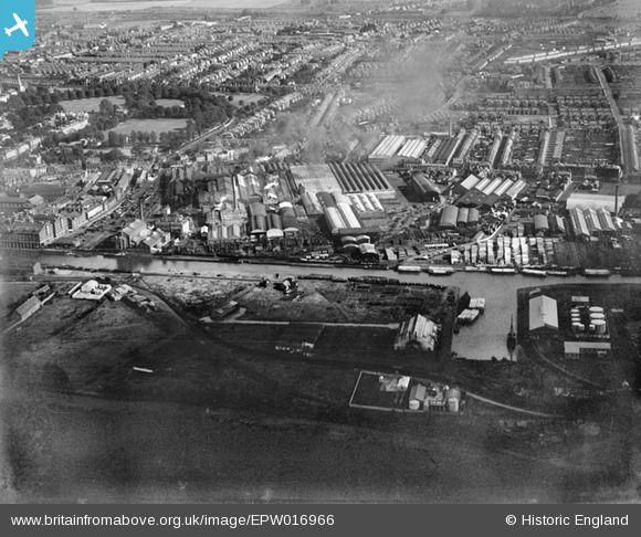
EPW016966 ENGLAND (1926). The Gloucester Railway Carriage and Wagon Co Ltd, Gloucester, 1926
© Copyright OpenStreetMap contributors and licensed by the OpenStreetMap Foundation. 2026. Cartography is licensed as CC BY-SA.
Nearby Images (25)
Details
| Title | [EPW016966] The Gloucester Railway Carriage and Wagon Co Ltd, Gloucester, 1926 |
| Reference | EPW016966 |
| Date | 1-October-1926 |
| Link | |
| Place name | GLOUCESTER |
| Parish | |
| District | |
| Country | ENGLAND |
| Easting / Northing | 382455, 217691 |
| Longitude / Latitude | -2.2547839353432, 51.857088830767 |
| National Grid Reference | SO825177 |


![[EPW016966] The Gloucester Railway Carriage and Wagon Co Ltd, Gloucester, 1926](http://britainfromabove.org.uk/sites/all/libraries/aerofilms-images/public/100x100/EPW/016/EPW016966.jpg)
![[EAW012206] Gloucester Docks and the surrounding industrial area, Gloucester, 1947](http://britainfromabove.org.uk/sites/all/libraries/aerofilms-images/public/100x100/EAW/012/EAW012206.jpg)
![[EAW032297] The Gloucester Railway Carriage and Wagon Company Works and environs, Gloucester, 1950. This image was marked by Aerofilms Ltd for photo editing.](http://britainfromabove.org.uk/sites/all/libraries/aerofilms-images/public/100x100/EAW/032/EAW032297.jpg)
![[EAW032302] The Gloucester Railway Carriage and Wagon Company Works and environs, Gloucester, 1950. This image was marked by Aerofilms Ltd for photo editing.](http://britainfromabove.org.uk/sites/all/libraries/aerofilms-images/public/100x100/EAW/032/EAW032302.jpg)
![[EPW037836] Monk Meadow Dock, Llanthony Priory and the docks, Gloucester, 1932](http://britainfromabove.org.uk/sites/all/libraries/aerofilms-images/public/100x100/EPW/037/EPW037836.jpg)
![[EAW012208] Gloucester Docks and the surrounding industrial area, Gloucester, 1947](http://britainfromabove.org.uk/sites/all/libraries/aerofilms-images/public/100x100/EAW/012/EAW012208.jpg)
![[EAW032298] The Gloucester Railway Carriage and Wagon Company Works and environs, Gloucester, 1950. This image was marked by Aerofilms Ltd for photo editing.](http://britainfromabove.org.uk/sites/all/libraries/aerofilms-images/public/100x100/EAW/032/EAW032298.jpg)
![[EAW012199] Gloucester Docks, Gloucester, 1947](http://britainfromabove.org.uk/sites/all/libraries/aerofilms-images/public/100x100/EAW/012/EAW012199.jpg)
![[EPW048245] The Gloucester and Sharpness Canal and the city, Gloucester, from the south, 1935. This image has been produced from a copy-negative.](http://britainfromabove.org.uk/sites/all/libraries/aerofilms-images/public/100x100/EPW/048/EPW048245.jpg)
![[EAW012201] Gloucester Docks, Gloucester, 1947](http://britainfromabove.org.uk/sites/all/libraries/aerofilms-images/public/100x100/EAW/012/EAW012201.jpg)
![[EAW012203] Monk Meadow Dock and the surrounding industrial area, Gloucester, 1947](http://britainfromabove.org.uk/sites/all/libraries/aerofilms-images/public/100x100/EAW/012/EAW012203.jpg)
![[EAW032295] The Gloucester Railway Carriage and Wagon Company Works and environs, Gloucester, 1950. This image was marked by Aerofilms Ltd for photo editing.](http://britainfromabove.org.uk/sites/all/libraries/aerofilms-images/public/100x100/EAW/032/EAW032295.jpg)
![[EAW032294] The Gloucester Railway Carriage and Wagon Company Works and environs, Gloucester, 1950](http://britainfromabove.org.uk/sites/all/libraries/aerofilms-images/public/100x100/EAW/032/EAW032294.jpg)
![[EAW032296] The Gloucester Railway Carriage and Wagon Company Works, Bristol Road and environs, Gloucester, 1950. This image was marked by Aerofilms Ltd for photo editing.](http://britainfromabove.org.uk/sites/all/libraries/aerofilms-images/public/100x100/EAW/032/EAW032296.jpg)
![[EAW012198] Gloucester Docks, Gloucester, 1947](http://britainfromabove.org.uk/sites/all/libraries/aerofilms-images/public/100x100/EAW/012/EAW012198.jpg)
![[EAW032299] The Gloucester Railway Carriage and Wagon Company Works and environs, Gloucester, 1950. This image was marked by Aerofilms Ltd for photo editing.](http://britainfromabove.org.uk/sites/all/libraries/aerofilms-images/public/100x100/EAW/032/EAW032299.jpg)
![[EAW032301] The Gloucester Railway Carriage and Wagon Company Works and environs, Gloucester, 1950](http://britainfromabove.org.uk/sites/all/libraries/aerofilms-images/public/100x100/EAW/032/EAW032301.jpg)
![[EAW032293] The Gloucester Railway Carriage and Wagon Company Works and environs, Gloucester, 1950. This image was marked by Aerofilms Ltd for photo editing.](http://britainfromabove.org.uk/sites/all/libraries/aerofilms-images/public/100x100/EAW/032/EAW032293.jpg)
![[EAW012196] Gloucester Docks, Gloucester, 1947](http://britainfromabove.org.uk/sites/all/libraries/aerofilms-images/public/100x100/EAW/012/EAW012196.jpg)
![[EAW012205] Monk Meadow Dock and the surrounding industrial area, Gloucester, 1947](http://britainfromabove.org.uk/sites/all/libraries/aerofilms-images/public/100x100/EAW/012/EAW012205.jpg)
![[EPW037770] Monk Meadow Dock and environs, Hempsted, 1932](http://britainfromabove.org.uk/sites/all/libraries/aerofilms-images/public/100x100/EPW/037/EPW037770.jpg)
![[EPW048240] The Gloucester and Sharpness Canal, the Docks and the city, Gloucester, from the south, 1935. This image has been produced from a copy-negative.](http://britainfromabove.org.uk/sites/all/libraries/aerofilms-images/public/100x100/EPW/048/EPW048240.jpg)
![[EPW024167] Monk Meadow Wharf, Gloucester, 1928](http://britainfromabove.org.uk/sites/all/libraries/aerofilms-images/public/100x100/EPW/024/EPW024167.jpg)
![[EAW032300] The Gloucester Railway Carriage and Wagon Company Works and environs, Gloucester, 1950. This image was marked by Aerofilms Ltd for photo editing.](http://britainfromabove.org.uk/sites/all/libraries/aerofilms-images/public/100x100/EAW/032/EAW032300.jpg)
![[EPW037771] Monk Meadow Dock, Llanthony Priory and environs, Hempsted, 1932](http://britainfromabove.org.uk/sites/all/libraries/aerofilms-images/public/100x100/EPW/037/EPW037771.jpg)
