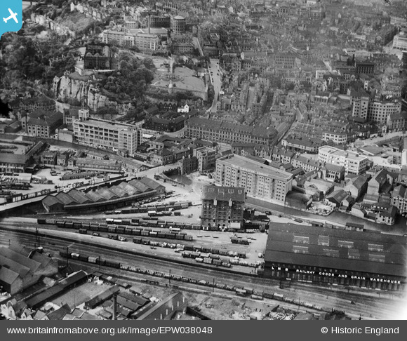
EPW038048 ENGLAND (1932). The Trent Navigation Company warehouse and environs, Nottingham, 1932
© Copyright OpenStreetMap contributors and licensed by the OpenStreetMap Foundation. 2026. Cartography is licensed as CC BY-SA.
Nearby Images (21)
Details
| Title | [EPW038048] The Trent Navigation Company warehouse and environs, Nottingham, 1932 |
| Reference | EPW038048 |
| Date | May-1932 |
| Link | |
| Place name | NOTTINGHAM |
| Parish | |
| District | |
| Country | ENGLAND |
| Easting / Northing | 457129, 339308 |
| Longitude / Latitude | -1.1496654626802, 52.947796423631 |
| National Grid Reference | SK571393 |


![[EPW038048] The Trent Navigation Company warehouse and environs, Nottingham, 1932](http://britainfromabove.org.uk/sites/all/libraries/aerofilms-images/public/100x100/EPW/038/EPW038048.jpg)
![[EPW038049] The Trent Navigation Company warehouse and environs, Nottingham, 1932](http://britainfromabove.org.uk/sites/all/libraries/aerofilms-images/public/100x100/EPW/038/EPW038049.jpg)
![[EPW038046] The Trent Navigation Company warehouse and environs, Nottingham, 1932](http://britainfromabove.org.uk/sites/all/libraries/aerofilms-images/public/100x100/EPW/038/EPW038046.jpg)
![[EPW038047] The Trent Navigation Company warehouse on Island Wharf, Nottingham, 1932](http://britainfromabove.org.uk/sites/all/libraries/aerofilms-images/public/100x100/EPW/038/EPW038047.jpg)
![[EPW019376] The Viyella Garments Factory on Castle Boulevard, Nottingham, 1927](http://britainfromabove.org.uk/sites/all/libraries/aerofilms-images/public/100x100/EPW/019/EPW019376.jpg)
![[EPW050652] The L.M.S. Railway Goods and Grain Warehouse, the site of Nottingham Castle and the city centre, Nottingham, 1936](http://britainfromabove.org.uk/sites/all/libraries/aerofilms-images/public/100x100/EPW/050/EPW050652.jpg)
![[EAW021700] The Goods Shed off Carrington Street and the city centre, Nottingham, from the south-west, 1949. This image has been produced from a print.](http://britainfromabove.org.uk/sites/all/libraries/aerofilms-images/public/100x100/EAW/021/EAW021700.jpg)
![[EAW006396] The castle and environs, Nottingham, 1947. This image has been produced from a print.](http://britainfromabove.org.uk/sites/all/libraries/aerofilms-images/public/100x100/EAW/006/EAW006396.jpg)
![[EAW009531] The city, Nottingham, from the south-west, 1947](http://britainfromabove.org.uk/sites/all/libraries/aerofilms-images/public/100x100/EAW/009/EAW009531.jpg)
![[EAW006395] The castle and environs, Nottingham, 1947. This image has been produced from a print.](http://britainfromabove.org.uk/sites/all/libraries/aerofilms-images/public/100x100/EAW/006/EAW006395.jpg)
![[EAW006400] The castle and environs, Nottingham, 1947. This image has been produced from a print.](http://britainfromabove.org.uk/sites/all/libraries/aerofilms-images/public/100x100/EAW/006/EAW006400.jpg)
![[EAW006399] The site of Nottingham Castle and the Castle Museum and Art Gallery, Nottingham, 1947](http://britainfromabove.org.uk/sites/all/libraries/aerofilms-images/public/100x100/EAW/006/EAW006399.jpg)
![[EPW038629] The Castle, Nottingham, 1932](http://britainfromabove.org.uk/sites/all/libraries/aerofilms-images/public/100x100/EPW/038/EPW038629.jpg)
![[EAW025942] Nottingham Castle and the city centre, Nottingham, from the south, 1949](http://britainfromabove.org.uk/sites/all/libraries/aerofilms-images/public/100x100/EAW/025/EAW025942.jpg)
![[EAW042518] Nottingham Castle, Nottingham, 1952](http://britainfromabove.org.uk/sites/all/libraries/aerofilms-images/public/100x100/EAW/042/EAW042518.jpg)
![[EAW044654] Nottingham Castle Museum and Art Gallery and environs, Nottingham, 1952](http://britainfromabove.org.uk/sites/all/libraries/aerofilms-images/public/100x100/EAW/044/EAW044654.jpg)
![[EAW050485] Nottingham Castle, Museum & Art Gallery and environs, Nottingham, 1953](http://britainfromabove.org.uk/sites/all/libraries/aerofilms-images/public/100x100/EAW/050/EAW050485.jpg)
![[EPW038632] The Castle, Nottingham, 1932](http://britainfromabove.org.uk/sites/all/libraries/aerofilms-images/public/100x100/EPW/038/EPW038632.jpg)
![[EAW006397] The site of Nottingham Castle and the Castle Museum and Art Gallery, Nottingham, 1947](http://britainfromabove.org.uk/sites/all/libraries/aerofilms-images/public/100x100/EAW/006/EAW006397.jpg)
![[EPW012557] Nottingham Castle, Castle Museum and Art Gallery and the city, Nottingham, 1925. This image has been produced from a print.](http://britainfromabove.org.uk/sites/all/libraries/aerofilms-images/public/100x100/EPW/012/EPW012557.jpg)
![[EAW006401] The site of Nottingham Castle and the city centre, Nottingham, 1947](http://britainfromabove.org.uk/sites/all/libraries/aerofilms-images/public/100x100/EAW/006/EAW006401.jpg)
