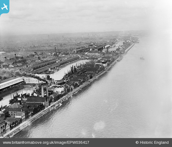
EPW036417 ENGLAND (1931). Billingsgate Fish Market, St Andrew's Dock and the River Humber, Kingston upon Hull, from the south-west, 1931. This image has been affected by flare.
© Copyright OpenStreetMap contributors and licensed by the OpenStreetMap Foundation. 2026. Cartography is licensed as CC BY-SA.
Details
| Title | [EPW036417] Billingsgate Fish Market, St Andrew's Dock and the River Humber, Kingston upon Hull, from the south-west, 1931. This image has been affected by flare. |
| Reference | EPW036417 |
| Date | August-1931 |
| Link | |
| Place name | KINGSTON UPON HULL |
| Parish | |
| District | |
| Country | ENGLAND |
| Easting / Northing | 507369, 426770 |
| Longitude / Latitude | -0.37246096652697, 53.72604252089 |
| National Grid Reference | TA074268 |
Pins

Daniel |
Sunday 29th of November 2015 02:24:37 PM |


![[EPW036417] Billingsgate Fish Market, St Andrew's Dock and the River Humber, Kingston upon Hull, from the south-west, 1931. This image has been affected by flare.](http://britainfromabove.org.uk/sites/all/libraries/aerofilms-images/public/100x100/EPW/036/EPW036417.jpg)
![[EPW036419] Billingsgate Fish Market, St Andrew's Dock and the River Humber, Kingston upon Hull, from the south-west, 1931](http://britainfromabove.org.uk/sites/all/libraries/aerofilms-images/public/100x100/EPW/036/EPW036419.jpg)
![[EPW055052] St Andrew's Dock, William Wright Dock and Albert Dock, Kingston upon Hull, from the south-west, 1937](http://britainfromabove.org.uk/sites/all/libraries/aerofilms-images/public/100x100/EPW/055/EPW055052.jpg)
![[EAW046149] St Andrew's Dock and environs, Kingston upon Hull, from the south-east, 1952](http://britainfromabove.org.uk/sites/all/libraries/aerofilms-images/public/100x100/EAW/046/EAW046149.jpg)