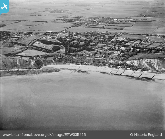
EPW035425 ENGLAND (1931). St Margaret's Bay and the village, St Margaret's-at-Cliffe, 1931
© Copyright OpenStreetMap contributors and licensed by the OpenStreetMap Foundation. 2026. Cartography is licensed as CC BY-SA.
Nearby Images (12)
Details
| Title | [EPW035425] St Margaret's Bay and the village, St Margaret's-at-Cliffe, 1931 |
| Reference | EPW035425 |
| Date | May-1931 |
| Link | |
| Place name | ST MARGARET'S-AT-CLIFFE |
| Parish | ST. MARGARET'S AT CLIFFE |
| District | |
| Country | ENGLAND |
| Easting / Northing | 636825, 144444 |
| Longitude / Latitude | 1.38668454264, 51.14964805254 |
| National Grid Reference | TR368444 |
Pins

David Busby |
Sunday 7th of July 2013 10:15:14 AM |
User Comment Contributions
How spooky to see the plot our house now stands on! |

David Busby |
Sunday 7th of July 2013 10:14:17 AM |


![[EPW035425] St Margaret's Bay and the village, St Margaret's-at-Cliffe, 1931](http://britainfromabove.org.uk/sites/all/libraries/aerofilms-images/public/100x100/EPW/035/EPW035425.jpg)
![[EPW009193] Hotel Road and St Margaret's Bay area, St Margaret's at Cliffe, 1923](http://britainfromabove.org.uk/sites/all/libraries/aerofilms-images/public/100x100/EPW/009/EPW009193.jpg)
![[EPW000671] St Margaret's Bay, St Margaret's at Cliffe, 1920](http://britainfromabove.org.uk/sites/all/libraries/aerofilms-images/public/100x100/EPW/000/EPW000671.jpg)
![[EAW024841] The sea front, St Margaret's at Cliffe, 1949](http://britainfromabove.org.uk/sites/all/libraries/aerofilms-images/public/100x100/EAW/024/EAW024841.jpg)
![[EPW000674] St Margaret's Bay, St Margaret's at Cliffe, from the south-east, 1920](http://britainfromabove.org.uk/sites/all/libraries/aerofilms-images/public/100x100/EPW/000/EPW000674.jpg)
![[EAW020466] The Granville Hotel and environs, St Margaret's at Cliffe, 1948. This image was marked by Aerofilms Ltd for photo editing.](http://britainfromabove.org.uk/sites/all/libraries/aerofilms-images/public/100x100/EAW/020/EAW020466.jpg)
![[EPW000672] St Margaret's Bay, St Margaret's at Cliffe, 1920](http://britainfromabove.org.uk/sites/all/libraries/aerofilms-images/public/100x100/EPW/000/EPW000672.jpg)
![[EPW035422] The village and St Margaret's Bay, St Margaret's-at-Cliffe, 1931](http://britainfromabove.org.uk/sites/all/libraries/aerofilms-images/public/100x100/EPW/035/EPW035422.jpg)
![[EPW035424] St Margaret's Bay and the village, St Margaret's-at-Cliffe, 1931](http://britainfromabove.org.uk/sites/all/libraries/aerofilms-images/public/100x100/EPW/035/EPW035424.jpg)
![[EPW035423] St Margaret's Bay, Ness Point and the village, St Margaret's-at-Cliffe, from the south-east, 1931](http://britainfromabove.org.uk/sites/all/libraries/aerofilms-images/public/100x100/EPW/035/EPW035423.jpg)
![[EPW000673] St Margaret's Bay, St Margaret's at Cliffe, from the south-west, 1920](http://britainfromabove.org.uk/sites/all/libraries/aerofilms-images/public/100x100/EPW/000/EPW000673.jpg)
![[EAW020465] St Margaret's Road and environs, St Margaret's at Cliffe, 1948](http://britainfromabove.org.uk/sites/all/libraries/aerofilms-images/public/100x100/EAW/020/EAW020465.jpg)