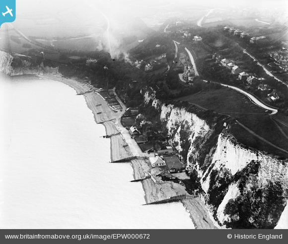
EPW000672 ENGLAND (1920). St Margaret's Bay, St Margaret's at Cliffe, 1920
© Copyright OpenStreetMap contributors and licensed by the OpenStreetMap Foundation. 2026. Cartography is licensed as CC BY-SA.
Nearby Images (9)
Details
| Title | [EPW000672] St Margaret's Bay, St Margaret's at Cliffe, 1920 |
| Reference | EPW000672 |
| Date | April-1920 |
| Link | |
| Place name | ST MARGARET'S AT CLIFFE |
| Parish | ST. MARGARET'S AT CLIFFE |
| District | |
| Country | ENGLAND |
| Easting / Northing | 636910, 144577 |
| Longitude / Latitude | 1.3879853227217, 51.15080686097 |
| National Grid Reference | TR369446 |
Pins

john cotton |
Tuesday 26th of March 2013 02:19:06 PM | |

john cotton |
Tuesday 26th of March 2013 02:18:35 PM | |

john cotton |
Tuesday 26th of March 2013 02:17:29 PM |


![[EPW000672] St Margaret's Bay, St Margaret's at Cliffe, 1920](http://britainfromabove.org.uk/sites/all/libraries/aerofilms-images/public/100x100/EPW/000/EPW000672.jpg)
![[EPW035422] The village and St Margaret's Bay, St Margaret's-at-Cliffe, 1931](http://britainfromabove.org.uk/sites/all/libraries/aerofilms-images/public/100x100/EPW/035/EPW035422.jpg)
![[EAW020466] The Granville Hotel and environs, St Margaret's at Cliffe, 1948. This image was marked by Aerofilms Ltd for photo editing.](http://britainfromabove.org.uk/sites/all/libraries/aerofilms-images/public/100x100/EAW/020/EAW020466.jpg)
![[EPW000671] St Margaret's Bay, St Margaret's at Cliffe, 1920](http://britainfromabove.org.uk/sites/all/libraries/aerofilms-images/public/100x100/EPW/000/EPW000671.jpg)
![[EPW009193] Hotel Road and St Margaret's Bay area, St Margaret's at Cliffe, 1923](http://britainfromabove.org.uk/sites/all/libraries/aerofilms-images/public/100x100/EPW/009/EPW009193.jpg)
![[EAW024841] The sea front, St Margaret's at Cliffe, 1949](http://britainfromabove.org.uk/sites/all/libraries/aerofilms-images/public/100x100/EAW/024/EAW024841.jpg)
![[EPW035425] St Margaret's Bay and the village, St Margaret's-at-Cliffe, 1931](http://britainfromabove.org.uk/sites/all/libraries/aerofilms-images/public/100x100/EPW/035/EPW035425.jpg)
![[EPW000670] Granville Road, St Margaret's at Cliffe, from the north-east, 1920](http://britainfromabove.org.uk/sites/all/libraries/aerofilms-images/public/100x100/EPW/000/EPW000670.jpg)
![[EPW000674] St Margaret's Bay, St Margaret's at Cliffe, from the south-east, 1920](http://britainfromabove.org.uk/sites/all/libraries/aerofilms-images/public/100x100/EPW/000/EPW000674.jpg)