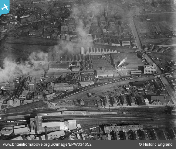
EPW034652 ENGLAND (1930). Stoneferry Canister Works, Kingston upon Hull, 1930
© Copyright OpenStreetMap contributors and licensed by the OpenStreetMap Foundation. 2026. Cartography is licensed as CC BY-SA.
Nearby Images (26)
Details
| Title | [EPW034652] Stoneferry Canister Works, Kingston upon Hull, 1930 |
| Reference | EPW034652 |
| Date | 16-October-1930 |
| Link | |
| Place name | KINGSTON UPON HULL |
| Parish | |
| District | |
| Country | ENGLAND |
| Easting / Northing | 510143, 430664 |
| Longitude / Latitude | -0.32904319918343, 53.760452834124 |
| National Grid Reference | TA101307 |
Pins

John Wass |
Tuesday 4th of July 2017 03:39:00 PM | |

John Wass |
Monday 25th of May 2015 04:26:55 PM | |

HullPaul |
Tuesday 12th of February 2013 12:48:31 PM |


![[EPW034652] Stoneferry Canister Works, Kingston upon Hull, 1930](http://britainfromabove.org.uk/sites/all/libraries/aerofilms-images/public/100x100/EPW/034/EPW034652.jpg)
![[EPW036518] Wilmington Junction, St Saviour's Church and the Stoneferry Canister Works, Kingston upon Hull, 1931](http://britainfromabove.org.uk/sites/all/libraries/aerofilms-images/public/100x100/EPW/036/EPW036518.jpg)
![[EPW036516] Wilmington Junction, St Saviour's Church and the Stoneferry Canister Works, Kingston upon Hull, 1931](http://britainfromabove.org.uk/sites/all/libraries/aerofilms-images/public/100x100/EPW/036/EPW036516.jpg)
![[EPW034649] Stoneferry Canister Works, Kingston upon Hull, 1930](http://britainfromabove.org.uk/sites/all/libraries/aerofilms-images/public/100x100/EPW/034/EPW034649.jpg)
![[EPW036517] The Stoneferry Canister Works, Kingston upon Hull, 1931](http://britainfromabove.org.uk/sites/all/libraries/aerofilms-images/public/100x100/EPW/036/EPW036517.jpg)
![[EPW047920] The British Extracting Company Works and environs, Stoneferry, 1935](http://britainfromabove.org.uk/sites/all/libraries/aerofilms-images/public/100x100/EPW/047/EPW047920.jpg)
![[EPW034655] Stoneferry Canister Works and the British Extracting Works, Kingston upon Hull, 1930](http://britainfromabove.org.uk/sites/all/libraries/aerofilms-images/public/100x100/EPW/034/EPW034655.jpg)
![[EPW034648] Stoneferry Canister Works, Kingston upon Hull, 1930](http://britainfromabove.org.uk/sites/all/libraries/aerofilms-images/public/100x100/EPW/034/EPW034648.jpg)
![[EPW034657] Stoneferry Canister Works, Kingston upon Hull, 1930](http://britainfromabove.org.uk/sites/all/libraries/aerofilms-images/public/100x100/EPW/034/EPW034657.jpg)
![[EPW034661] Ultramarine and Black Lead Works and Stoneferry Canister Works, Kingston upon Hull, 1930](http://britainfromabove.org.uk/sites/all/libraries/aerofilms-images/public/100x100/EPW/034/EPW034661.jpg)
![[EPW047925] The British Extracting Company Works and environs, Stoneferry, 1935](http://britainfromabove.org.uk/sites/all/libraries/aerofilms-images/public/100x100/EPW/047/EPW047925.jpg)
![[EPW047922] The British Extracting Company Works and environs, Stoneferry, 1935](http://britainfromabove.org.uk/sites/all/libraries/aerofilms-images/public/100x100/EPW/047/EPW047922.jpg)
![[EPW047923] The British Extracting Company Works and environs, Stoneferry, 1935](http://britainfromabove.org.uk/sites/all/libraries/aerofilms-images/public/100x100/EPW/047/EPW047923.jpg)
![[EPW047926] The British Extracting Company Works and environs, Stoneferry, 1935](http://britainfromabove.org.uk/sites/all/libraries/aerofilms-images/public/100x100/EPW/047/EPW047926.jpg)
![[EPW047927] The British Extracting Company Works and environs, Stoneferry, 1935](http://britainfromabove.org.uk/sites/all/libraries/aerofilms-images/public/100x100/EPW/047/EPW047927.jpg)
![[EPW047921] The British Extracting Company Works and environs, Stoneferry, 1935](http://britainfromabove.org.uk/sites/all/libraries/aerofilms-images/public/100x100/EPW/047/EPW047921.jpg)
![[EPW047933] The British Extracting Company Works and environs, Stoneferry, 1935](http://britainfromabove.org.uk/sites/all/libraries/aerofilms-images/public/100x100/EPW/047/EPW047933.jpg)
![[EPW047928] The British Extracting Company Works and environs, Stoneferry, 1935](http://britainfromabove.org.uk/sites/all/libraries/aerofilms-images/public/100x100/EPW/047/EPW047928.jpg)
![[EPW047932] The British Extracting Company Works and environs, Stoneferry, 1935](http://britainfromabove.org.uk/sites/all/libraries/aerofilms-images/public/100x100/EPW/047/EPW047932.jpg)
![[EPW047919] The British Extracting Company Works and environs, Stoneferry, 1935](http://britainfromabove.org.uk/sites/all/libraries/aerofilms-images/public/100x100/EPW/047/EPW047919.jpg)
![[EPW047934] The British Extracting Company Works and environs, Stoneferry, 1935](http://britainfromabove.org.uk/sites/all/libraries/aerofilms-images/public/100x100/EPW/047/EPW047934.jpg)
![[EPW047929] The British Extracting Company Works and environs, Stoneferry, 1935](http://britainfromabove.org.uk/sites/all/libraries/aerofilms-images/public/100x100/EPW/047/EPW047929.jpg)
![[EPW047924] The British Extracting Company Works and environs, Stoneferry, 1935](http://britainfromabove.org.uk/sites/all/libraries/aerofilms-images/public/100x100/EPW/047/EPW047924.jpg)
![[EPW034650] Ultramarine and Black Lead Works and other factories on Morley Street, Kingston upon Hull, 1930](http://britainfromabove.org.uk/sites/all/libraries/aerofilms-images/public/100x100/EPW/034/EPW034650.jpg)
![[EPW047930] The British Extracting Company Works and environs, Stoneferry, 1935](http://britainfromabove.org.uk/sites/all/libraries/aerofilms-images/public/100x100/EPW/047/EPW047930.jpg)
![[EPW036522] Hull Swing Bridge and the city, Kingston upon Hull, from the north, 1931](http://britainfromabove.org.uk/sites/all/libraries/aerofilms-images/public/100x100/EPW/036/EPW036522.jpg)